
Floyd County, Indiana facts for kids
Quick facts for kids
Floyd County
|
|
|---|---|

Floyd County, Indiana
|
|

Location within the U.S. state of Indiana
|
|
 Indiana's location within the U.S. |
|
| Country | |
| State | |
| Founded | 1819 |
| Named for | Brigadier General John Floyd |
| Seat | New Albany |
| Largest city | New Albany |
| Area | |
| • Total | 148.96 sq mi (385.8 km2) |
| • Land | 147.94 sq mi (383.2 km2) |
| • Water | 1.02 sq mi (2.6 km2) 0.68%% |
| Population
(2020)
|
|
| • Total | 80,484 |
| • Density | 504/sq mi (194.57/km2) |
| Time zone | UTC−5 (Eastern) |
| • Summer (DST) | UTC−4 (EDT) |
| Congressional district | 9th |
$3
|
|
Floyd County is a county in the state of Indiana. Its main city and government center is New Albany. In 2020, about 80,484 people lived here. Floyd County is the second smallest county in Indiana by land area. It was created in 1819 from parts of Clark and Harrison counties.
Floyd County is part of the larger Louisville, Kentucky, and Indiana metropolitan area.
Contents
History of Floyd County
The land that is now Floyd County was once a hunting ground for the Shawnee Indians. During the American Revolutionary War, George Rogers Clark took control of this area for the United States. He was given a lot of land in Indiana, including most of what is now Floyd County. Clark then sold parts of this land to settlers who began to arrive after the war.


By 1818, New Albany had grown large enough to become a county seat. Leaders from New Albany asked the state government to create a new county. The county was officially established on February 1, 1819.
The county's name is a bit of a mystery. Some believe it was named after John Floyd. He was an early pioneer in Jefferson County, Kentucky, and was killed by Native Americans in 1783. Others think it was named after Davis Floyd, who was a local political leader and the county's first judge.
New Albany was planned out in 1814 and became the county seat on March 4, 1819. For much of the early 1800s, New Albany was the largest city in Indiana. However, Indianapolis grew bigger during the Civil War.

Between 1800 and 1860, Floyd County's population grew very quickly. In the 1850s, a study showed that more than half of Indiana's wealthiest people lived in Floyd County. This made it the richest county in the state at that time.
The Duncan Tunnel was built in Floyd County in 1881. It is the longest tunnel in Indiana. Engineers decided to build a tunnel through the hills called Floyds Knobs because there was no good way to build a railroad over them. The tunnel is about 4,311 feet (1,314 meters) long. It took five years to build and cost $1 million.

During the 1800s, many immigrants came to Floyd County. People from Ireland, Germany, and France settled here, as did African Americans. French settlers mostly lived in Floyds Knobs, Indiana. Irish immigrants arrived starting in 1817. German immigrants mainly settled in New Albany. By 1850, about one in six people in the county were born in other countries.
Mount Saint Francis is a large property in Floyds Knobs. It is owned by the Conventual Franciscan Friars. The property has 400 acres of woods and a lake, which are open to the public. There are many hiking trails through the woods and fields.
Geography
Floyd County covers about 148.96 square miles (385.8 square kilometers). Most of this area is land (99.32%), with a small amount of water (0.68%). It is the second smallest county in Indiana.


Cities and Towns
- New Albany (the county seat)
- Georgetown
- Greenville
Other Communities
- Galena (a census-designated place)
Local Divisions
Floyd County is divided into five smaller areas called townships:
- Franklin
- Georgetown
- Greenville
- Lafayette
- New Albany
Natural Features
Floyd County is known for its hilly areas, especially the "Knobs Unit." These hills support many different types of trees. Some trees like dry areas on hilltops, while others prefer wet areas in valleys. Common trees include Sycamore, Flowering Dogwood, and Sugar Maple. The lowest point in the county is along the Ohio River near New Albany, at about 380 feet (116 meters) above sea level.
Transportation
- Transit Authority of River City (public transportation)
Main Roads
- Interstate 64
- Interstate 265
- U.S. Route 150
- Indiana State Road 11
- Indiana State Road 62
- Indiana State Road 64
- Indiana State Road 111
- Indiana State Road 335
Neighboring Counties
- Clark County (to the northeast)
- Jefferson County, Kentucky (to the south, across the Ohio River)
- Harrison County (to the west)
- Washington County (to the northwest)
Climate and Weather
| Weather chart for New Albany, Indiana | |||||||||||||||||||||||||||||||||||||||||||||||
|---|---|---|---|---|---|---|---|---|---|---|---|---|---|---|---|---|---|---|---|---|---|---|---|---|---|---|---|---|---|---|---|---|---|---|---|---|---|---|---|---|---|---|---|---|---|---|---|
| J | F | M | A | M | J | J | A | S | O | N | D | ||||||||||||||||||||||||||||||||||||
|
3.3
41
25
|
3.3
47
29
|
4.4
57
37
|
3.9
67
46
|
4.9
75
56
|
3.8
83
65
|
4.3
87
70
|
3.4
86
68
|
3.1
79
61
|
2.8
68
49
|
3.8
56
39
|
3.7
45
30
|
||||||||||||||||||||||||||||||||||||
| temperatures in °F precipitation totals in inches source: The Weather Channel |
|||||||||||||||||||||||||||||||||||||||||||||||
|
Metric conversion
|
|||||||||||||||||||||||||||||||||||||||||||||||
In New Albany, winter temperatures average from 25°F (-4°C) in January. Summer temperatures average up to 87°F (31°C) in July. The coldest temperature ever recorded was -22°F (-30°C) in January 1994. The hottest was 107°F (42°C) in July 1936. The county gets about 2.79 to 4.88 inches (7 to 12 cm) of rain each month.
Population and People
| Historical population | |||
|---|---|---|---|
| Census | Pop. | %± | |
| 1820 | 2,776 | — | |
| 1830 | 6,361 | 129.1% | |
| 1840 | 9,454 | 48.6% | |
| 1850 | 14,875 | 57.3% | |
| 1860 | 20,183 | 35.7% | |
| 1870 | 23,300 | 15.4% | |
| 1880 | 24,590 | 5.5% | |
| 1890 | 29,458 | 19.8% | |
| 1900 | 30,118 | 2.2% | |
| 1910 | 30,293 | 0.6% | |
| 1920 | 30,661 | 1.2% | |
| 1930 | 34,655 | 13.0% | |
| 1940 | 35,061 | 1.2% | |
| 1950 | 43,955 | 25.4% | |
| 1960 | 51,397 | 16.9% | |
| 1970 | 55,622 | 8.2% | |
| 1980 | 61,169 | 10.0% | |
| 1990 | 64,404 | 5.3% | |
| 2000 | 70,823 | 10.0% | |
| 2010 | 74,578 | 5.3% | |
| 2020 | 80,484 | 7.9% | |
| 2023 (est.) | 80,809 | 8.4% | |
| U.S. Decennial Census 1790–1960 1900–1990 1990–2000 2010 2020 |
|||
In 2010, there were 74,578 people living in Floyd County. Most residents (90.4%) were white. About 5.2% were black or African American. People of Hispanic or Latino origin made up 2.6% of the population. Many families in the county had children under 18 living with them. The average age of residents was 39.1 years.
Education
The New Albany-Floyd County Consolidated School Corporation serves the county. New Albany High School was the first public high school in Indiana. It opened in 1853. The school system has two high schools: New Albany High School and Floyd Central High School. There are also nine elementary schools and three middle schools. About 12,000 students attend schools in the district.
All residents of Floyd County can get a library card at the New Albany-Floyd County Public Library.
There is one university in Floyd County. The Indiana University Southeast campus is located in New Albany, Indiana. It covers 180 acres and is part of the Indiana University system. Around 7,000 students attend the school.
Images for kids
-

Baptist Floyd Health Hospital
-
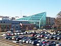
New Albany YMCA building
-
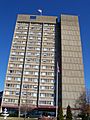
Riverview Towers, which was the tallest building in the county before it was torn down in 2022


See also
 In Spanish: Condado de Floyd (Indiana) para niños
