
Washington County, Indiana facts for kids
Quick facts for kids
Washington County
|
||
|---|---|---|

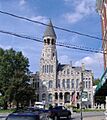
Washington County courthouse in Salem
|
||
|
||

Location within the U.S. state of Indiana
|
||
 Indiana's location within the U.S. |
||
| Country | ||
| State | ||
| Founded | 1814 | |
| Named for | George Washington | |
| Seat | Salem | |
| Largest city | Salem | |
| Area | ||
| • Total | 516.60 sq mi (1,338.0 km2) | |
| • Land | 513.72 sq mi (1,330.5 km2) | |
| • Water | 2.87 sq mi (7.4 km2) 0.56%% | |
| Population
(2020)
|
||
| • Total | 28,182 | |
| • Estimate
(2023)
|
28,205 |
|
| • Density | 54.5528/sq mi (21.0630/km2) | |
| Time zone | UTC−5 (Eastern) | |
| • Summer (DST) | UTC−4 (EDT) | |
| Congressional district | 9th | |
| Indiana county number 88 | ||

Washington County is a place in Indiana, a state in the United States. It's like a big neighborhood or district. In 2020, about 28,182 people lived here. The main town, called the county seat, is Salem. Washington County is also part of the larger Louisville metropolitan area.
Contents
Discovering Washington County's Past
Who Were the First Settlers?
Around 1802, a man named Frederick Royce lived near a place called the Lick. This was two miles east of Salem. He was likely the first white person to live in this area. Frederick was a hunter, trader, and made salt.
In 1803, Thomas Hopper became the first person to settle near Hardinsburg.
How Washington County Was Formed
Washington County was officially created in 1814. It was named after George Washington, who was the first President of the United States.
Exploring Washington County's Geography
Washington County covers about 516.60 square miles. Most of this area, about 513.72 square miles, is land. The rest, about 2.87 square miles, is water.
Neighboring Counties
Washington County shares its borders with several other counties:
- Jackson County (to the north)
- Scott County (to the northeast)
- Clark County (to the southeast)
- Floyd County (to the south-southeast)
- Harrison County (to the south)
- Crawford County (to the southwest)
- Orange County (to the west)
- Lawrence County (to the northwest)
Cities and Towns in Washington County
Here are the main cities and towns you can find in Washington County:
Special Designated Places
- Fredericksburg is a census-designated place. This means it's a community that is counted in the census but isn't officially a city or town.
Smaller Communities (Unincorporated Towns)
Many smaller communities are not officially incorporated as cities or towns. Some of these include:
- Bartle
- Beck's Mill
- Blue River
- Brimstone Corners
- Bunker Hill
- Canton
- Claysville
- Daisy Hill
- Fairview
- Farabee
- Fayetteville
- Georgetown
- Gooseport
- Haleysbury
- Harristown
- Highland
- Hitchcock
- Kossuth
- Martinsburg
- McKinley
- Millport
- Mount Carmel
- New Liberty
- New Philadelphia
- New Salem
- Old Pekin
- Organ Springs
- Plattsburg
- Prowsville
- Pumpkin Center
- Rosebud
- Rush Creek Valley
- Shorts Corner
- Smedley
- South Boston
Local Government Areas (Townships)
Washington County is divided into several townships for local government. These include:
- Brown
- Franklin
- Gibson
- Howard
- Jackson
- Jefferson
- Madison
- Monroe
- Pierce
- Polk
- Posey
- Vernon
- Washington
Main Roads in Washington County
These are the major highways that run through Washington County:
 Indiana State Road 56
 Indiana State Road 60
 Indiana State Road 135
 Indiana State Road 160
Climate and Weather in Washington County
| Weather chart for Salem, Indiana | |||||||||||||||||||||||||||||||||||||||||||||||
|---|---|---|---|---|---|---|---|---|---|---|---|---|---|---|---|---|---|---|---|---|---|---|---|---|---|---|---|---|---|---|---|---|---|---|---|---|---|---|---|---|---|---|---|---|---|---|---|
| J | F | M | A | M | J | J | A | S | O | N | D | ||||||||||||||||||||||||||||||||||||
|
3.3
39
21
|
3.2
46
25
|
4.3
56
33
|
4.6
67
42
|
4.9
76
51
|
3.9
84
60
|
4.4
87
64
|
4
86
62
|
3.1
79
55
|
2.9
68
44
|
3.9
55
36
|
3.7
44
26
|
||||||||||||||||||||||||||||||||||||
| temperatures in °F precipitation totals in inches source: The Weather Channel |
|||||||||||||||||||||||||||||||||||||||||||||||
|
Metric conversion
|
|||||||||||||||||||||||||||||||||||||||||||||||
In Salem, the average temperature in January is about 21°F. In July, it's around 87°F. The coldest temperature ever recorded was -32°F in February 1951. The hottest was 105°F in July 1954.
The amount of rain and snow changes throughout the year. May usually gets the most, about 4.86 inches. October gets the least, about 2.87 inches.
In March 2012, a series of strong storms, including tornadoes, affected Washington County. Sadly, some people lost their lives during this event.
Understanding Washington County's Population
| Historical population | |||
|---|---|---|---|
| Census | Pop. | %± | |
| 1820 | 9,039 | — | |
| 1830 | 13,064 | 44.5% | |
| 1840 | 15,269 | 16.9% | |
| 1850 | 17,040 | 11.6% | |
| 1860 | 17,909 | 5.1% | |
| 1870 | 18,495 | 3.3% | |
| 1880 | 18,955 | 2.5% | |
| 1890 | 18,619 | −1.8% | |
| 1900 | 19,409 | 4.2% | |
| 1910 | 17,445 | −10.1% | |
| 1920 | 16,645 | −4.6% | |
| 1930 | 16,285 | −2.2% | |
| 1940 | 17,008 | 4.4% | |
| 1950 | 16,520 | −2.9% | |
| 1960 | 17,819 | 7.9% | |
| 1970 | 19,278 | 8.2% | |
| 1980 | 21,932 | 13.8% | |
| 1990 | 23,717 | 8.1% | |
| 2000 | 27,223 | 14.8% | |
| 2010 | 28,262 | 3.8% | |
| 2020 | 28,182 | −0.3% | |
| 2023 (est.) | 28,205 | −0.2% | |
| US Decennial Census 1790-1960 1900-1990 1990-2000 2010 |
|||
What the 2010 Census Showed
In 2010, there were 28,262 people living in Washington County. These people lived in 10,850 households. A household is a group of people living together.
Most people in the county were white (98.1%). A small number were Asian, American Indian, or African American. About 1.1% of the population was of Hispanic or Latino background.
Many households (34.7%) had children under 18 living with them. About 54.8% of households were married couples. The average age of people in the county was 39.2 years old.
Education in Washington County
Washington County has several school districts that help students learn and grow.
School Districts Serving the County
- Salem Community Schools
- East Washington School Corporation
- South Central Area Special Ed
- West Washington School Corporation
East Washington School Corporation
This school district includes:
- East Washington Elementary School
- East Washington Middle School
- Eastern High School
Salem Community Schools
This district includes:
- Salem High School
- Salem Middle School
- Bradie Shrum Elementary School
West Washington School Corporation
This district includes:
- West Washington Elementary School
- West Washington Junior/Senior High School
Images for kids
-
Washington County courthouse in Salem
See also
 In Spanish: Condado de Washington (Indiana) para niños
