Orange County, Indiana facts for kids
Quick facts for kids
Orange County
|
|
|---|---|

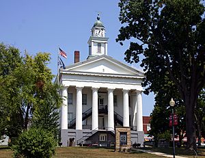
The Orange County courthouse in Paoli
|
|

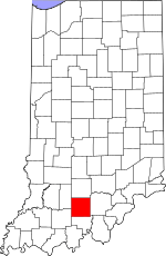
Location within the U.S. state of Indiana
|
|
 Indiana's location within the U.S. |
|
| Country | |
| State | |
| Founded | February 1, 1816 |
| Named for | King William of Orange (William III of England) |
| Seat | Paoli |
| Largest town | Paoli |
| Area | |
| • Total | 408.19 sq mi (1,057.2 km2) |
| • Land | 398.39 sq mi (1,031.8 km2) |
| • Water | 9.80 sq mi (25.4 km2) 2.40%% |
| Population
(2020)
|
|
| • Total | 19,867 |
| • Estimate
(2023)
|
19,638 |
| • Density | 48.6710/sq mi (18.7920/km2) |
| Time zone | UTC−5 (Eastern) |
| • Summer (DST) | UTC−4 (EDT) |
| Congressional district | 9th |
| Indiana county number 59 | |
Orange County is a place in Southern Indiana, United States. In 2020, about 19,867 people lived here. The main town, or county seat, is Paoli. The county has four towns where people live, with a total population of about 8,600. There are also many smaller communities. Orange County is divided into 10 areas called townships, which help provide local services. Several main roads and state roads pass through the county.
Contents
History of Orange County
Orange County was created from parts of other counties like Knox, Gibson, and Washington. This happened on December 26, 1815, and became official on February 1, 1816. The main town, Paoli, was named after a 12-year-old boy named Pasquale Paoli Ash.
Early Settlers and the Name
Many of the first settlers were Quakers. They came from North Carolina to escape slavery. In 1811, a group led by Jonathan Lindley arrived. They built the first religious building, the Lick Creek Meeting House, in 1813. Orange County got its name from this group. The name "Orange" comes from the Dutch Protestant House of Orange. This royal family took over the English throne in 1689 with King William III.
Little Africa Settlement
When the Quakers came to Indiana, they brought several formerly enslaved people who were now free. These free people were given about 200 acres (0.81 km2) of land in a thick forest. News of this land spread, and it became part of the "Underground Railroad" for people escaping slavery. For many years, the free people in this area farmed, traded, and worked for others. They built a church and a cemetery.
Today, only the cemetery remains. Many of the headstones are missing or damaged. Some years ago, Boy Scouts helped restore the cemetery. They replaced the lost stones with wooden crosses to mark the graves. This settlement was called "Little Africa" because of the Black community living there. However, its early users called it "Paddy's Garden."
The Courthouse Story
The very first courthouse was a simple log building. It cost only $25 to build! A stronger stone building was finished in 1819 for $3,950. In 1847, people decided to build an even bigger courthouse. This one was completed in 1850 and cost $14,000.
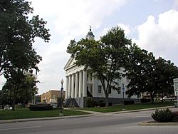
This building is the second oldest courthouse in Indiana that has been used non-stop since it was built. It looks like a Greek Revival building. It has two stories and a special front porch with columns. Inside, there are fancy iron stairs and a clock tower. In 1970, the clock tower was damaged by a fire.
Geography of Orange County
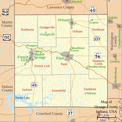
A large part of the southern county, south of Paoli and French Lick, is part of the Hoosier National Forest. Patoka Lake is also located within this forest. Most of the lake is in Orange County, but parts of it reach into nearby Dubois and Crawford counties.
Orange County covers a total area of about 408.19 square miles (1,057.2 km2). About 398.39 square miles (1,031.8 km2) of this is land, and 9.80 square miles (25.4 km2) is water.
Neighboring Counties
- Lawrence County – to the north
- Washington County – to the east
- Crawford County – to the south
- Dubois County – to the southwest
- Martin County – to the northwest
Towns in Orange County
- French Lick
- Orleans
- Paoli (the county seat)
- West Baden Springs
Small Communities
- Abydel
- Bacon
- Bonds
- Bromer
- Chambersburg
- Ethel
- Fargo
- Greenbrier
- Hindostan
- Leipsic
- Lost River
- Mahan Crossing
- Millersburg
- Newton Stewart
- Orangeville
- Pearsontown
- Pine Valley
- Prospect
- Pumpkin Center
- Rego
- Roland
- Scarlet
- Stampers Creek
- Syria
- Trotter Crossing
- Turleys
- Valeene
- Woodlawn Grove
- Youngs Creek
Moffatt Hollar
Townships in Orange County
- French Lick
- Greenfield
- Jackson
- Northeast
- Northwest
- Orangeville
- Orleans
- Paoli
- Southeast
- Stampers Creek
Transportation
Highways
- U.S. Route 150 – This road goes east to west through the middle of the county. It passes through French Lick, Turleys, and Paoli.
 Indiana State Road 37 – This road runs north to south through the center of the county. It goes through Orleans, Paoli, and Bacon.
 Indiana State Road 56 – This road enters the county from the west. It goes northeast to meet US-150 north of West Baden Springs.
 Indiana State Road 60 – This road crosses the very northeastern part of the county.
 Indiana State Road 145 – This road enters the county from the south. It runs north to meet Indiana-56 at French Lick.
 Indiana State Road 337 – This road goes southeast to northwest across the northeastern part of the county. It enters near Bromer and goes northwest to meet Indiana-37 at Orleans.
Airports
- Paoli Municipal Airport – This is a public airport with one paved runway.
- French Lick Municipal Airport (FRH) – This airport is owned by the city. It is located southwest of French Lick and serves the French Lick and West Baden areas.
Railways
The French Lick Scenic Railway offers fun train rides in Indiana. These 20-mile (32 km) tours go through parts of the Hoosier National Forest. You'll also pass through the 2,200-foot (670 m) Burton Tunnel, which is Indiana's second longest tunnel. You can also see cool limestone rock formations.
The railway has daily trips and special events throughout the year. Some popular family attractions include:
- Wild-West Hold-ups
- Tasting Trains
- Easter Bunny Express
- Dinner Trains
Climate and Weather
| Weather chart for Paoli, Indiana | |||||||||||||||||||||||||||||||||||||||||||||||
|---|---|---|---|---|---|---|---|---|---|---|---|---|---|---|---|---|---|---|---|---|---|---|---|---|---|---|---|---|---|---|---|---|---|---|---|---|---|---|---|---|---|---|---|---|---|---|---|
| J | F | M | A | M | J | J | A | S | O | N | D | ||||||||||||||||||||||||||||||||||||
|
3.3
38
18
|
3.1
44
22
|
4.4
55
31
|
4.8
65
40
|
5.1
75
50
|
4.2
83
60
|
4.5
87
64
|
4.2
85
62
|
3.3
79
53
|
2.9
68
40
|
4.2
55
32
|
3.6
43
23
|
||||||||||||||||||||||||||||||||||||
| temperatures in °F precipitation totals in inches source: The Weather Channel |
|||||||||||||||||||||||||||||||||||||||||||||||
|
Metric conversion
|
|||||||||||||||||||||||||||||||||||||||||||||||
In Paoli, the average temperatures change throughout the year. In January, it's usually around 18°F (-8°C). In July, it can get up to 87°F (31°C). The coldest temperature ever recorded was -29°F (-34°C) in January 1994. The hottest was 111°F (44°C) in July 1901.
The amount of rain and snow also changes. On average, October is the driest month with about 2.90 inches (7.4 cm) of precipitation. May is usually the wettest, with about 5.14 inches (13.1 cm).
Population Information
| Historical population | |||
|---|---|---|---|
| Census | Pop. | %± | |
| 1820 | 5,368 | — | |
| 1830 | 7,901 | 47.2% | |
| 1840 | 9,602 | 21.5% | |
| 1850 | 10,809 | 12.6% | |
| 1860 | 12,076 | 11.7% | |
| 1870 | 13,497 | 11.8% | |
| 1880 | 14,363 | 6.4% | |
| 1890 | 14,678 | 2.2% | |
| 1900 | 16,854 | 14.8% | |
| 1910 | 17,192 | 2.0% | |
| 1920 | 16,974 | −1.3% | |
| 1930 | 17,459 | 2.9% | |
| 1940 | 17,311 | −0.8% | |
| 1950 | 16,879 | −2.5% | |
| 1960 | 16,877 | 0.0% | |
| 1970 | 16,968 | 0.5% | |
| 1980 | 18,677 | 10.1% | |
| 1990 | 18,409 | −1.4% | |
| 2000 | 19,306 | 4.9% | |
| 2010 | 19,840 | 2.8% | |
| 2020 | 19,867 | 0.1% | |
| 2023 (est.) | 19,638 | −1.0% | |
| US Decennial Census 1790-1960 1900-1990 1990-2000 2010-2013 |
|||
In 2010, there were 19,840 people living in Orange County. Most people (97.0%) were white. About 0.9% were Black or African American. Other groups included Asian, American Indian, and people of two or more races. About 1.0% of the population was of Hispanic or Latino origin.
Many families live in Orange County. In 2010, about 32.3% of homes had children under 18 living there. The average household had about 2.49 people. The average age of people in the county was 40.8 years old.
Education
Orange County has four main school districts that serve its students:
- Lost River Career Cooperative
- Orleans Community Schools
- Paoli Community School Corporation
- Springs Valley Community School Corporation
Orleans Community Schools
The Superintendent for Orleans Community Schools is Jimmy Ellis. This district includes:
- Orleans Elementary School (Principal: Joni Lawyer)
- Orleans Jr./Sr. High School (Principal: Daniel Wolford)
Paoli Community Schools
The Superintendent for Paoli Community Schools is Greg Walker. This district includes:
- Throop Elementary School (Principal: Amanda Crews)
- Paoli Jr./Sr. High School (Principal: Dr. Sherry Wise)
Springs Valley Community School Corporation
The Superintendent for Springs Valley School Corporation is Trevor Apple. This district includes:
- Springs Valley Elementary School (Principal: Matthew Williams)
- Springs Valley Jr./Sr. High School (Principal: Kyle Neukam)
See also
 In Spanish: Condado de Orange (Indiana) para niños
 | Dorothy Vaughan |
 | Charles Henry Turner |
 | Hildrus Poindexter |
 | Henry Cecil McBay |


