Martin County, Indiana facts for kids
Quick facts for kids
Martin County
|
|
|---|---|

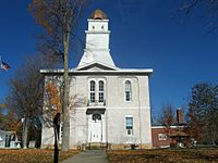
Martin County Courthouse
|
|

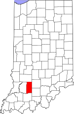
Location within the U.S. state of Indiana
|
|
 Indiana's location within the U.S. |
|
| Country | |
| State | |
| Founded | January 20, 1820 |
| Named for | Major John T. Martin |
| Seat | Shoals |
| Largest city | Loogootee |
| Area | |
| • Total | 340.41 sq mi (881.7 km2) |
| • Land | 335.74 sq mi (869.6 km2) |
| • Water | 4.67 sq mi (12.1 km2) 1.37% |
| Population
(2020)
|
|
| • Total | 9,812 |
| • Estimate
(2023)
|
9,897 |
| • Density | 28.8241/sq mi (11.1290/km2) |
| Time zone | UTC−5 (Eastern) |
| • Summer (DST) | UTC−4 (EDT) |
| Congressional district | 8th |
| Indiana county number 51 | |
Martin County is a place in Indiana, a state in the United States. In 2020, about 9,812 people lived here. The main town, or county seat, is Shoals, located in the middle of the county. The only official city in Martin County is Loogootee, which is on the western side.
Contents
History
Indiana became a state in late 1816. Soon after, the state government created Dubois and Daviess counties. Many settlers moved into southwest Indiana. It was hard for them to reach the main towns of those counties. So, on January 20, 1820, Martin County was formed from parts of Dubois and Daviess counties. It was named after Major John T. Martin from Newport, Kentucky.
Geography
Martin County has many hills covered with trees. There are also many small rivers and streams. The land is used for farming, buildings, or is managed by the U.S. Government. About one-third of the county is part of the Naval Surface Warfare Center Crane Division. This is a special area for the Navy. About one-quarter of the county is part of the Hoosier National Forest, a large protected forest.
The highest point in the county is about 870 feet (265 meters) above sea level. This spot is in Mitcheltree Township, inside the Navy area.
The East Fork of the White River flows through the lower part of the county. Indian Creek flows through the middle and joins the White River. Boggs Creek flows through the upper part and also joins the White River near the western edge.
In 2010, the county covered a total area of 340.41 square miles (881.6 square kilometers). Most of this, about 335.74 square miles (869.6 square kilometers), is land. The rest, 4.67 square miles (12.1 square kilometers), is water.
Neighboring Counties
- Greene County - to the north
- Lawrence County - to the east
- Orange County - to the southeast
- Dubois County - to the south
- Daviess County - to the west
Protected Natural Areas
- Hoosier National Forest (part) - This forest is in the northeast and southeast parts of Martin County. The U.S. Forest Service takes care of it.
- Martin State Forest - This forest is in the eastern part of Martin County. The Indiana Department of Natural Resources manages it.
Lakes
- Greenwood Lake
- Seed Tick Lake
- West Boggs Lake (part)
Roads and Highways
Cities and Towns
Smaller Communities
- Bramble
- Burns City
- Cale
- Dover Hill
- Hindostan Falls
- Indian Springs
- Ironton
- Lacy
- Mount Olive
- Mount Pleasant
- Natchez
- Padanaram
- Pleasant Valley
- Rusk
- Scenic Hill
- Shoals Overlook
- South Martin
- Trinity Springs
- Whitfield
- Willow Valley
- Windom
- Yenne
Townships
- Center
- Halbert
- Lost River
- Mitcheltree
- Perry
- Rutherford
Climate and Weather
| Weather chart for Shoals, Indiana | |||||||||||||||||||||||||||||||||||||||||||||||
|---|---|---|---|---|---|---|---|---|---|---|---|---|---|---|---|---|---|---|---|---|---|---|---|---|---|---|---|---|---|---|---|---|---|---|---|---|---|---|---|---|---|---|---|---|---|---|---|
| J | F | M | A | M | J | J | A | S | O | N | D | ||||||||||||||||||||||||||||||||||||
|
3.2
37
19
|
2.9
43
22
|
4.3
54
31
|
4.5
65
40
|
5.6
75
50
|
4.2
83
59
|
4.7
86
64
|
3.8
85
62
|
3.4
79
54
|
3.1
68
42
|
4.5
54
34
|
3.5
42
24
|
||||||||||||||||||||||||||||||||||||
| temperatures in °F precipitation totals in inches source: The Weather Channel |
|||||||||||||||||||||||||||||||||||||||||||||||
|
Metric conversion
|
|||||||||||||||||||||||||||||||||||||||||||||||
In Shoals, the average temperature in January is about 19°F (-7°C). In July, it's about 86°F (30°C). The coldest temperature ever recorded was -23°F (-31°C) in January 1994. The hottest was 104°F (40°C) in July 1954.
The amount of rain and snow changes throughout the year. February usually has the least, about 2.92 inches (7.4 cm). May usually has the most, about 5.60 inches (14.2 cm).
Education
| School | Type | Students | Mascot | Colors | IHSAA Class | Athletic Conference |
|---|---|---|---|---|---|---|
| Loogootee High School | Public | 325 | Lions | A | Blue Chip Conference | |
| Shoals High School | Public | 223 | JugRox | A | Blue Chip Conference |
Martin County has two main high schools. Both are public schools, meaning they are supported by the government. They are part of the Blue Chip Conference for sports.
People and Population
| Historical population | |||
|---|---|---|---|
| Census | Pop. | %± | |
| 1820 | 1,032 | — | |
| 1830 | 2,010 | 94.8% | |
| 1840 | 3,875 | 92.8% | |
| 1850 | 5,941 | 53.3% | |
| 1860 | 8,975 | 51.1% | |
| 1870 | 11,103 | 23.7% | |
| 1880 | 13,475 | 21.4% | |
| 1890 | 13,973 | 3.7% | |
| 1900 | 14,711 | 5.3% | |
| 1910 | 12,950 | −12.0% | |
| 1920 | 11,865 | −8.4% | |
| 1930 | 10,103 | −14.9% | |
| 1940 | 10,300 | 1.9% | |
| 1950 | 10,678 | 3.7% | |
| 1960 | 10,608 | −0.7% | |
| 1970 | 10,969 | 3.4% | |
| 1980 | 11,001 | 0.3% | |
| 1990 | 10,369 | −5.7% | |
| 2000 | 10,369 | 0.0% | |
| 2010 | 10,334 | −0.3% | |
| 2020 | 10,327 | −0.1% | |
| 2023 (est.) | 9,897 | −4.2% | |
| US Decennial Census 1790-1960 1900-1990 1990-2000 2010-2013 |
|||
What the 2010 Census Showed
In 2010, there were 10,334 people living in Martin County. They lived in 4,216 homes, and 2,832 of these were families. On average, there were about 31 people per square mile.
Most people in the county were white (98.4%). A small number were Asian, American Indian, or Black. About 0.7% of the people were of Hispanic or Latino background. Many people had family roots from Germany (27.8%), Ireland (19.2%), or England (14.9%).
About 30.5% of homes had children under 18 living there. More than half (52.8%) were married couples. The average age of people in the county was 41.8 years old.
The average income for a household was about $47,697 per year. For families, it was about $55,017. Some families and people had lower incomes, including some under 18 and some over 65.
See also
 In Spanish: Condado de Martin (Indiana) para niños
 | Victor J. Glover |
 | Yvonne Cagle |
 | Jeanette Epps |
 | Bernard A. Harris Jr. |

