
Hindostan Falls, Indiana facts for kids
Quick facts for kids
Hindostan Falls, Indiana
|
|
|---|---|
 |
|

Martin County's location in Indiana
|
|

Hindostan Falls, Indiana
Location in Martin County, Indiana
|
|
| Country | United States |
| State | Indiana |
| County | Martin |
| Township | Center |
| Elevation | 459 ft (140 m) |
| Population
(2000)
|
|
| • Total | 1 |
| Time zone | UTC-5 (Eastern (EST)) |
| • Summer (DST) | UTC-4 (EDT) |
| ZIP code |
47581
|
| Area code(s) | 812, 930 |
| FIPS code | 18-34024 |
| GNIS feature ID | 451046 |
Hindostan Falls is a place in Martin County, Indiana, that used to be a busy town. Today, it's an unincorporated community, which means it's a small area without its own local government. It's located near the beautiful falls of the East Fork of the White River.

Contents
The Start of Hindostan Falls
Hindostan Falls began as a town in 1816. It was built right next to the falls of the East Fork of the White River. This new settlement was on an important road. It was part of the original stagecoach route between New Albany and Vincennes. At the time, this was one of the few roads in the new state of Indiana.
By 1820, Hindostan Falls was the biggest community in what was then Daviess County. It was seen as the most promising town along the White River. An English soldier named Captain Caleb Fellows gave the town its name. He had worked in India before coming to the United States. He invested in land in Indiana and named the town "Hindostan."
A Growing Frontier Town
Around 1820, about 1,200 people lived in Hindostan Falls. This made it one of the largest towns in early Indiana. Many people even lived on houseboats on the White River! People were moving to new lands in Indiana and Illinois. Because Hindostan was on a main travel route, it was always open to new people. Sadly, this also meant it was open to diseases.
-

Pioneer cemetery, Hindostan Falls, Indiana

Why the Town Disappeared
In 1820, a serious illness, like yellow fever or cholera, spread through Hindostan. Towns built along rivers often faced problems with water- and insect-borne diseases. This was because they were often on flood plains, which are perfect places for insects to breed. The sickness was so bad that many people either got sick or left the area. By 1824, less than half of the town's population remained.
Money Troubles and Moving On
Around the same time, there was an economic depression, which means tough financial times. This also caused people to leave. Some families had bought land but couldn't pay for it anymore. They had to leave the area. Hindostan might have lost as many people to money problems as it did to sickness. Those who stayed couldn't pay their taxes. Their property was taken by the county.
There's a local story about a tax collector. He supposedly had thousands of dollars in gold and silver coins. He buried the money for safekeeping when he got sick. But he died, and the money's location was lost forever!
As the town slowly emptied, the post office, which opened in 1819, closed on December 29, 1830. Eventually, the land where the busy town once stood became farmland.
In 1828, the county seat (the main town for the county government) moved to Mt. Pleasant. Later, in 1853, most people left Mt. Pleasant for a new town called Loogootee, which was four miles from Hindostan. The county seat moved again to Trinity Springs, then to Shoals in 1871. Today, Shoals has about 690 people, which is half the size of Hindostan before it disappeared.
What's Left Today
Today, the area of Hindostan Falls is an Indiana state fishing and recreation spot. You can find a historic marker on State Highway 550. It's about half a mile north of where the town used to be. No buildings are left, but you can still see a few old pioneer cemeteries nearby. There's also a restored church.
You can also find many square holes in a large flat rock along the river. These holes were drilled to hold up a mill that used to be in Hindostan. The mill belonged to Frederick Shulz, and the town of Shoals was named after him.
Geography of Hindostan Falls
Hindostan Falls is located at 38°37′28″N 86°51′03″W / 38.62444°N 86.85083°W.
Gallery
-
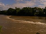
Hindostan Falls during high water on the East Fork White River
-
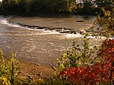
Hindostan Falls at low (three feet) water
-

One of the holes that supported a mill below Hindostan Falls


