
White River (Indiana) facts for kids
Quick facts for kids White River - IndianaWapahani |
|
|---|---|

A White River dam
|
|

The forks of the White River are highlighted in blue. The green area is the basin watershed.
|
|
| Country | United States |
| State | Indiana |
| Physical characteristics | |
| Main source | Washington Township 40°04′46″N 84°55′58″W / 40.0794906°N 84.9327413°W |
| River mouth | Wabash River Gibson County, Indiana, opposite Mount Carmel, Illinois 38°24′51″N 87°44′33″W / 38.4142134°N 87.7425280°W |
| Length | 362 mi (583 km) |
| Basin features | |
| Progression | Wabash-Ohio- Mississippi-Gulf of Mexico |
| Basin size | 5,746 sq mi (14,880 km2) |
The White River is a major river in Indiana, United States. It has two main branches, or "forks," that flow through the central and southern parts of the state. This river is the most important tributary to the Wabash River.
The longer branch, called the West Fork, is considered the main part of the river. The White River stretches about 362 miles (583 km) long. Indiana's capital city, Indianapolis, is built right along its banks. The two forks of the river join together just north of Petersburg. From there, the river flows into the Wabash River near Mount Carmel, Illinois.
Contents
The West Fork: Main Branch of the White River

The West Fork is the longest branch of the White River, measuring about 312 miles (502 km) long. Official maps from the U.S. Board on Geographic Names simply call it the "White River."
This fork begins south of Winchester in Randolph County. It flows through several cities, including Muncie, Anderson, Noblesville, and Indianapolis.
Along its path, the West Fork passes by three Indiana state parks:
- Mounds State Park, near Anderson.
- White River State Park, located in downtown Indianapolis.
- McCormick's Creek State Park, close to Spencer.
In Indianapolis, a path called the Wapahani Trail follows the river's eastern side. The Miami tribe, who are Native Americans, called the river Wapahani. This name means "white sands" or Waapi-nipi Siipiiwi, which means "white lake River."
The East Fork: Another Important Branch

The East Fork is also known as Aankwaahsakwa Siipiiw in the native Miami-Illinois language. This branch starts in Columbus. It forms where two other rivers, the Driftwood and Flatrock rivers, meet.
Even though it's called the "East Fork," the very beginning of the main West Fork is actually located further east! The East Fork flows for about 192 miles (309 km) generally southwest. It passes through the city of Seymour before flowing through some rough, hilly areas. Finally, it joins the West Fork.
The East Fork White River releases about 6,235 cubic feet (176.6 m3) of water per second just below where Lick Creek flows into it.
The Lower White River: Where the Forks Meet
After the East Fork joins the West Fork, the White River flows for another 50 miles (80 km). This lower section of the river runs between Gibson, Knox, and Pike counties.
It then empties into the Wabash River right at the border between Indiana and Illinois. This meeting point is near Mount Carmel, Illinois. The entire area that drains into the White River, called its watershed, covers more than 11,305 square miles (29,280 km2).
Fun Activities on the White River
Even though the river faces challenges from pollution, many people enjoy recreational activities on the White River. These activities include fishing, kayaking, and canoeing.
The White River Yacht Club is a group that uses pontoon boats on the river. A part of the river in northern Indianapolis even has riverside cottages and pontoon boats. However, the river is not deep enough in many places for larger sailing or power boats that have a deep keel (the part that extends below the boat).
Protecting the White River: Pollution Concerns
In 1997, the White River was named one of the most threatened rivers in the United States.
Farmers in the White River area use a lot of pesticides, like herbicides (which kill weeds) and insecticides (which kill insects). Most of these are used on corn and soybean crops. Between 1991 and 1995, the most common herbicides found near the mouth of the river were alachlor, atrazine, cyanazine, and metolachlor.
The highest amounts of herbicides in the river usually appear in late spring. This happens after the chemicals are applied and then washed into the river by rain. Over time, the levels of alachlor have gone down, while levels of acetochlor have gone up. This change is because farmers have started using different herbicides.
Only a small amount, about 1% or less, of the herbicides used on farms actually ends up in the river. Insecticides are also found, but in much smaller amounts than herbicides.
The 1999 Fish Kill and Recovery
In 1999, a very sad event happened on the West Fork. A huge number of fish died along a 50 miles (80 km) stretch of the river. About 4.6 million fish, weighing 187 tons, were lost.
Investigators found that a company called Guide Corp, which made car parts in Anderson, was responsible. They had accidentally released 10,000 US gallons (38,000 L) of a chemical called HMP 2000 into the river. Guide Corp later agreed to pay $14.2 million in fines, penalties, legal costs, and money to help restore the river.
Luckily, some animals that had dug into the mud were safe from the chemical. By March 2000, some fish naturally started to return to the affected area. The Indiana Department of Natural Resources also helped by adding new fish to the river in October.
In 2002, the city of Anderson announced it would spend millions of dollars to improve its sewage treatment system. Ten years after the fish kill, officials said the White River was actually in better condition than before the chemical spill. You can still see bleached stones along the riverbanks, which are a reminder of what happened.
Images for kids
-
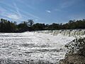
A White River dam
-
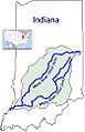
The forks of the White River are highlighted in blue. The green area is the basin watershed.
See also
 In Spanish: Río Blanco (Indiana) para niños
