
Gibson County, Indiana facts for kids
Quick facts for kids
Gibson County
|
|
|---|---|

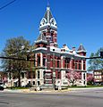
SE face of the Gibson County Courthouse in Princeton (built 1884) and the Civil War monument (1912)
|
|

Location within the U.S. state of Indiana
|
|
 Indiana's location within the U.S. |
|
| Country | |
| State | |
| Founded | April 1, 1813 |
| Named for | John Gibson |
| Seat | Princeton |
| Largest city | Princeton |
| Area | |
| • Total | 499.16 sq mi (1,292.8 km2) |
| • Land | 487.49 sq mi (1,262.6 km2) |
| • Water | 11.68 sq mi (30.3 km2) 2.34% |
| Population
(2020)
|
|
| • Total | 33,011 |
| • Density | 66.1331/sq mi (25.5341/km2) |
| Time zone | UTC−6 (Central) |
| • Summer (DST) | UTC−5 (CDT) |
| ZIP Codes |
47639, 47640, 47647, 47648, 47649, 47654, 47660, 47665, 47666, 47670, 47683
|
| Congressional district | 8th |
|
|
Gibson County is a county located in the southwestern part of Indiana, a state in the United States. In 2020, about 33,011 people lived here. The main town and county seat is Princeton.
Contents
History of Gibson County
How Gibson County Was Formed
In 1787, the United States created the Northwest Territory. This large area included what is now Indiana. Later, in 1800, the Indiana Territory was formed. William Henry Harrison became its first governor. The capital was set up in Vincennes.
Over time, parts of the Indiana Territory became other states or territories. By 1816, Indiana was ready to become a state. Before this, the U.S. government acquired land from Native American tribes. This happened through treaties and agreements. The land that would become Gibson County was acquired in 1804.
People started settling in this area around 1789. By 1813, there were enough people to form a local government. Gibson County was officially created on April 1, 1813. It was named after John Gibson. He was an officer in earlier wars and served as acting Governor of the Indiana Territory.
Early Settlers and Life
The first European settler in the future Gibson County was John Severns. He arrived around 1789-1790. He settled near the Patoka River. Another early settler was William Hargrove, who came from Kentucky in 1803. He led a group of local soldiers at the Battle of Tippecanoe in 1811.

The Rev. Joseph Milburn and his son Robert also arrived in 1803. They settled near Princeton. Rev. Milburn started the first church in the area.
In 1805, Jacob Warrick arrived. He was involved in conflicts with the last Native American village in the area. Captain Warrick was also killed at the Battle of Tippecanoe in 1811.
When Gibson County was first organized, Patoka was meant to be the county seat. However, Patoka was in a low area near the Patoka River. This led to a serious illness outbreak called malaria. Because of this, officials decided to build a new town on higher ground. This town became Princeton. Some records suggest Owensville might have been a temporary county seat before Princeton was fully established.
The Underground Railroad in Gibson County
Even though Indiana was a "free state," helping runaway slaves was against the law. People who did so could be arrested and jailed. Despite these risks, many people in Gibson County were part of the Underground Railroad. This was a secret network that helped enslaved people escape to freedom.
People like David Stormont and his wife had a safe house near Princeton. John Carithers also helped runaway slaves at his home. Sarah Merrick from Princeton was even jailed for helping a mother and her children escape from nearby Kentucky. Reverend Thomas B. McCormick, a minister, was so well-known for his anti-slavery work that he had to flee to Canada.
James Washington Cockrum ran a station at his home in Oakland City. He hid runaways in a root cellar. His son, William, later wrote a book about their experiences. Their family home, Cockrum Hall, is now on the grounds of Oakland City University. It is recognized as an important stop on the Underground Railroad.
Geography of Gibson County
Gibson County is mostly a rural area. About 90% of it is within the Ohio River Valley AVA. This means it's a good place for growing grapes. Even though some central areas are growing, many townships still have small populations.
Land and Rivers
The western part of the county has many farms. These areas can flood easily near the Wabash and White Rivers. There are also rolling hills around Owensville. Large forests and marshlands are found near the Gibson Generating Station.
The northern part of the county is near the White River. It has more hills and forests. The eastern part also has many hills. It has areas where coal has been mined. The southern part has valleys and marshlands. These are drained by the Pigeon Creek. The highest point in the county is a hill north of Princeton. It is about 640 feet/200 meters above sea level.


A part of the Patoka River National Wildlife Refuge and Management Area is located in Gibson County. This refuge protects wildlife and their habitats.
The county covers about 499.16 square miles (1,292.8 km2). Most of this, about 487.49 square miles (1,262.6 km2), is land. The rest, about 11.68 square miles (30.3 km2), is water.
Neighboring Counties
- White County, Illinois − west
- Wabash County, Illinois − northwest
- Knox County − north
- Pike County − east
- Warrick County − southeast
- Vanderburgh County − south
- Posey County − southwest
Cities and Towns
Gibson County has two cities and several towns:
|
|
- Buckskin (47647)
- Fort Branch (47648)
- Francisco (47649)
- Haubstadt (47639)
- Hazleton (47640)
- Mackey (47654)
- Owensville (47665)
- Patoka (47666)
- Somerville (47683)

Unincorporated Communities
These are smaller communities that are not officially cities or towns:
- Baldwin Heights *
- Buena Vista (Giro)
- Crawleyville
- Calamity
- Dongola
- East Mount Carmel
- Gray Junction
- Hickory Ridge (Hickory)
- Johnson
- Kings Station (Kings)
- Lyles Station
- Mount Olympus
- Northbrook Hills *
- Oak Hill
- Oatsville
- Port Gibson
- Saint James
- Skelton (now under Gibson Lake)
- Snake Run
- Warrenton
- Wheeling (Kirkville)
* Baldwin Heights and Northbrook Hills are within the city limits of Princeton.
Townships
Gibson County is divided into ten areas called townships:
- Barton
- Center
- Columbia
- Johnson
- Montgomery
- Patoka
- Union
- Wabash
- Washington
- White River
Climate and Weather
| Weather chart for Princeton, Indiana | |||||||||||||||||||||||||||||||||||||||||||||||
|---|---|---|---|---|---|---|---|---|---|---|---|---|---|---|---|---|---|---|---|---|---|---|---|---|---|---|---|---|---|---|---|---|---|---|---|---|---|---|---|---|---|---|---|---|---|---|---|
| J | F | M | A | M | J | J | A | S | O | N | D | ||||||||||||||||||||||||||||||||||||
|
2.9
38
21
|
3
44
26
|
4.2
55
35
|
4.5
66
45
|
5.1
76
55
|
3.9
84
64
|
3.9
88
67
|
4.1
86
65
|
3.2
79
58
|
3.2
68
46
|
4.4
54
36
|
3.6
42
26
|
||||||||||||||||||||||||||||||||||||
| temperatures in °F precipitation totals in inches source: The Weather Channel |
|||||||||||||||||||||||||||||||||||||||||||||||
|
Metric conversion
|
|||||||||||||||||||||||||||||||||||||||||||||||
In Princeton, average temperatures range from 21 °F (−6 °C) in January to 88 °F (31 °C) in July. The coldest temperature ever recorded was −19 °F (−28 °C) in January 1985. The hottest was 113 °F (45 °C) in July 1936. The county gets about 2.90 inches (74 mm) of rain in January and up to 5.11 inches (130 mm) in May.
Population of Gibson County
| Historical population | |||
|---|---|---|---|
| Census | Pop. | %± | |
| 1830 | 6,192 | — | |
| 1840 | 6,280 | 1.4% | |
| 1850 | 6,403 | 2.0% | |
| 1860 | 7,855 | 22.7% | |
| 1870 | 7,939 | 1.1% | |
| 1880 | 8,282 | 4.3% | |
| 1890 | 11,156 | 34.7% | |
| 1900 | 11,227 | 0.6% | |
| 1910 | 13,661 | 21.7% | |
| 1920 | 18,061 | 32.2% | |
| 1930 | 19,666 | 8.9% | |
| 1940 | 23,926 | 21.7% | |
| 1950 | 27,777 | 16.1% | |
| 1960 | 28,567 | 2.8% | |
| 1970 | 28,799 | 0.8% | |
| 1980 | 29,233 | 1.5% | |
| 1990 | 30,159 | 3.2% | |
| 2000 | 32,580 | 8.0% | |
| 2010 | 33,503 | 2.8% | |
| 2020 | 33,011 | −1.5% | |
| 2023 (est.) | 32,904 | −1.8% | |
| US Decennial Census 1790–1960 1900–1990 1990–2000 2010 |
|||
2020 Census Information
According to the 2020 United States Census, Gibson County had a population of 33,011 people.
| Race | Number of People | Percentage |
|---|---|---|
| White | 30,159 | 91.3% |
| Black or African American | 637 | 2% |
| Native American | 61 | 0.2% |
| Asian | 214 | 0.65% |
| Pacific Islander | 16 | 0.05% |
| Other/Mixed | 1,244 | 3.8% |
| Hispanic or Latino | 680 | 2% |
Recent Natural Events
Gibson County has experienced several significant natural events.
2004 Snowstorm
In December 2004, a huge snowstorm hit the county. It dumped about 20 inches of snow in just three days. Some areas even got up to 32 inches! Snow drifts were over 4 feet (1.2 m) high. Interstate 64 had to be closed. The Indiana National Guard and local farmers helped people who were stuck.
2005 Flood
In 2005, the White River and Wabash River flooded severely. The White River at Hazleton reached 31 feet (9.4 m) high. Most of Gibson County's protective walls (levees) held back the water. However, Hazleton was evacuated as a precaution. Over 100 homes were lost in this flood. It was considered the second-worst flood in the area's history.
2008 Earthquake
On April 18, 2008, a magnitude 5.2 earthquake shook the area. It happened near West Salem, Illinois and Mount Carmel, Illinois. The earthquake was felt across many states.
2008 Flood
Another major flood happened in June 2008. This was due to heavy rainfall upstream. Again, the Wabash and White Rivers flooded. Most of Gibson County's levees successfully held back the floodwaters.
2017 Tornado
On February 28, 2017, a powerful EF3 tornado struck. It started in Illinois and crossed into Indiana. The tornado caused the most damage in southern Gibson County. This was between Owensville and Cynthiana. It also damaged parts of the TMMI complex. The tornado traveled for 44 miles before ending near Oakland City.
Transportation in Gibson County
Gibson County has a large network of roads. It has over 1,700 miles (2,700 km) of county roads. These are identified using the Indiana county road system.
Major Roads and Highways

Major highways that pass through Gibson County include:
 I-64
I-64 I-69
I-69 US 41
US 41 SR 56
SR 56 SR 57
SR 57 SR 64
SR 64 SR 65
SR 65 SR 68
SR 68 SR 165
 SR 168
 SR 357

Interstate 69
A section of Interstate 69 was opened in Gibson County on November 15, 2012. This highway helps connect the county and Evansville to Indianapolis and Memphis.
Railroads
Three main railroad lines cross through Gibson County. CSX Transportation operates a line that runs north to south. Norfolk Southern Railway has a line that runs east to west. These two lines meet in Princeton. The Indiana Southern Railroad also has a line that crosses the Norfolk Southern line in Oakland City.
Sports in Gibson County
Gibson County has a strong connection to baseball. Famous Major League Baseball players like Gary Denbo and Dave Niehaus are from here. Also, MLB Hall of Famer Edd Roush and legend Gil Hodges have ties to the county. Gil Hodges Field in Princeton is named after him.
Local high school teams have also achieved great success. Gibson Southern has won two state softball titles. Princeton won a boys' basketball state title in 2009, finishing with a perfect 29–0 season. Princeton's girls' basketball team also won a state title in 2015.
Education in Gibson County

Gibson County has several public and private schools.
Public School Districts
There are three public school districts in Gibson County:
- East Gibson School Corporation – Located in Oakland City.
- Waldo J. Wood Memorial Jr/Sr High School (Trojans)
- Oakland City Elementary School (Acorns)
- Barton Township School (Aces)

- North Gibson School Corporation – Located in Princeton.
- Princeton Community High School (Tigers)
- Princeton Community Middle School (Tigers)
- Brumfield Elementary School (Tiger Cubs)
- South Gibson School Corporation – Located in Fort Branch.
- Gibson Southern High School (Titans)
- Fort Branch Community School (K-8) (Twigs)
- Haubstadt Community School (K-8) (Elites)
- Owensville Community School (K-8) (Kickapoos)

Private Education
Gibson County also has private schools. Most are Catholic schools.
- Bethel Christian School – Princeton (K3-8)
- Holy Cross Catholic School – Fort Branch (K-5)
- St. James Catholic School – St. James/Haubstadt (K-8)
- St. Joseph Catholic School – Princeton (K-5)
- Sts. Peter & Paul Catholic School – Haubstadt (K-5)
Higher Education
For older students, Gibson County offers:
- Oakland City University – A private university in Oakland City.
- Vincennes University Workforce Training Center – A branch in Princeton.
- Ivy Tech Campus – South of Princeton.
- Vincennes University Center for Advanced Manufacturing – Located near Fort Branch. This center offers training for jobs like certified miner safety and heavy equipment operation.
Businesses and Industry
Gibson County is home to several important businesses and industries.
Major Industries
- Gibson Generating Station – A large coal power plant near Owensville.
- Toyota Motor Manufacturing Indiana (TMMI) – A big car manufacturing plant in Princeton. They make vehicles like the Toyota Highlander and Toyota Sienna.
- Hansen Corporation – Located in Princeton.
- Millennium Steel – North of Toyota in Princeton. President Barack Obama visited here in 2014.
- Vuteq – Near the Toyota Plant Complex.
- Gibson County Quality Assurance and Toyota Tsusho – Both are in the Gibson County Warehousing Complex.
- Toyota Boshoku Indiana (TBIN) – Located in Princeton's Industrial Park.
- Peabody Energy and Gibson County Coal – These companies operate coal mines in the area.
- Norfolk Southern Railway and CSX Transportation – These railroad companies are important for transporting goods.


Media
- FM 98.1 WRAY-FM – Princeton – Plays Country Music.
- FM 101.5 WBGW-FM – Fort Branch – Plays Religious Music and Talk.
- AM 1250 WRAY – Princeton – Features News and Talk shows.
Newspapers
- The Princeton Clarion – Princeton's local newspaper.
- South Gibson Bulletin – Covers Owensville, Fort Branch, and Haubstadt.
- South Gibson Star-Times – Also covers Owensville, Fort Branch, and Haubstadt.
Recreation and Fun
Gibson County offers many places for recreation and fun activities:
- Gibson County (Indiana) Fairgrounds – In Princeton, home to Indiana's oldest county fair, started in 1852.
- Azalea Path Arboretum and Botanical Gardens – A beautiful garden south of Mount Olympus.
- Oakland City New Lake – A lake in Oakland City.
- Lafayette Park – A park in Princeton.
- Gil Hodges Field – A little league baseball field in Princeton.
- Camp Carson YMCA Campground – A campground near Princeton.
- Haubstadt Old School Park and Old Gym – In Haubstadt.
- Tri-State Speedway – A race track in Haubstadt.
- Weather Rock Campground – In Warrenton.
- Montgomery Park – A park in Owensville.
- REH Center (Old Owensville Gym) – In Owensville.
- Gibson Lake – Near Owensville.
- Marlette Park – A park in Fort Branch.
- Old Gym – In Fort Branch.
- City Park of Fort Branch – In Fort Branch.
- Gibson Southern High School Grounds – In Fort Branch.
- Patoka River National Wildlife Refuge and Management Area – A wildlife refuge near Francisco and Oakland City.
- Hemmer Woods State Nature Preserve – A nature preserve southeast of Mackey.
Images for kids
-
SE face of the Gibson County Courthouse in Princeton (built 1884) and the Civil War monument (1912)
See also
 In Spanish: Condado de Gibson (Indiana) para niños
