Pike County, Indiana facts for kids
Quick facts for kids
Pike County
|
|
|---|---|

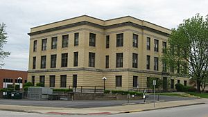
Pike County Courthouse in Petersburg
|
|

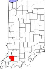
Location within the U.S. state of Indiana
|
|
 Indiana's location within the U.S. |
|
| Country | |
| State | |
| Founded | December 21, 1816 |
| Named for | Zebulon Pike |
| Seat | Petersburg |
| Largest city | Petersburg |
| Area | |
| • Total | 341.09 sq mi (883.4 km2) |
| • Land | 334.24 sq mi (865.7 km2) |
| • Water | 6.86 sq mi (17.8 km2) 2.01%% |
| Population
(2020)
|
|
| • Total | 12,250 |
| • Density | 35.914/sq mi (13.867/km2) |
| Time zone | UTC−5 (Eastern) |
| • Summer (DST) | UTC−4 (EDT) |
| Congressional district | 8th |
|
|
Pike County is a place in the southwest part of Indiana, a state in the United States. In 2020, about 12,250 people lived there. The main town, or county seat, is Petersburg. Pike County is special because in 2010, the exact middle point of the U.S. population was located there.
Pike County is also part of the Jasper area, which is a group of towns and cities that are connected economically.
Contents
History of Pike County
In 1787, the new United States created the Northwest Territory. This huge area included what is now Indiana. Later, in 1800, a part of this territory became the Indiana Territory. Thomas Jefferson, who was President, chose William Henry Harrison to be its first governor. The capital was set up in Vincennes.
Over time, more territories were formed, and Indiana became its current size. On December 11, 1816, Indiana officially became a state.
Land and Early Settlers
Before Indiana became a state, the U.S. government worked to get land from the Native American tribes. This happened through agreements and treaties, like the Treaty of 1804 and the Treaty of Fort Wayne in 1809. These agreements helped clear the way for new settlers in the area that would become Pike County. The first settlers started arriving around 1800.
How Pike County Was Formed
The area of Pike County was first part of Knox County in 1790. As more people moved in, this large county was divided into smaller ones. For example, Gibson County was created in 1813, and Warrick County was formed shortly after.
Then, on December 21, 1816, just ten days after Indiana became a state, the state government decided to create Pike County. It was made from parts of Gibson, Knox, and Perry counties. The first leaders of the county chose Petersburg as the county seat in 1817. The town was named after Peter Brenton, who owned the land where it was built. A post office opened in Petersburg in 1823.
Who Was Pike County Named After?
Pike County was named after Zebulon Pike. He was a famous explorer who led an expedition in 1806–1807 to explore the southwestern part of the Louisiana Purchase. He also fought in the War of 1812. He was a high-ranking officer when he died during a battle in Canada.
Courthouses of Pike County
The first courthouse in Pike County was a simple two-story building made of logs. It was built in Petersburg in 1817. Later, in 1834, a new two-story brick building replaced it. A third, even larger courthouse was built in 1868. The building that stands today was built in 1922.
Important People and Developments
From 1959 to 1963, two U.S. senators from Indiana, Vance Hartke and Homer E. Capehart, both came from Pike County. A U.S. Senator is a person elected to represent their state in the U.S. Congress, helping to make laws for the country.
In 2015, a new highway, Interstate 69, was completed in northern Pike County. This helped the local economy by making it easier for people and goods to travel.
Geography of Pike County
Pike County has low hills that have mostly been turned into farmland. However, many of the areas around rivers and streams are still covered in trees. The highest point in the county is about 650 feet (198 meters) above sea level, located northeast of Stendal.
Some parts of Pike County, especially near the Ohio River, used to have strip mines. This is where minerals are dug out from close to the surface. Most of these areas have been cleaned up and restored, but some still show signs of past mining.
The White River flows along the northern edge of the county. The Patoka River also flows through the middle part of the county and forms part of its western border with Gibson County.
Pike County covers about 341 square miles (883 square kilometers). Most of this area, about 334 square miles (865 square kilometers), is land, and the rest is water.
Neighboring Counties
- Daviess County – northeast
- Dubois County – east
- Warrick County – south
- Gibson County – west
- Knox County – northwest
Main Roads
Protected Natural Areas
- Columbia Mine Preserve (part)
- Interlake State Recreation Area (part)
- Patoka River National Wildlife Refuge and Management Area (part)
Cities and Towns
- Petersburg (the county seat)
Other Communities
- Alford
- Algiers
- Arda
- Arthur Junction
- Ashby Yards
- Augusta
- Ayrshire
- Bowman
- Campbelltown
- Cato
- Chandler
- Coats Spring
- Coe
- Enos Corner
- Fritz Corner
- Glezen
- Hartwell
- Highbank Town
- Iva
- Littles
- Marysville
- Muren
- Oatsville
- Pikeville
- Rogers
- Rumble
- Scottsburg
- Stendal
- Survant
- Union
- Velpen
- West Petersburg
- White Sulphur Springs
- Whiteoak
- Willisville
- Zoar
Townships
- Clay
- Jefferson
- Lockhart
- Logan
- Madison
- Marion
- Monroe
- Patoka
- Washington
Climate and Weather
| Weather chart for Petersburg, Indiana | |||||||||||||||||||||||||||||||||||||||||||||||
|---|---|---|---|---|---|---|---|---|---|---|---|---|---|---|---|---|---|---|---|---|---|---|---|---|---|---|---|---|---|---|---|---|---|---|---|---|---|---|---|---|---|---|---|---|---|---|---|
| J | F | M | A | M | J | J | A | S | O | N | D | ||||||||||||||||||||||||||||||||||||
|
3
38
21
|
2.7
44
25
|
4.1
54
33
|
4.2
66
44
|
5.1
75
54
|
3.8
83
63
|
4.2
87
67
|
3.8
86
65
|
3
80
57
|
2.8
69
45
|
4.5
55
36
|
3.4
43
26
|
||||||||||||||||||||||||||||||||||||
| temperatures in °F precipitation totals in inches source: The Weather Channel |
|||||||||||||||||||||||||||||||||||||||||||||||
|
Metric conversion
|
|||||||||||||||||||||||||||||||||||||||||||||||
The weather in Petersburg, Pike County, changes with the seasons. In January, the average low temperature is about 21°F (–6°C). In July, the average high temperature is about 87°F (31°C).
The coldest temperature ever recorded was -18°F (–28°C) in December 1989. The hottest was 101°F (38°C) in September 2002. The amount of rain and snow changes throughout the year. May usually gets the most precipitation, about 5.14 inches (131 mm). February is usually the driest, with about 2.73 inches (69 mm).
Population of Pike County
| Historical population | |||
|---|---|---|---|
| Census | Pop. | %± | |
| 1820 | 1,472 | — | |
| 1830 | 2,475 | 68.1% | |
| 1840 | 4,769 | 92.7% | |
| 1850 | 7,720 | 61.9% | |
| 1860 | 10,078 | 30.5% | |
| 1870 | 13,779 | 36.7% | |
| 1880 | 16,383 | 18.9% | |
| 1890 | 18,544 | 13.2% | |
| 1900 | 20,486 | 10.5% | |
| 1910 | 19,684 | −3.9% | |
| 1920 | 18,684 | −5.1% | |
| 1930 | 16,361 | −12.4% | |
| 1940 | 17,045 | 4.2% | |
| 1950 | 14,995 | −12.0% | |
| 1960 | 12,797 | −14.7% | |
| 1970 | 12,281 | −4.0% | |
| 1980 | 13,465 | 9.6% | |
| 1990 | 12,509 | −7.1% | |
| 2000 | 12,837 | 2.6% | |
| 2010 | 12,845 | 0.1% | |
| 2020 | 12,250 | −4.6% | |
| 2023 (est.) | 12,106 | −5.8% | |
| US Decennial Census 1790–1960 1900–1990 1990–2000 2010 |
|||
Pike County in 2010
In 2010, there were 12,845 people living in Pike County. They lived in 5,186 households, and 3,645 of these were families. On average, there were about 38 people per square mile.
Most of the people living in Pike County were white (98.2%). A small number were Black or African American (0.3%), Asian (0.2%), or American Indian (0.2%). About 0.9% of the population was of Hispanic or Latino background.
Many people in Pike County have ancestors from different places. For example, 25.7% said their background was American, 25.1% were German, 15.8% were Irish, and 11.4% were English.
About 29.6% of households had children under 18 living with them. Most households (57.3%) were married couples. The average household had 2.44 people.
The average income for a household in the county was about $47,697 per year. For families, it was about $49,423. About 12.9% of all people in the county lived below the poverty line. This means their income was below a certain level set by the government.
Education in Pike County
Pike County has one main school district called the Pike County School Corporation. This district runs Pike Central High School, which is the high school for the area.
See also
 In Spanish: Condado de Pike (Indiana) para niños
 | Victor J. Glover |
 | Yvonne Cagle |
 | Jeanette Epps |
 | Bernard A. Harris Jr. |

