Southwestern Indiana facts for kids
Quick facts for kids
Southwestern Indiana
|
|
|---|---|

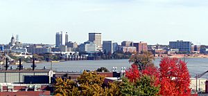
Evansville skyline
|
|

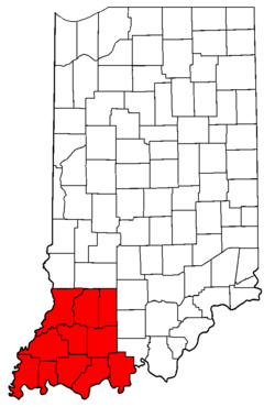
Counties of Southwestern Indiana
|
|
| Country | |
| State | |
| Largest city | Evansville |
| Population | 474,251 |
Southwestern Indiana is a special part of southern Indiana, United States. It's made up of 11 counties and is located at the very bottom and west side of the state. In 2010, about 474,251 people lived here.
Evansville is the biggest city in this area. It's also a main center for a larger region that includes parts of Kentucky and Illinois. Other important towns are Jasper, Vincennes, and Washington. Even though Indiana is a Midwestern state, Southwestern Indiana has a culture and way of speaking that feels more like the Upland South. It's a mix of Midwest and Southern influences!
Contents
Exploring Southwestern Indiana's Geography
The land in Southwestern Indiana is very interesting and changes a lot. You can find big forests, wet marshlands, rolling fields, and flat valleys. Towards the north and east, there are also low mountains, high hills, and sharp valleys.
Rivers and Waterways
Every county in Southwestern Indiana has a river as part of its border.
- The Wabash River runs along the west.
- The Ohio River forms the southern border.
- The White River splits into two parts, dividing the six northern counties.
- Many other smaller rivers are also important.
More than half of the borders for Daviess, Knox, Perry, Posey, and Spencer Counties are made by a river or creek. For Gibson and Pike counties, rivers make up almost half of their borders. Knox County is almost like a "river peninsula" because about 80% of its borders are rivers! A big part of this area is also in the Wabash Valley Seismic Zone, which means it's an area where earthquakes can happen.
City Layouts and History
Towns in Southwestern Indiana have different designs.
- Vincennes is laid out in a French style, with streets forming squares.
- Jasper and Princeton use a standard grid pattern.
- Evansville has both styles. Its downtown follows the river, while the rest of the city is a grid.
Southwestern Indiana is home to some of Indiana's oldest counties. Knox County is the very oldest county in the state! Gibson, Perry, Posey, and Warrick counties were even created before Indiana became a state. Pike County was the first county made after Indiana became a state. The newest county in this region is Martin County, created in 1820.
How Southwestern Indiana is Organized
Many Indiana state groups and businesses see Southwestern Indiana as one whole area. All the counties in Southwestern Indiana are part of Indiana's 8th Congressional District. Most of the area is also part of the Roman Catholic Diocese of Evansville, which is a church region. However, Perry County and a part of Spencer County belong to a different church region called the Archdiocese of Indianapolis.
This region is also known for its wine! The southern part of Southwestern Indiana is in the Ohio River Valley American Viticultural Area. This is the second-largest wine-growing area in the United States. It includes all of Perry, Posey, Spencer, Vanderburgh, and Warrick Counties, plus most of Gibson County, and parts of Pike and Dubois Counties.
Counties of Southwestern Indiana
Here's a look at the counties that make up Southwestern Indiana:
| IN No. |
County name |
Established date |
County seat |
Time zone |
Population (2015) |
Area sq mi (km2) |
Twps |
ZIP code Prefix(es) |
% of Boundary by water |
|---|---|---|---|---|---|---|---|---|---|
| 14 | Daviess | February 2, 1818 | Washington | Eastern | 32,906 | 437 sq mi (1,130 km2) | 10 | 475 | 55% |
| 19 | Dubois | December 20, 1817 | Jasper | Eastern | 42,461 | 435 sq mi (1,130 km2) | 12 | 475 | 24% |
| 26 | Gibson | April 1, 1813 | Princeton | Central | 33,775 | 526 sq mi (1,360 km2) | 10 | 475/476 | 59% |
| 42 | Knox | June 6, 1790 | Vincennes | Eastern | 37,927 | 516 sq mi (1,340 km2) | 10 | 475/478 | 84% |
| 51 | Martin | January 7, 1820 | Shoals | Eastern | 10,226 | 341 sq mi (880 km2) | 6 | 475 | 18% |
| 62 | Perry | November 1, 1814 | Tell City | Central | 19,347 | 386 sq mi (1,000 km2) | 7 | 474/475 | 52% |
| 63 | Pike | December 21, 1816 | Petersburg | Eastern | 12,594 | 342 sq mi (890 km2) | 9 | 475/476 | 35% |
| 65 | Posey | November 11, 1814 | Mt. Vernon | Central | 25,512 | 429 sq mi (1,110 km2) | 10 | 476 | 63% |
| 74 | Spencer | January 10, 1818 | Rockport | Central | 20,715 | 401 sq mi (1,040 km2) | 9 | 475/476 | 73% |
| 82 | Vanderburgh | January 7, 1818 | Evansville | Central | 181,877 | 236 sq mi (610 km2) | 8 | 476/477 | 26% |
| 87 | Warrick | April 30, 1813 | Boonville | Central | 61,897 | 424 sq mi (1,100 km2) | 10 | 475/476/477 | 19% |
Major Cities and Their Areas
Southwestern Indiana has several important city areas.
Evansville Metropolitan Area
The Evansville area is a large region that includes cities like Evansville, Henderson, and Princeton. It covers counties in both Indiana and Kentucky. In 2005, about 352,943 people lived here.
Smaller City Areas
There are also smaller city areas, called micropolitan areas:
- The Jasper area includes Jasper and Dubois and Pike counties.
- The Vincennes area includes Lawrenceville and Vincennes, covering parts of Illinois and Indiana.
- The Washington area is centered around Washington in Daviess County.
Highways in Southwestern Indiana
Interstate Highways
 Interstate 64: This older highway runs east to west. It's mostly flat in some counties but gets very hilly as it goes through Warrick County and towards Perry County.
 Interstate 69: This newer highway connects Evansville to Bloomington and eventually Indianapolis. It's flat near Evansville but becomes hilly in Gibson and Pike counties. Some parts in Daviess County are flatter, but it gets very hilly again as it leaves the area.
U.S. Highways
 U.S. Route 41: This four-lane highway goes all the way from Florida to Michigan. It passes through Evansville, becoming six lanes in some parts. It also goes around Princeton and Vincennes.
 U.S. Route 50: This highway stretches from Maryland to California. In Southwestern Indiana, it's a winding two-lane road in the east, but becomes four lanes near Washington. It joins US 41 near Vincennes and crosses into Illinois on the Red Skelton Bridge.
 U.S. Route 150: This road runs with US 50 from Vincennes to Shoals, then heads east on its own.
 U.S. Route 231: This highway is mostly new and has four lanes. It's being updated to connect Rockport to Greene County, where it will meet Interstate 69.
Fun Festivals and Celebrations
Southwestern Indiana has many exciting festivals and events throughout the year!
- April
- Perry County Dogwood Tour - Perry County, Indiana
- May
- Gastoff Spring Festival - Montgomery, Indiana
- Historic Newburgh Wine and Arts Festival - Newburgh, Indiana
- Spirit of Vincennes Rendezvous - Vincennes, Indiana
- June
- Spencer County Fair - Grandview, Indiana
- Haubstadt Somerfest - Haubstadt, Indiana
- Evansville Freedom Festival - Evansville, Indiana
- July
- Germania Männerchor Volksfest - Evansville, Indiana
- Thunder on the Ohio - Evansville, Indiana
- 4th of July Festival - Otwell, Indiana
- Gibson County Fair - Princeton, Indiana
- Cedar Valley Bluegrass Festival - Derby, Indiana
- Owensville Watermelon Festival - Owensville, Indiana
- St. Wendel Bierstube - St. Wendel, Indiana
- August
- Strassenfest - Jasper, Indiana
- Oakland City Sweetcorn Festival - Oakland City, Indiana
- Buffalo Trace Festival - Petersburg, Indiana
- Tell City Schweizer Fest - Tell City, Indiana
- Knox County Watermelon Festival - Bicknell, Indiana
- Princeton Golden Heritage Days - Princeton, Indiana
- Warrick County Fair - Boonville, Indiana
- Vanderburgh County Fair - Darmstadt, Indiana
- September
- Princeton Labor Day Celebration Princeton, Indiana
- Dale Fall Festival - Dale, Indiana
- Spirit of Vincennes Civil War Days - Vincennes, Indiana
- Fort Branch Fall Days - Fort Branch, Indiana
- Bear Hollow Fall Fest & Dasholz - St. Croix, Indiana
- Gastoff Fall Festival - Montgomery, Indiana
- Kunstfest - New Harmony, Indiana
- Poseyville Autumnfest - Poseyville, Indiana
- October
- West Side Nut Club Fall Festival - Evansville, Indiana
- Troy Pioneer Days - Troy, Indiana
- Spencer County Fair Octoberfest - Grandview, Indiana
- Hoosier Heritage Fall Tour - Perry County, Indiana
- Cannelton Heritage Festival - Cannelton, Indiana
- Rome Courthouse Days - Rome, Indiana
- Historic Newburgh Ghost Walks - Newburgh, Indiana
- Old Courthouse Catacombs - Old Vanderburgh County Courthouse
- November and December
- Muster on the Wabash (November) - Vincennes, Indiana (Fort Knox II)
- Santa Claus Christmas Celebration (December) - Santa Claus, Indiana
- Many towns have Thanksgiving and Christmas parades in November and December. There are also many basketball tournaments in December, like the Gibson County Toyota Teamwork Classic.
Time Zones: Central vs. Eastern
For many years, from 1966 to 2006, five counties in Southwestern Indiana (Gibson, Posey, Spencer, Vanderburgh, and Warrick) used Central Daylight Time. The other six counties (Daviess, Dubois, Knox, Martin, Perry, and Pike) stayed on Eastern Standard Time all year, like most of the rest of Indiana.
In 2006, the governor of Indiana, Mitch Daniels, made a new rule. He wanted all Indiana counties to use Daylight Time and switch to Eastern Daylight Time. This caused a lot of confusion in Southwestern and Northwestern Indiana. Counties started to decide if they wanted to go back to the Central Time Zone or stay in the Eastern Time Zone and start observing Daylight Time. On April 2, 2006, all of Southwestern Indiana ended up in the Central Time Zone.
But soon after, people started to complain. One big problem was that the Crane Naval Surface Warfare Center became a "time island." This meant its workers were on a different time than many nearby areas. The workers asked for Martin County to switch back to Eastern Time. This started a chain reaction, and many counties asked to go back to Eastern Time, including some that had been in the Central Time Zone.
On September 20, 2007, after only 15 months, the government decided to move only five of the eight counties back to the Eastern Time Zone. Gibson, Perry, and Spencer counties did not get enough support to switch. However, Daviess, Knox, and Pike counties were moved to Eastern Time because it was thought to be better for business. In Dubois County, there was a big debate between Huntingburg and Jasper. Huntingburg's economy was more connected to the Central Time Zone, while Jasper felt it was better for their businesses to be on Eastern Time. In the end, Daviess, Dubois, Knox, Martin, and Pike counties went back to the Eastern Time Zone on November 4, 2007. This meant Southwestern Indiana was divided by time zones once again.
 | Georgia Louise Harris Brown |
 | Julian Abele |
 | Norma Merrick Sklarek |
 | William Sidney Pittman |


