Knox County, Indiana facts for kids
Quick facts for kids
Knox County
|
|
|---|---|

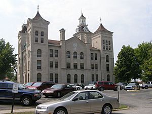
Knox County Courthouse, Vincennes
|
|

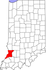
Location within the U.S. state of Indiana
|
|
 Indiana's location within the U.S. |
|
| Country | |
| State | |
| Founded | June 6, 1790 |
| Named for | Henry Knox |
| Seat | Vincennes |
| Largest city | Vincennes |
| Area | |
| • Total | 524.04 sq mi (1,357.3 km2) |
| • Land | 516.03 sq mi (1,336.5 km2) |
| • Water | 8.01 sq mi (20.7 km2) |
| Population
(2020)
|
|
| • Total | 36,282 |
| • Density | 69.2352/sq mi (26.7318/km2) |
| Time zone | UTC−5 (Eastern) |
| • Summer (DST) | UTC−4 (EDT) |
| Congressional district | 8th |
|
Indiana county number 42
|
|
Knox County is a special area in the state of Indiana, United States. It's the oldest county in Indiana! It was one of the first two counties made in the Northwest Territory way back in 1790. The other was St. Clair County, Illinois.
Over time, Knox County became smaller as new counties were formed. It got its current shape in 1818 when Daviess County was created from part of it. In 2020, about 36,282 people lived here. The main city and government center is Vincennes.
Knox County is also part of the Vincennes, IN Micropolitan Statistical Area, which is like a small city area with its nearby towns.
Contents
Discovering Knox County's Past
In 1790, a person named Winthrop Sargent, who was the Secretary of the Northwest Territory, officially created Knox County. It was the fourth county made in the Northwest Territory. The county was named after Major General Henry Knox. He had just finished his job as the second U.S. Secretary of War.
Knox County was formed even before the Indiana Territory was created. When it was first made, Knox County was huge! It stretched all the way to Canada. It included parts of what are now Indiana, Michigan, Illinois, and Ohio. Later, in 1809, when the Illinois Territory was formed, the parts of Knox County west of the Wabash River became Saint Clair County, Illinois.
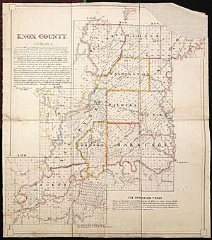
Many areas in Knox County were measured using an old French system. This system uses directions that are not exactly north, south, east, or west. Knox County and Clark County are the only places in Indiana that were laid out this way.
Exploring Knox County's Geography
Knox County is located on the western side of Indiana. Its western border is the Wabash River, which also forms the border with Illinois. In 2010, the county had a total area of about 524 square miles. Most of this area, about 516 square miles, is land. The rest, about 8 square miles, is water.
The Wabash River flows south along the county's western edge. The White River flows south-southwest along its eastern edge. The two rivers meet at the very southwestern tip of the county, near Mount Carmel, Illinois. The land in Knox County has green, gently rolling hills. Much of this land is used for farming. The highest points in the county are around 620 feet above sea level. These high spots are found in the hills between Bruceville and Bicknell.
Main Roads in Knox County
Knox County has several important roads that help people travel around.
- US 41
- US 50
- US 150
- SR 58
- SR 59
- SR 61
- SR 67
- SR 159
- SR 241
- SR 358
- SR 441
- SR 550
Neighboring Counties
Knox County shares its borders with several other counties:
- To the north: Sullivan County
- To the northeast: Greene County
- To the east: Daviess County
- To the southeast: Pike County
- To the south: Gibson County
- To the southwest: Wabash County, Illinois (in Illinois)
- To the west: Lawrence County, Illinois (in Illinois)
- To the northwest: Crawford County, Illinois (in Illinois)
Protected Natural Areas
Knox County is home to one national protected area:
Communities of Knox County
Knox County has different types of communities, from cities to small towns and even tiny settlements.
Cities in Knox County
Towns in Knox County
Census-Designated Places
These are areas that are like towns but are not officially incorporated as cities or towns.
Unincorporated Areas
These are smaller communities that don't have their own local government.
- Beal
- Busseron
- Fritchton
- Indian Creek Settlement
- Iona
- Little Rock
- Orrville
- Pond Creek Mills
- Purcell
- Saint Thomas
- Verne
- Wagner Station
- Willis
Townships of Knox County
Knox County is divided into several townships, which are smaller local government areas.
- Busseron
- Decker
- Harrison
- Johnson
- Palmyra
- Steen
- Vigo
- Vincennes
- Washington
- Widner
Climate and Weather in Knox County
| Weather chart for Vincennes, Indiana | |||||||||||||||||||||||||||||||||||||||||||||||
|---|---|---|---|---|---|---|---|---|---|---|---|---|---|---|---|---|---|---|---|---|---|---|---|---|---|---|---|---|---|---|---|---|---|---|---|---|---|---|---|---|---|---|---|---|---|---|---|
| J | F | M | A | M | J | J | A | S | O | N | D | ||||||||||||||||||||||||||||||||||||
|
2.6
38
20
|
2.5
43
23
|
3.6
53
32
|
4.3
65
42
|
5.1
75
52
|
4.1
84
61
|
4.7
88
65
|
3.7
86
63
|
3.2
80
54
|
3.2
68
42
|
4.3
54
33
|
3.2
43
25
|
||||||||||||||||||||||||||||||||||||
| temperatures in °F precipitation totals in inches source: The Weather Channel |
|||||||||||||||||||||||||||||||||||||||||||||||
|
Metric conversion
|
|||||||||||||||||||||||||||||||||||||||||||||||
The weather in Vincennes, the main city in Knox County, changes with the seasons. In January, the average low temperature is about 20°F. In July, the average high temperature reaches about 88°F.
However, temperatures can be extreme! The coldest temperature ever recorded in January was -26°F in 1994. The hottest was 104°F in June 1988. The amount of rain also changes throughout the year. February usually gets the least rain, about 2.51 inches. May typically gets the most, with about 5.13 inches.
People of Knox County
| Historical population | |||
|---|---|---|---|
| Census | Pop. | %± | |
| 1800 | 2,517 | — | |
| 1810 | 7,945 | 215.7% | |
| 1820 | 5,437 | −31.6% | |
| 1830 | 6,525 | 20.0% | |
| 1840 | 10,657 | 63.3% | |
| 1850 | 11,084 | 4.0% | |
| 1860 | 16,056 | 44.9% | |
| 1870 | 21,562 | 34.3% | |
| 1880 | 26,324 | 22.1% | |
| 1890 | 28,044 | 6.5% | |
| 1900 | 32,746 | 16.8% | |
| 1910 | 39,183 | 19.7% | |
| 1920 | 46,195 | 17.9% | |
| 1930 | 43,813 | −5.2% | |
| 1940 | 43,973 | 0.4% | |
| 1950 | 43,415 | −1.3% | |
| 1960 | 41,561 | −4.3% | |
| 1970 | 41,546 | 0.0% | |
| 1980 | 41,838 | 0.7% | |
| 1990 | 39,884 | −4.7% | |
| 2000 | 39,256 | −1.6% | |
| 2010 | 38,440 | −2.1% | |
| 2020 | 36,282 | −5.6% | |
| 2023 (est.) | 36,070 | −6.2% | |
| US Decennial Census 1790-1960 1900-1990 1990-2000 2010 |
|||
In 2010, there were 38,440 people living in Knox County. These people lived in over 15,000 homes. The population density was about 74.5 people per square mile. Most of the people were white (94.9%). About 2.6% were black or African American, and 0.6% were Asian.
About 29.1% of homes had children under 18 living there. The average age of people in the county was 38.5 years old. The average income for a household was about $47,697 per year. About 16.4% of all people in the county lived below the poverty line. This included 22.7% of those under 18.
Jobs and Economy in Knox County
In 2005, Knox County had many businesses and jobs. The biggest industry for jobs was education and health services. This means many people worked in schools, colleges, and hospitals. This industry made up almost 34% of all jobs.
The next biggest industry was trade, transportation, and utilities. This included jobs in stores, shipping, and power companies. Manufacturing, which means making things in factories, also grew a lot. It added over 300 new jobs between 2001 and 2005.
The average yearly earnings for jobs in Knox County in 2005 was about $26,875. Jobs in manufacturing had the highest average earnings, around $33,238 per year. The Vincennes area has many different types of jobs. Retail trade, like working in shops, was the largest sector in 2005.
Knox County also has a special "Pathways Program." This program helps make sure there are skilled and motivated workers. Many businesses in the area can find employees from within a 50-mile drive. This is because it's easy to get to Vincennes from nearby counties.
See also
 In Spanish: Condado de Knox (Indiana) para niños
 | Shirley Ann Jackson |
 | Garett Morgan |
 | J. Ernest Wilkins Jr. |
 | Elijah McCoy |


