
Crawford County, Illinois facts for kids
Quick facts for kids
Crawford County
|
|
|---|---|

Crawford County Courthouse in Robinson
|
|

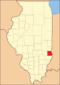
Location within the U.S. state of Illinois
|
|
 Illinois's location within the U.S. |
|
| Country | |
| State | |
| Founded | 1816 |
| Named for | William H. Crawford |
| Seat | Robinson |
| Largest city | Robinson |
| Area | |
| • Total | 446 sq mi (1,160 km2) |
| • Land | 444 sq mi (1,150 km2) |
| • Water | 2.2 sq mi (6 km2) 0.5% |
| Population
(2020)
|
|
| • Total | 18,679 |
| • Density | 41.88/sq mi (16.170/km2) |
| Time zone | UTC−6 (Central) |
| • Summer (DST) | UTC−5 (CDT) |
| Congressional district | 12th |
Crawford County is a county in the state of Illinois, USA. In 2020, about 18,679 people lived there. The main town and county seat (where the county government is) is Robinson.
Contents
History
Crawford County was created on December 31, 1816. This was when Illinois was still a territory, before it became a state. When it was first formed, the county was very large. It covered about one-third of what is now Illinois!
Over time, new counties were made from parts of Crawford County. By 1831, it had shrunk to its current size. The county was named after William H. Crawford. He was an important person from Georgia. At the time, he was serving as the Secretary of War and Secretary of the Treasury. These were big jobs in the U.S. government.
In the early days, there were some conflicts between the settlers and Native American groups in the area.
-
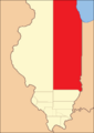
Crawford County when it was first created in 1816. It stretched far north!
-
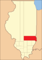
Crawford County between 1819 and 1821.
-
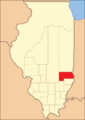
Crawford County between 1821 and 1824.
-
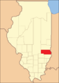
Crawford County between 1824 and 1831.
-
By 1831, new counties like Jasper and Effingham were formed. This made Crawford County its current size.


In 1818, the town of Palestine was chosen as the first county seat. But later, in 1843, a new place was picked. This new place grew into the town of Robinson, which is still the county seat today.
Geography
Crawford County covers a total area of 446 square miles (1,160 km2). Most of this area, about 444 square miles (1,150 km2), is land. The rest, about 2.2 square miles (5.7 km2), is water. Part of the county's eastern border is formed by the Wabash River.
Climate and weather
| Weather chart for Robinson, Illinois | |||||||||||||||||||||||||||||||||||||||||||||||
|---|---|---|---|---|---|---|---|---|---|---|---|---|---|---|---|---|---|---|---|---|---|---|---|---|---|---|---|---|---|---|---|---|---|---|---|---|---|---|---|---|---|---|---|---|---|---|---|
| J | F | M | A | M | J | J | A | S | O | N | D | ||||||||||||||||||||||||||||||||||||
|
2.5
37
21
|
2.6
44
26
|
3.8
55
35
|
4
66
44
|
4.7
77
54
|
3.8
85
64
|
4.2
89
67
|
3.8
87
65
|
3.5
81
57
|
3
69
45
|
3.9
54
37
|
3.2
42
26
|
||||||||||||||||||||||||||||||||||||
| temperatures in °F precipitation totals in inches source: The Weather Channel |
|||||||||||||||||||||||||||||||||||||||||||||||
|
Metric conversion
|
|||||||||||||||||||||||||||||||||||||||||||||||
The weather in Robinson, the county seat, changes a lot throughout the year. In January, the average low temperature is about 21 °F (−6 °C). In July, the average high temperature is around 89 °F (32 °C).
The coldest temperature ever recorded was −23 °F (−31 °C) in December 1989. The hottest was 114 °F (46 °C) in July 1954. The county also gets rain throughout the year. The average monthly rainfall ranges from 2.45 inches (62 mm) in January to 4.67 inches (119 mm) in May.
Neighboring Counties
Crawford County shares borders with several other counties:
- Clark County - to the north
- Sullivan County, Indiana - to the east
- Knox County, Indiana - to the southeast
- Lawrence County - to the south
- Richland County - to the southwest
- Jasper County - to the west
Main Roads
These are the major highways that go through Crawford County:
 Illinois Route 1
 Illinois Route 33
Population Information
| Historical population | |||
|---|---|---|---|
| Census | Pop. | %± | |
| 1820 | 3,022 | — | |
| 1830 | 3,117 | 3.1% | |
| 1840 | 4,422 | 41.9% | |
| 1850 | 7,135 | 61.4% | |
| 1860 | 11,551 | 61.9% | |
| 1870 | 13,889 | 20.2% | |
| 1880 | 16,197 | 16.6% | |
| 1890 | 17,283 | 6.7% | |
| 1900 | 19,240 | 11.3% | |
| 1910 | 26,281 | 36.6% | |
| 1920 | 22,771 | −13.4% | |
| 1930 | 21,085 | −7.4% | |
| 1940 | 21,294 | 1.0% | |
| 1950 | 21,137 | −0.7% | |
| 1960 | 20,751 | −1.8% | |
| 1970 | 19,824 | −4.5% | |
| 1980 | 20,818 | 5.0% | |
| 1990 | 19,464 | −6.5% | |
| 2000 | 20,452 | 5.1% | |
| 2010 | 19,817 | −3.1% | |
| 2020 | 18,679 | −5.7% | |
| 2023 (est.) | 18,300 | −7.7% | |
| U.S. Decennial Census 1790-1960 1900-1990 1990-2000 2010 |
|||

In 2010, there were 19,817 people living in Crawford County. There were 7,763 households, which are groups of people living together. Out of these, 5,154 were families.
The average number of people in a household was 2.36. For families, it was 2.88 people. The average age of people in the county was 41.7 years old.
Many different backgrounds make up the county's population. For example, in 2010, about 25% of people had German roots. About 14.4% had American roots, 12.4% had Irish roots, and 9.9% had English roots.
Communities
Crawford County has several towns and villages:
Cities
Villages
Census-designated places
These are areas that are like towns but are not officially incorporated as cities or villages.
Townships
Crawford County is divided into ten smaller areas called townships:
- Honey Creek
- Hutsonville
- Lamotte
- Licking
- Martin
- Montgomery
- Oblong
- Prairie
- Robinson
- Southwest
See also
 In Spanish: Condado de Crawford (Illinois) para niños
