
Clark County, Illinois facts for kids
Quick facts for kids
Clark County
|
|
|---|---|

Clark County Courthouse in Marshall
|
|

Location within the U.S. state of Illinois
|
|
 Illinois's location within the U.S. |
|
| Country | |
| State | |
| Founded | 1819 |
| Named for | George Rogers Clark |
| Seat | Marshall |
| Largest city | Marshall |
| Area | |
| • Total | 505 sq mi (1,310 km2) |
| • Land | 501 sq mi (1,300 km2) |
| • Water | 3.4 sq mi (9 km2) 0.7% |
| Population
(2020)
|
|
| • Total | 15,455 |
| • Density | 30.604/sq mi (11.816/km2) |
| Time zone | UTC−6 (Central) |
| • Summer (DST) | UTC−5 (CDT) |
| Congressional district | 12th |
Clark County is a place in the southeastern part of Illinois. It's right next to the state of Indiana. In 2020, about 15,455 people lived here. The main town, or county seat, is Marshall. The county got its name from George Rogers Clark, a brave officer from the American Revolution.
Contents
History of Clark County
Clark County was created in 1819 from Crawford County. When it first started, Clark County was huge! It covered about one-third of Illinois and even reached as far north as what is now Wisconsin.
Over the years, parts of Clark County became new counties:
- In 1821, the northern part became Pike County.
- Also in 1821, the western part became Fayette County.
- In 1823, Edgar County was formed from the northern part.
- In 1830, Coles County took more land from the west.
Since 1830, the borders of Clark County have stayed the same.
Clark County was named after George Rogers Clark. He was a military officer from Virginia. During the American Revolutionary War, he helped capture the Northwest Territory from the British. Fun fact: he was the older brother of William Clark, who was famous for the Lewis and Clark Expedition!
-
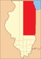
Clark County from the time of its creation to 1821
-
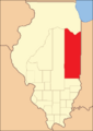
Clark between 1821 and 1823
-
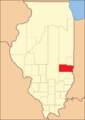
Clark between 1823 and 1830
-
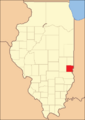
Clark reduced to its current size in 1830 by the creation of Coles County


The county seat (the main government town) was first in Darwin Township in 1823. But in 1839, people voted to move it. They chose between Auburn and Marshall. Marshall won the vote and has been the county seat ever since.
Geography of Clark County
Clark County covers about 505 square miles. Most of this is land (501 square miles), and a small part (3.4 square miles) is water.
The Wabash River forms part of the county's eastern border. Other important rivers and creeks include the North Fork of the Embarras River and Hurricane Creek in the west. Big Creek is also a major stream in the eastern part of the county.
Neighboring Counties
Clark County shares borders with these counties:
- Edgar County to the north
- Vigo County, Indiana to the northeast
- Sullivan County, Indiana to the southeast
- Crawford County to the south
- Jasper County to the southwest
- Cumberland County to the west
- Coles County to the northwest
Main Roads
You can travel through Clark County on these major highways:
 Interstate 70
 U.S. Route 40
 Illinois Route 1
 Illinois Route 49
Climate and Weather
| Weather chart for Marshall, Illinois | |||||||||||||||||||||||||||||||||||||||||||||||
|---|---|---|---|---|---|---|---|---|---|---|---|---|---|---|---|---|---|---|---|---|---|---|---|---|---|---|---|---|---|---|---|---|---|---|---|---|---|---|---|---|---|---|---|---|---|---|---|
| J | F | M | A | M | J | J | A | S | O | N | D | ||||||||||||||||||||||||||||||||||||
|
2.2
34
16
|
2.2
40
21
|
3.3
51
31
|
4
63
41
|
4.3
74
51
|
4.2
83
61
|
4.4
86
65
|
4.4
84
62
|
2.9
78
55
|
2.8
66
43
|
3.7
51
33
|
3.1
39
22
|
||||||||||||||||||||||||||||||||||||
| temperatures in °F precipitation totals in inches source: The Weather Channel |
|||||||||||||||||||||||||||||||||||||||||||||||
|
Metric conversion
|
|||||||||||||||||||||||||||||||||||||||||||||||
In Marshall, the county seat, temperatures usually range from about 16°F (that's cold!) in January to 86°F (that's hot!) in July. The coldest temperature ever recorded was -23°F in January 1930. The hottest was 109°F in July 1936.
The amount of rain and snow changes throughout the year. It's usually lowest in January (about 2.23 inches) and highest in July (about 4.43 inches).
People of Clark County (Demographics)
| Historical population | |||
|---|---|---|---|
| Census | Pop. | %± | |
| 1820 | 931 | — | |
| 1830 | 3,940 | 323.2% | |
| 1840 | 7,453 | 89.2% | |
| 1850 | 9,532 | 27.9% | |
| 1860 | 14,987 | 57.2% | |
| 1870 | 18,709 | 24.8% | |
| 1880 | 21,894 | 17.0% | |
| 1890 | 21,899 | 0.0% | |
| 1900 | 24,033 | 9.7% | |
| 1910 | 23,517 | −2.1% | |
| 1920 | 21,165 | −10.0% | |
| 1930 | 17,872 | −15.6% | |
| 1940 | 18,842 | 5.4% | |
| 1950 | 17,362 | −7.9% | |
| 1960 | 16,546 | −4.7% | |
| 1970 | 16,216 | −2.0% | |
| 1980 | 16,913 | 4.3% | |
| 1990 | 15,921 | −5.9% | |
| 2000 | 17,008 | 6.8% | |
| 2010 | 16,335 | −4.0% | |
| 2020 | 15,455 | −5.4% | |
| 2023 (est.) | 15,088 | −7.6% | |
| U.S. Decennial Census 1790-1960 1900-1990 1990-2000 2010 |
|||

In 2010, there were 16,335 people living in Clark County. The population density was about 32.6 people per square mile. Most people (98.1%) were white. A small number were black, Asian, or American Indian. About 1.1% of the population was of Hispanic or Latino background.
Many people in Clark County have German (27.4%), Irish (14.2%), or English (14.2%) family backgrounds.
About 30.3% of households had children under 18 living with them. The average age of people in the county was 42.3 years old.
The average yearly income for a household in the county was about $43,597. For families, it was about $52,689. About 10.9% of all people in the county lived below the poverty line. This included 15.3% of kids under 18.
Education
Clark County has three school districts: Marshall, Martinsville, and Casey-Westfield. In 2004, about 3,014 students were enrolled in these schools. Each district has one high school (grades 9–12) and one junior high school (grades 7–8). Marshall has two elementary schools, while the other districts each have one.
See List of school districts in Clark County
Communities in Clark County
Here are some of the towns and communities you can find in Clark County:
Cities
- Casey
- Marshall (This is the county seat!)
- Martinsville
Village
Census Designated Places
Small Communities (Unincorporated)
Townships
Clark County is divided into fifteen areas called townships:
- Anderson
- Auburn
- Casey
- Darwin
- Dolson
- Douglas
- Johnson
- Marshall
- Martinsville
- Melrose
- Orange
- Parker
- Wabash
- Westfield
- York
Former Settlement
See also
 In Spanish: Condado de Clark (Illinois) para niños
