
Fayette County, Illinois facts for kids
Quick facts for kids
Fayette County
|
|
|---|---|

Fayette County Courthouse in Vandalia
|
|

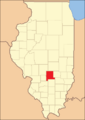
Location within the U.S. state of Illinois
|
|
 Illinois's location within the U.S. |
|
| Country | |
| State | |
| Founded | 1821 |
| Named for | Marquis de Lafayette |
| Seat | Vandalia |
| Largest city | Vandalia |
| Area | |
| • Total | 725 sq mi (1,880 km2) |
| • Land | 716 sq mi (1,850 km2) |
| • Water | 8.9 sq mi (23 km2) 1.2% |
| Population
(2020)
|
|
| • Total | 21,488 |
| • Density | 29.639/sq mi (11.444/km2) |
| Time zone | UTC−6 (Central) |
| • Summer (DST) | UTC−5 (CDT) |
| Congressional district | 15th |
Fayette County is a county in the state of Illinois, USA. In 2020, about 21,488 people lived here. The main city and county seat is Vandalia. This city is also home to the Vandalia State House State Historic Site, which is a cool place to visit. You can also find the Ramsey Lake State Recreation Area in the northwest part of the county, which is great for outdoor fun!
Contents
History
Fayette County was created in 1821. It was formed from parts of Bond, Clark, and Crawford counties. The county was named after the Marquis de LaFayette. He was a French hero who helped America during the American Revolutionary War.
Over the years, parts of Fayette County were used to create other counties. In 1823, Marion County, Illinois was formed from its southern part. Later, Clay, Clinton, and Shelby Counties were also created from Fayette County areas. Even early Tazewell County got some land from here. Finally, in 1831, Effingham County was created. This set the borders for Fayette County as they are today.
-
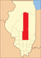
Fayette County between the time of its creation and 1823
-
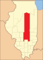
Fayette between 1823 and 1824
-
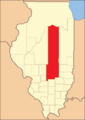
Fayette between 1824 and 1827
-
Fayette between 1827 and 1831
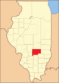
-
Fayette in 1831, when the creation of Effingham County reduced it to its current size


Geography
Fayette County covers a total area of about 725 square miles. Most of this area, about 716 square miles, is land. The remaining 8.9 square miles, or 1.2%, is water.
Climate and Weather
| Weather chart for Vandalia, Illinois | |||||||||||||||||||||||||||||||||||||||||||||||
|---|---|---|---|---|---|---|---|---|---|---|---|---|---|---|---|---|---|---|---|---|---|---|---|---|---|---|---|---|---|---|---|---|---|---|---|---|---|---|---|---|---|---|---|---|---|---|---|
| J | F | M | A | M | J | J | A | S | O | N | D | ||||||||||||||||||||||||||||||||||||
|
2.5
35
18
|
2.4
41
23
|
3.7
52
32
|
3.6
64
43
|
4.1
74
53
|
3.9
83
62
|
3.6
88
67
|
2.8
86
64
|
3
79
55
|
2.8
67
43
|
3.7
53
34
|
2.8
40
24
|
||||||||||||||||||||||||||||||||||||
| temperatures in °F precipitation totals in inches source: The Weather Channel |
|||||||||||||||||||||||||||||||||||||||||||||||
|
Metric conversion
|
|||||||||||||||||||||||||||||||||||||||||||||||
The weather in Vandalia, the county seat, changes throughout the year. In January, the average low temperature is about 18°F. In July, the average high temperature is around 88°F. The coldest temperature ever recorded was -21°F in January 1985. The hottest was 104°F in July 1980. The county usually gets the most rain in May, with about 4.11 inches. February is the driest month, with about 2.41 inches of rain.
Neighboring Counties
Fayette County shares its borders with several other counties:
- Shelby County - to the northeast
- Effingham County - to the east
- Clay County - to the southeast
- Marion County - to the south
- Clinton County - to the southwest
- Bond County - to the west
- Montgomery County - to the northwest
Main Roads
Several important highways pass through Fayette County:
 Interstate 57
 Interstate 70
 U.S. Route 40
 U.S. Route 51
 Illinois Route 33
 Illinois Route 37
 Illinois Route 128
 Illinois Route 140
 Illinois Route 185
Population Information
| Historical population | |||
|---|---|---|---|
| Census | Pop. | %± | |
| 1830 | 2,704 | — | |
| 1840 | 6,328 | 134.0% | |
| 1850 | 8,075 | 27.6% | |
| 1860 | 11,189 | 38.6% | |
| 1870 | 19,638 | 75.5% | |
| 1880 | 23,241 | 18.3% | |
| 1890 | 23,367 | 0.5% | |
| 1900 | 28,065 | 20.1% | |
| 1910 | 28,075 | 0.0% | |
| 1920 | 26,187 | −6.7% | |
| 1930 | 23,487 | −10.3% | |
| 1940 | 29,159 | 24.1% | |
| 1950 | 24,582 | −15.7% | |
| 1960 | 21,946 | −10.7% | |
| 1970 | 20,752 | −5.4% | |
| 1980 | 22,167 | 6.8% | |
| 1990 | 20,893 | −5.7% | |
| 2000 | 21,802 | 4.4% | |
| 2010 | 22,140 | 1.6% | |
| 2020 | 21,488 | −2.9% | |
| 2023 (est.) | 21,164 | −4.4% | |
| U.S. Decennial Census 1790-1960 1900-1990 1990-2000 2010 |
|||
In 2010, Fayette County had 22,140 people living there. Most of the people were white (93.7%). There were also black or African American people (4.4%), Asian people (0.2%), and American Indian people (0.2%). About 1.4% of the population was of Hispanic or Latino background. Many residents have German, English, American, or Irish family roots.
Communities
Cities
Villages
Unincorporated Communities
These are smaller places that are not officially cities or villages:
Townships
Fayette County is divided into twenty smaller areas called townships:
- Avena
- Bear Grove
- Bowling Green
- Carson
- Hurricane
- Kaskaskia
- LaClede
- Lone Grove
- Loudon
- Otego
- Pope
- Ramsey
- Sefton
- Seminary
- Shafter
- Sharon
- South Hurricane
- Vandalia
- Wheatland
- Wilberton
See also
 In Spanish: Condado de Fayette (Illinois) para niños
