St. Elmo, Illinois facts for kids
Quick facts for kids
St. Elmo
|
|
|---|---|

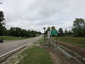
St. Elmo sign on Interstate Drive north of I-70.
|
|

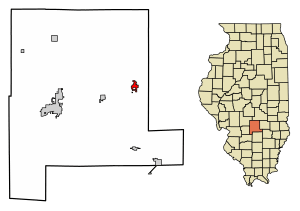
Location of St. Elmo in Fayette County, Illinois.
|
|

Location of Illinois in the United States
|
|
| Country | United States |
| State | Illinois |
| County | Fayette |
| Area | |
| • Total | 1.51 sq mi (3.90 km2) |
| • Land | 1.48 sq mi (3.84 km2) |
| • Water | 0.02 sq mi (0.06 km2) |
| Elevation | 614 ft (187 m) |
| Population
(2020)
|
|
| • Total | 1,254 |
| • Density | 845.58/sq mi (326.46/km2) |
| Time zone | UTC-6 (CST) |
| • Summer (DST) | UTC-5 (CDT) |
| ZIP Code(s) |
62458
|
| Area code(s) | 618 |
| FIPS code | 17-66794 |
| GNIS feature ID | 2396486 |
| Wikimedia Commons | St. Elmo, Illinois |
St. Elmo is a small city located in Fayette County, Illinois, in the United States. In 2020, about 1,254 people lived there. The city was founded a long time ago, in 1871.
Contents
Exploring St. Elmo's Location
St. Elmo is found at specific geographic coordinates: 39.026709 degrees North and 88.852062 degrees West. This helps pinpoint its exact spot on a map.
Land and Water Area
The city covers a total area of about 1.51 square miles (3.90 square kilometers). Most of this area, about 1.48 square miles (3.84 square kilometers), is land. A small part, around 0.02 square miles (0.06 square kilometers), is water.
A Look at St. Elmo's Past
St. Elmo has an interesting history, especially with important roads and railroads.
The National Road and Early Settlement
In 1806, President Thomas Jefferson approved a plan to build the National Road. This road stretched from Maryland all the way west to the Mississippi River. It was built to help pioneers travel and settle new areas. Today, U.S. Route 40 follows the path of this historic road through Illinois.
An early settlement called Howard's Point was created along the National Road where St. Elmo is now. Later, its name was changed to St. Elmo.
Railroad Connections
The name change happened around 1882 when a new north-south railroad was planned to end at the settlement. Even though that specific railroad didn't go through the town, an east-west railroad was built by 1895. This new railroad connected St. Elmo with nearby Vandalia. The town also built its own rail link to another railroad line, the Chicago, Paducah and Memphis Railroad.
Smith Aviation Field and the Oil Boom
In 1926, Smith Aviation Field was built on the west side of St. Elmo. This airfield became a popular spot for exciting air shows, featuring stunt flying, people walking on airplane wings, and parachute jumping. Famous pilot Charles Lindbergh was known to visit often.
In the late 1930s, a lot of oil was discovered nearby. This oil boom made St. Elmo so busy with oil companies that it was nicknamed "Little Tulsa." Many oil company leaders would fly into Smith Aviation Field, which is no longer used today.
Who Lives in St. Elmo?
Let's look at the population changes and how people live in St. Elmo.
Population Over the Years
The number of people living in St. Elmo has changed over time. Here's a quick look:
- 1870: 273 people
- 1900: 1,050 people
- 1940: 2,290 people (the highest recorded population)
- 2020: 1,254 people
Recent Population Details (2020)
According to the 2020 census, St. Elmo had 1,254 residents living in 534 households. About 372 of these households were families. The city had about 832 people per square mile.
Most residents, about 96.73%, identified as White. A small percentage were from other racial backgrounds or two or more races. About 1.28% of the population identified as Hispanic or Latino.
Households and Families
- About 26% of households had children under 18 living with them.
- Nearly half (48.13%) of households were married couples.
- About 14.79% of households were led by a female without a husband present.
- About 15.17% of households had someone living alone who was 65 or older.
Age Groups
The median age in St. Elmo was 40.3 years.
- About 24.1% of the population was under 18 years old.
- About 17.3% of the population was 65 years or older.
Income Information
In 2020, the average income for a household in St. Elmo was about $43,913. For families, the average income was around $50,662. The average income per person in the city was $19,890. About 22.1% of all people in St. Elmo lived below the poverty line. This included 51% of children under 18.
Learning in St. Elmo
St. Elmo has its own school district, St. Elmo Community School District #202.
Local Schools
The district includes two main schools:
- St. Elmo Elementary School: Located at 519 West 2nd Street.
- St. Elmo Jr/Sr High School: Found at the northern edge of town, at 300 West 12th Street.
See also
 In Spanish: St. Elmo (Illinois) para niños
 | William L. Dawson |
 | W. E. B. Du Bois |
 | Harry Belafonte |

