
Clinton County, Illinois facts for kids
Quick facts for kids
Clinton County
|
|
|---|---|

Clinton County Courthouse
|
|

Location within the U.S. state of Illinois
|
|
 Illinois's location within the U.S. |
|
| Country | |
| State | |
| Founded | 1824 |
| Named for | DeWitt Clinton |
| Seat | Carlyle |
| Largest city | Breese |
| Area | |
| • Total | 503 sq mi (1,300 km2) |
| • Land | 474 sq mi (1,230 km2) |
| • Water | 29 sq mi (80 km2) 5.8% |
| Population
(2020)
|
|
| • Total | 36,899 |
| • Estimate
(2023)
|
36,785 |
| • Density | 73.36/sq mi (28.324/km2) |
| Time zone | UTC−6 (Central) |
| • Summer (DST) | UTC−5 (CDT) |
| Congressional district | 12th |
Clinton County is a place in the state of Illinois, USA. In 2020, about 36,899 people lived there. The main town, or county seat, is Carlyle. Clinton County is also part of the larger St. Louis area, which includes parts of both Missouri and Illinois.
Contents
History of Clinton County
Long ago, in 1805, a special road was made through this area. It connected the capital of the Indiana Territory to St. Louis, Missouri. Later, in 1808, a wagon road was built. This road helped people travel and cross the Kaskaskia River at Carlyle.
People started settling in Clinton County by 1814. The county itself was officially created on December 27, 1824. It was formed from parts of other nearby counties. The county was named after DeWitt Clinton. He was the seventh Governor of New York and helped build the famous Erie Canal.
Crossing the Kaskaskia River became much easier in 1859. That's when the General Dean Suspension Bridge was built. Before the bridge, people had to use a ferry or a simple "mud bridge." In 1953, the bridge was named after William F. Dean.
Geography and Nature
Clinton County covers about 503 square miles. Most of this area is land, but about 29 square miles is water. You can find some nice parks here, like Eldon Hazlet State Recreation Area and South Shore State Park. The Kaskaskia River forms the southern border of the county.
Weather and Climate
| Weather chart for Carlyle, Illinois | |||||||||||||||||||||||||||||||||||||||||||||||
|---|---|---|---|---|---|---|---|---|---|---|---|---|---|---|---|---|---|---|---|---|---|---|---|---|---|---|---|---|---|---|---|---|---|---|---|---|---|---|---|---|---|---|---|---|---|---|---|
| J | F | M | A | M | J | J | A | S | O | N | D | ||||||||||||||||||||||||||||||||||||
|
2.2
36
19
|
2.4
43
23
|
3.8
54
33
|
3.9
65
43
|
4.2
75
53
|
4.4
84
62
|
3.7
88
67
|
2.8
86
65
|
3.1
79
57
|
3
68
45
|
3.8
54
35
|
3.2
42
24
|
||||||||||||||||||||||||||||||||||||
| temperatures in °F precipitation totals in inches source: The Weather Channel |
|||||||||||||||||||||||||||||||||||||||||||||||
|
Metric conversion
|
|||||||||||||||||||||||||||||||||||||||||||||||
The weather in Carlyle, the county seat, changes throughout the year. In January, the average low temperature is about 19°F (around -7°C). In July, the average high temperature is about 88°F (around 31°C). The county gets the most rain in June.
How to Get Around (Transit)
- South Central Transit
Main Roads and Highways
 Interstate 64
 US Route 50
 Illinois Route 127
 Illinois Route 160
 Illinois Route 161
 Illinois Route 177
Neighboring Counties
- Bond County - north
- Fayette County - northeast
- Madison County - northwest
- Marion County - east
- St. Clair County - west
- Washington County - south
People of Clinton County (Demographics)
| Historical population | |||
|---|---|---|---|
| Census | Pop. | %± | |
| 1830 | 2,330 | — | |
| 1840 | 3,718 | 59.6% | |
| 1850 | 5,139 | 38.2% | |
| 1860 | 10,941 | 112.9% | |
| 1870 | 16,285 | 48.8% | |
| 1880 | 18,714 | 14.9% | |
| 1890 | 17,411 | −7.0% | |
| 1900 | 19,824 | 13.9% | |
| 1910 | 22,832 | 15.2% | |
| 1920 | 22,947 | 0.5% | |
| 1930 | 21,369 | −6.9% | |
| 1940 | 22,912 | 7.2% | |
| 1950 | 22,594 | −1.4% | |
| 1960 | 24,029 | 6.4% | |
| 1970 | 28,315 | 17.8% | |
| 1980 | 32,617 | 15.2% | |
| 1990 | 33,944 | 4.1% | |
| 2000 | 35,535 | 4.7% | |
| 2010 | 37,762 | 6.3% | |
| 2020 | 36,899 | −2.3% | |
| 2023 (est.) | 36,785 | −2.6% | |
| US Decennial Census 1790-1960 1900-1990 1990-2000 2010 |
|||
In 2010, there were 37,762 people living in Clinton County. Most people (93.4%) were white. About 3.5% were black or African American. Many families in the county have German roots (54.8%).
The average age of people in the county was about 39.3 years old. Many households (32.7%) had children under 18 living with them.
Schools in Clinton County
- Carlyle Community Unit School District 1
- Patoka Community Unit School District 100
- Sandoval Community Unit School District 501
- Wesclin Community Unit School District 3
- Central Community High School, Breese
- Mater Dei Catholic High School, Breese
Towns and Villages
Clinton County has several cities and villages where people live.
Cities
Villages
- Albers
- Aviston
- Bartelso
- Beckemeyer
- Damiansville
- Germantown
- Hoffman
- Huey
- Keyesport (partly)
- New Baden (partly)
- Saint Rose
Townships
- Breese
- Brookside
- Carlyle
- Clement
- Germantown
- Irishtown
- Lake
- Looking Glass
- Meridian
- Saint Rose
- Santa Fe
- Sugar Creek
- Wade
- Wheatfield
Unincorporated Communities
Images for kids
-
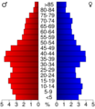
Age pyramid for Clinton County in 2000

See also
 In Spanish: Condado de Clinton (Illinois) para niños
