
Madison County, Illinois facts for kids
Quick facts for kids
Madison County
|
|
|---|---|

Madison County Courthouse in Edwardsville
|
|

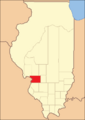
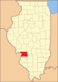
Location within the U.S. state of Illinois
|
|
 Illinois's location within the U.S. |
|
| Country | |
| State | |
| Founded | September 14, 1812 |
| Named for | James Madison |
| Seat | Edwardsville |
| Largest city | Granite City |
| Area | |
| • Total | 741 sq mi (1,920 km2) |
| • Land | 716 sq mi (1,850 km2) |
| • Water | 25 sq mi (60 km2) 3.4% |
| Population
(2020)
|
|
| • Total | 264,776 |
| • Estimate
(2023)
|
262,752 |
| • Density | 357.32/sq mi (137.96/km2) |
| Time zone | UTC−6 (Central) |
| • Summer (DST) | UTC−5 (CDT) |
| Congressional districts | 13th, 15th |
Madison County is a county in the U.S. state of Illinois. It is located in the Metro East area of southern Illinois. In 2020, about 264,776 people lived here. This makes it the eighth-most populated county in Illinois. It is also the most populated county in the southern part of the state. The main city, or county seat, is Edwardsville. The biggest city is Granite City.
Madison County is part of the larger Greater St. Louis area. A very old city called Cahokia Mounds was once located near Collinsville. This site is now a World Heritage Site. Southern Illinois University Edwardsville is in Edwardsville. The city of Alton is known for its history related to ending slavery and the American Civil War. It also has the Southern Illinois University School of Dental Medicine. In Godfrey, you can find Lewis and Clark Community College.
Contents
History of Madison County
Madison County was created on September 14, 1812. It was formed from parts of Randolph and St. Clair counties. The county was named after President James Madison. When it was first formed, Madison County was very large. It included all of what is now northern Illinois. It also covered all of Wisconsin, part of Minnesota, and Michigan's Upper Peninsula.
In the late 1800s, Madison County became a place with many factories. In the 1900s, it was known for making things like steel and oil. Many people worked in these industries. The county and nearby areas were strong supporters of the Democratic Party.
Over time, many factory jobs were lost. This caused the population to decrease. Today, the county is part of the "Metro East" area, which is east of St. Louis. St. Clair County is also part of this area.
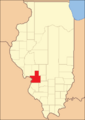
-
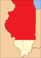
Madison County between its creation in 1812 and 1815. It stretched north to Lake Superior.
-
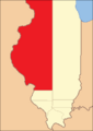
Madison County between 1815 and 1817.
-
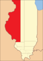
Madison County between 1817 and 1821.
-
Madison County between 1821 and 1825.
-
Between 1825 and 1829, Madison included a northern part that later became part of Macoupin County.
-
In 1829, Madison went back to its 1821 borders.
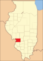
-
In 1843, a small piece of land was given to Bond County. This made Madison County its current size.


Geography and Climate
Madison County covers about 741 square miles (1,919 square kilometers). About 716 square miles (1,854 square kilometers) is land. The rest, about 25 square miles (65 square kilometers), is water. The county is located along the Mississippi River. Another important body of water is Horseshoe Lake.
Weather in Madison County
| Weather chart for Edwardsville, Illinois | |||||||||||||||||||||||||||||||||||||||||||||||
|---|---|---|---|---|---|---|---|---|---|---|---|---|---|---|---|---|---|---|---|---|---|---|---|---|---|---|---|---|---|---|---|---|---|---|---|---|---|---|---|---|---|---|---|---|---|---|---|
| J | F | M | A | M | J | J | A | S | O | N | D | ||||||||||||||||||||||||||||||||||||
|
2
36
19
|
2.3
42
24
|
3.5
52
34
|
4.2
64
45
|
4.2
75
55
|
3.2
84
64
|
3.5
90
70
|
3.2
86
66
|
3.1
79
58
|
2.7
68
46
|
3.8
53
35
|
2.9
41
25
|
||||||||||||||||||||||||||||||||||||
| temperatures in °F precipitation totals in inches source: The Weather Channel |
|||||||||||||||||||||||||||||||||||||||||||||||
|
Metric conversion
|
|||||||||||||||||||||||||||||||||||||||||||||||
In Edwardsville, the county seat, temperatures change throughout the year. In January, the average low is 19°F (-7°C). In July, the average high is 90°F (32°C). The coldest temperature ever recorded was -27°F (-33°C) in January 1977. The hottest was 114°F (46°C) in July 2012. The amount of rain or snow also changes. May usually gets the most, about 4.24 inches (10.8 cm). January gets the least, about 1.99 inches (5.1 cm).
Neighboring Counties and Cities
Madison County is next to several other counties and cities:
- Bond County - east
- Clinton County - southeast
- Jersey County - northwest
- Macoupin County - north
- Montgomery County - northeast
- St. Charles County, Missouri - northwest
- St. Clair County - south
- St. Louis, Missouri - west
- St. Louis County, Missouri - west
Parks and Natural Areas
You can find several parks and natural reserves in Madison County:
- Chouteau Island
- Gabaret Island
- Horseshoe Lake State Park
- Mosenthein Island
Transportation in Madison County
Madison County Transit helps people get around. It has 25 bus routes and 85 miles (137 km) of bike trails. For longer trips, Amtrak trains stop at Alton station. These trains, called the Lincoln Service, travel between Chicago and St. Louis.
Main Roads
Many important highways run through Madison County:
 I-55
I-55 I-70
I-70 I-255
I-255 I-270
I-270 US 40
US 40 US 67
US 67 IL 3
IL 3 IL 4
IL 4 IL 100
 IL 162
 IL 140
 IL 160
 IL 143
 IL 157
 IL 159
 IL 111
 IL 203
 IL 255
 IL 267

People of Madison County
| Historical population | |||
|---|---|---|---|
| Census | Pop. | %± | |
| 1820 | 13,550 | — | |
| 1830 | 6,221 | −54.1% | |
| 1840 | 14,433 | 132.0% | |
| 1850 | 20,441 | 41.6% | |
| 1860 | 31,251 | 52.9% | |
| 1870 | 44,131 | 41.2% | |
| 1880 | 50,126 | 13.6% | |
| 1890 | 51,535 | 2.8% | |
| 1900 | 64,694 | 25.5% | |
| 1910 | 89,847 | 38.9% | |
| 1920 | 106,895 | 19.0% | |
| 1930 | 143,830 | 34.6% | |
| 1940 | 149,349 | 3.8% | |
| 1950 | 182,307 | 22.1% | |
| 1960 | 224,689 | 23.2% | |
| 1970 | 250,934 | 11.7% | |
| 1980 | 247,691 | −1.3% | |
| 1990 | 249,238 | 0.6% | |
| 2000 | 258,941 | 3.9% | |
| 2010 | 269,282 | 4.0% | |
| 2020 | 265,859 | −1.3% | |
| 2023 (est.) | 262,752 | −2.4% | |
| U.S. Decennial Census 1790-1960 1900-1990 1990-2000 2010-2019 |
|||
The 2020 census showed that about 81.4% of the people in Madison County were white. About 9.4% were Black or African American. About 1.0% were Asian, and 0.3% were American Indian. About 6.3% were of two or more races, and 1.5% were of another race. People of Hispanic or Latino background made up 4.1% of the population.
In 2010, there were 269,282 people living in the county. There were 108,094 households. About 31.4% of households had children under 18. About 49.3% were married couples. The average household had 2.46 people. The average family had 2.98 people. The average age of people in the county was 38.6 years old.
The average income for a household in the county was $51,941. For families, it was $64,630. About 12.9% of the population lived below the poverty line. This included 19.3% of those under 18.
Communities in Madison County

Madison County has several cities, villages, and other communities.
Cities
Villages
Census Designated Places
These are areas that are like towns but are not officially incorporated as cities or villages.
Other Communities
These are smaller, unincorporated areas or historic places.
- Binney
- Cottage Hills
- Donkville
- Dorsey
- Fosterburg
- Gard
- Goshen Settlement
- Kaufman
- Kuhn Station
- LeClaire
- Lincoln Place
- Lumaghi Heights
- Meadowbrook
- Midway
- Newport
- Poag
- St. Morgan
- State Park Place
- Upper Alton
- Wanda
Townships
Madison County is divided into twenty-four townships. These are smaller government areas within the county.
- Alhambra
- Alton
- Chouteau
- Collinsville
- Edwardsville
- Fort Russell
- Foster
- Godfrey
- Granite City
- Hamel
- Helvetia
- Jarvis
- Leef
- Marine
- Moro
- Nameoki
- New Douglas
- Olive
- Omphghent
- Pin Oak
- Saline
- St. Jacob
- Venice
- Wood River
Islands
Historic Settlements
Population Ranking of Communities
The table below shows the population of the largest communities in Madison County, based on the 2020 census.
† county seat
| Rank | Place | Municipal type | Population (2020 Census) |
|---|---|---|---|
| 1 | Granite City | City | 27,549 |
| 2 | † Edwardsville | City | 26,808 |
| 3 | Alton | City | 25,676 |
| 4 | Collinsville (partially in St. Clair County) | City | 24,366 |
| 5 | Godfrey | Village | 17,825 |
| 6 | Glen Carbon | Village | 13,842 |
| 7 | Troy | City | 10,960 |
| 8 | Wood River | Village | 10,464 |
| 9 | Highland | City | 9,991 |
| 10 | Bethalto | Village | 9,310 |
| 11 | Maryville | Village | 8,221 |
| 12 | Pontoon Beach | Village | 5,876 |
| 13 | East Alton | Village | 5,786 |
| 14 | Rosewood Heights | CDP | 3,971 |
| 15 | Madison (partially in St. Clair County) | City | 3,171 |
| 16 | Holiday Shores | CDP | 2,840 |
| 17 | Fairmont City (partially in St. Clair County) | City | 2,265 |
| 18 | South Roxana | Village | 1,891 |
| 19 | Venice | City | 1,498 |
| 20 | Roxana | Village | 1,454 |
| 21 | St. Jacob | Village | 1,358 |
| 22 | Mitchell | CDP | 1,217 |
| 23 | Hartford | Village | 1,185 |
| 24 | Worden | Village | 1,096 |
| 25 | Hamel | Village | 929 |
| 26 | Marine | Village | 912 |
| 27 | Livingston | Village | 763 |
| 28 | Alhambra | Village | 622 |
| 29 | Pierron | Village | 459 |
| 30 | Moro | CDP | 397 |
| 31 | New Douglas | Village | 350 |
| 32 | Grantfork | Village | 341 |
| 33 | Williamson | Village | 183 |
Education in Madison County
Madison County has several school districts that serve its communities:
- Alton Community Unit School District 11
- Bethalto Community Unit School District 8
- Collinsville Community Unit School District 10
- East Alton School District 13
- East Alton-Wood River Community High School District 14
- Edwardsville Community Unit School District 7
- Granite City Community Unit School District 9
- Highland Community Unit School District 5
- Madison Community Unit School District 12
- Roxana Community Unit School District 1
- Triad Community Unit School District 2
- Venice Community Unit School District 3
- Wood River-Hartford Elementary School District 15
See also
 In Spanish: Condado de Madison (Illinois) para niños
