Fairmont City, Illinois facts for kids
Quick facts for kids
Fairmont City, Illinois
|
|
|---|---|

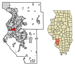
Location in St. Clair and Madison counties, Illinois
|
|
| Country | |
| State | |
| Counties | St. Clair; Madison |
| Townships | Canteen; Stites; Nameoki |
| Area | |
| • Total | 6.55 sq mi (16.96 km2) |
| • Land | 6.21 sq mi (16.07 km2) |
| • Water | 0.34 sq mi (0.89 km2) |
| Elevation | 420 ft (130 m) |
| Population
(2020)
|
|
| • Total | 2,265 |
| • Density | 365.03/sq mi (140.95/km2) |
| Time zone | UTC-6 (CST) |
| • Summer (DST) | UTC-5 (CDT) |
| ZIP Codes |
62201
|
| Area code(s) | 618 |
| FIPS code | 17-24933 |
| GNIS feature ID | 2398855 |
| Wikimedia Commons | Fairmont City, Illinois |
Fairmont City is a small village located in Illinois, mainly in St. Clair County with a small part in Madison County. In 2020, about 2,265 people lived there. The village has seen a big change in its population. During the 1990s, the number of people of Hispanic descent living in Fairmont City doubled. By 2020, more than 79% of the people in the village were of Hispanic descent.
Contents
Fairmont City's Location and Land
Fairmont City is in the northwestern part of St. Clair County. It's located at 38°39′4″N 90°5′59″W. The village is surrounded by other towns. To the northwest is Brooklyn, and to the north is Madison. Pontoon Beach is to the northeast, and Collinsville is to the east. Caseyville is to the southeast, Washington Park to the south, and East St. Louis to the southwest.
The village also stretches west for about 3 miles (4.8 km). This part of Fairmont City touches the Mississippi River. From there, you can see St. Louis right across the river.
Fairmont City covers a total area of about 6.55 square miles (16.96 km²). Most of this area, about 6.21 square miles (16.07 km²), is land. The rest, about 0.34 square miles (0.89 km²), is water.
History and Special Sites
Fairmont City is built on top of parts of the Cahokia Mounds. This is a very important historical site. It is recognized as a World Heritage Site by UNESCO. One of these ancient mounds, called Sam Chucalo Mound, is in the western part of the village. Other mounds are in the eastern part, within the Cahokia Mounds State Historic Site. These mounds are remnants of a large ancient city.
In 2016, an area in Fairmont City called the Old American Zinc site was added to a special list for cleanup. This happened after the Illinois EPA found high levels of lead, arsenic, cadmium, and zinc in the soil. These are harmful substances.
Fairmont City is about 5 miles (8 km) east of the famous Gateway Arch in St. Louis. If you are in Fairmont City, you can often see beautiful sunsets with the Arch and the St. Louis skyline in the background. Collinsville Road runs through the village. This road used to have many old, unique roadside advertisements.
In 1997, a nearby town called National City was officially closed down. Fairmont City then took over, or annexed, that area.
Fairmont City's People
In 2000, there were 2,436 people living in Fairmont City. There were 871 households, and 580 of these were families. The village had about 1,013 people per square mile (390.5 per km²).
About 29.9% of households had children under 18 living with them. About 45.9% of households were married couples. About 11.7% were single mothers with no husband present. The average household had 2.80 people, and the average family had 3.45 people.
The population was quite mixed in age. About 26.7% of the people were under 18 years old. About 11.7% were between 18 and 24. The largest group, 28.7%, was between 25 and 44. About 14.2% of the population was 65 years or older. The average age in the village was 32 years.
Village Services
Fairmont City has a library that has received international recognition. In 2017, the Fairmont City Library won the International Grand Prize First Place for Library-community interaction. It even beat out larger libraries from Kansas City and North Carolina!
Notable People
- Johnny Wyrostek was a baseball player. He also served as the Mayor of Fairmont City from 1967 until he passed away in 1986.
See also
 In Spanish: Fairmont City (Illinois) para niños
 | Calvin Brent |
 | Walter T. Bailey |
 | Martha Cassell Thompson |
 | Alberta Jeannette Cassell |


