
Cahokia facts for kids
Quick facts for kids Cahokia Mounds State Historic Site |
|
|---|---|

Monks Mound is the largest earthen structure at Cahokia. You can see people at the bottom and on top, which shows how big it is. About 80 of these mounds still exist at the site today.
|
|

Cahokia Mounds State Historic Site
Location in the United States
|
|
| Location | St. Clair County, Illinois, U.S. |
| Nearest city | Collinsville, Illinois |
| Area | 2,200 acres (8.9 km2) |
| Governing body | Illinois Historic Preservation Division |
| Official name: Cahokia Mounds State Historic Site | |
| Type: | Cultural |
| Criteria: | iii, iv |
| Designated: | 1982 (6th session) |
| Reference #: | 198 |
| Region: | Europe and North America |
| Official name: Cahokia Mounds | |
| Designated: | October 15, 1966 |
| Reference #: | 66000899 |
| Official name: Cahokia Mounds | |
| Designated: | July 19, 1964 |
Cahokia Mounds was a huge city built by Native Americans a long time ago, from about 1050 to 1350 CE. It is located in southern Illinois, right across the Mississippi River from the modern city of St. Louis.
This ancient city was the largest and most important center of the Mississippian culture. At its peak around 1100 CE, Cahokia was home to as many as 20,000 people. The city was massive, covering about six square miles. It had around 120 large, man-made hills called mounds. Today, about 80 of these mounds still remain.
Cahokia was the biggest and most complex city north of the great ancient cities in Mexico. The people who lived there did not leave behind any written records. We don't even know the city's original name. The name "Cahokia" comes from a different tribe that lived in the area much later.
Today, Cahokia Mounds is a National Historic Landmark and a UNESCO World Heritage Site. This means it is recognized as one of the most important historical places in the world. It is a popular place to visit and learn about the incredible achievements of its ancient builders.
Contents
The Story of Cahokia

A City is Born
People lived in the area around Cahokia for thousands of years. But around 600 CE, they began to form larger villages. The first mounds were built in the 9th century. The people were farmers who grew crops like corn (maize).
Then, around the year 1050 CE, something amazing happened. The city experienced a "Big Bang" of growth. The population grew very quickly, and people built dozens of mounds and huge public squares called plazas. It became a major center for religion, trade, and culture.
Life at its Peak
At its peak, Cahokia was a bustling city. It was located near where the Mississippi, Missouri, and Illinois rivers meet. This was a perfect spot for trade. People in Cahokia traded with communities from as far away as the Great Lakes in the north and the Gulf Coast in the south. They traded for special items like copper, seashells, and shark teeth.
The city was carefully planned. The mounds and plazas were arranged in a pattern that had special meaning. Thousands of workers built the giant mounds by hand, carrying basket after basket of earth. This huge effort shows that the city's leaders were very organized and powerful.
To protect the city's center, the people of Cahokia built a tall wooden wall, called a palisade. This wall was two miles long and had watchtowers. It was rebuilt several times.
Why Was Cahokia Abandoned?

After 1200 CE, the city began to shrink. People started to leave, and by 1350, Cahokia was almost completely empty. No one knows for sure why everyone left, but historians and archaeologists have a few ideas:
- Environmental problems: The large population may have used up all the nearby resources, like trees. Also, evidence shows that major floods may have damaged homes and farms.
- Climate change: A change in the climate could have led to droughts, making it harder to grow food for so many people.
- Social and political issues: There may have been conflicts or disagreements among the people living in the city, or with neighboring groups.
By 1400 CE, the great city was abandoned. For centuries, the land was mostly empty, until new Native American tribes and later, European settlers, arrived in the area.
Amazing Structures of Cahokia
The people of Cahokia were expert engineers and builders. They created many incredible structures that you can still see today.
Monks Mound

Monks Mound is the largest structure in Cahokia and the largest man-made earthen mound in North America. It is as tall as a 10-story building and covers over 14 acres. It was built in several stages over hundreds of years.
On top of this huge mound stood a very large building, about 5,000 square feet. This was likely a temple or the home of the city's most important leader. From here, the leader could look out over the entire city.
The Grand Plaza
South of Monks Mound is a huge, flat area called the Grand Plaza. It covers about 50 acres. The builders of Cahokia leveled this entire area by hand, which was a massive engineering project.
The plaza was used for large ceremonies, festivals, and public gatherings. It was also where people played a game called chunkey. In chunkey, players would roll a stone disc and throw spears to see who could get closest to where the stone stopped.
Mound 72

Mound 72 is a smaller, ridge-shaped mound that was used for burials. Archaeologists have learned a lot about Cahokia's culture from this mound.
One of the most famous discoveries is the "Birdman Burial." An important leader was buried on a bed of more than 20,000 seashell beads. The beads were arranged in the shape of a falcon, a bird that was a powerful symbol in Mississippian culture.
About 270 other people were also buried in Mound 72 over time. Many of these burials appear to have been part of large, important ceremonies. These discoveries show that religion and ritual were a central part of life in Cahokia.
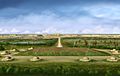
The Cahokia Woodhenge

To the west of Monks Mound, archaeologists discovered a series of large circles made of wooden posts. They named this a "Woodhenge," after Stonehenge in England.
The Woodhenge acted as a calendar. The posts were carefully placed to line up with the rising sun on important days of the year, like the first day of winter and summer (the solstices) and the first day of spring and fall (the equinoxes). This helped the people of Cahokia track the seasons for farming and for religious ceremonies. A reconstruction of one of the circles stands at the site today.
Cahokia's Legacy Today

Even though the city was abandoned centuries ago, Cahokia is still a very important place.
A Sacred Place
Many modern Native American groups, including the Osage Nation, consider Cahokia to be a sacred site and an important part of their heritage. They continue to visit the mounds to hold ceremonies and honor their ancestors. The site inspires many Native American artists and writers today.
A World Heritage Site
Cahokia Mounds is protected as a State Historic Site and is also a UNESCO World Heritage Site. This special status recognizes it as one of the most important archaeological sites in the world.
There is a museum and interpretive center at the site where visitors can learn about the history of the city and the people who built it. The center helps tell the story of this amazing ancient metropolis to over a million visitors each year.
-
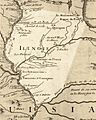
A French map from 1718 showing the location of the Caouquias (Cahokia) people.
-
The Rattlesnake Causeway was a ceremonial path that connected Monks Mound to another mound to the south.
-
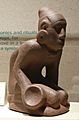
This small statue shows a person playing chunkey. It was found far from Cahokia, showing how wide their trade network was.
-
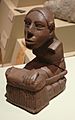
A clay statue of a person that was found at the Cahokia site.
-
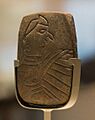
A stone tablet showing a "Birdman," a common symbol in Mississippian art. It was found on the side of Monks Mound.


See also
 In Spanish: Cahokia para niños
- American Bottom
- Hopewell tradition
- Mississippian culture
- List of Mississippian sites
- Mississippian Ideological Interaction Sphere
- Mississippian stone statuary
- Poverty Point – A UNESCO-designated mound complex in Louisiana.
- Hopewell Ceremonial Earthworks – A UNESCO-designated mound complex in Ohio.
- List of World Heritage Sites in the United States
