Macoupin County, Illinois facts for kids
Quick facts for kids
Macoupin County
|
|
|---|---|

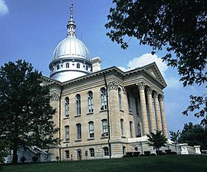
Macoupin County Courthouse in Carlinville
|
|

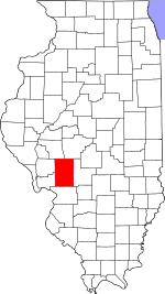
Location within the U.S. state of Illinois
|
|
 Illinois's location within the U.S. |
|
| Country | |
| State | |
| Founded | 1829 |
| Named for | Macoupin Creek |
| Seat | Carlinville |
| Largest city | Carlinville |
| Area | |
| • Total | 868 sq mi (2,250 km2) |
| • Land | 863 sq mi (2,240 km2) |
| • Water | 4.7 sq mi (12 km2) 0.5% |
| Population
(2020)
|
|
| • Total | 44,967 |
| • Density | 51.805/sq mi (20.002/km2) |
| Time zone | UTC−6 (Central) |
| • Summer (DST) | UTC−5 (CDT) |
| Congressional district | 13th |
Macoupin County is a county in the state of Illinois, USA. In 2020, about 44,967 people lived there. The main town and county seat is Carlinville.
The county's main business is agriculture. Farmers grow crops like corn, soybeans, and some wheat.
Contents
History of Macoupin County
Long ago, Illinoisan Indians lived in this area. They were here before the first European explorers arrived. The name Macoupin comes from a Native American word. It means "American lotus," which is a type of water lily.
French explorers first came to this region in the 1600s. They traveled south along the big rivers. Later, many European settlers moved here from the southwest. They came from areas near the Mississippi River.
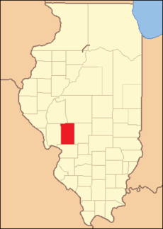
Macoupin County was officially created on January 17, 1829. It was formed from parts of Greene and Madison Counties. The county was named after Macoupin Creek. This creek flows near Carlinville and goes towards the Illinois River. At first, people mainly farmed to feed themselves and their families.
Growth and Railroads
In the mid-1800s, Illinois grew very quickly. A big change was the building of railroads. Macoupin County became an important link. It was on the path between St. Louis and the growing city of Chicago. The county is also halfway between St. Louis and Springfield, the state capital.
Farming was still the main business. But now, it was easier to sell crops in bigger markets. Towns were small and spread out. New towns often started along the railroad lines. These lines helped transport goods and people.
Coal Mining and Changes
Later, coal mining became important in Macoupin County. Coal was found under the whole area. Mines were built near railroad tracks and towns. This made it easy to move the coal. By the 1900s, many towns had mines. Many miners came from different parts of Europe.
Farming and coal mining were the county's main jobs for a long time. The county's success often depended on these industries. Macoupin County was also a place where workers often fought for their rights. There were big disagreements between mine owners and miners. This led to strong union activity.
Over time, farming changed. Large companies started to take over. Small family farms became less common. Coal mining also slowed down and has almost stopped completely. Many old mining buildings are now gone.
Towns and Commuting
Most towns in Macoupin County have a special layout. Some have a central town square with a park and shops around it. Carlinville is like this, with the main county building in the center. Other towns have a single main street with businesses on both sides.
Today, good roads make it easy to travel. Some towns in the north of the county have become "bedroom communities." This means people live there but travel to Springfield for work and shopping. The same thing happens in the southern part of the county. In 2005, the U.S. Census Bureau added Macoupin County to the St. Louis Metropolitan Statistical Area. This was because more people were traveling to St. Louis for jobs.
Where is Macoupin County?
The U.S. Census Bureau says the county covers about 868 square miles. About 863 square miles are land, and 4.7 square miles are water.
Weather in Macoupin County
| Weather chart for Carlinville, Illinois | |||||||||||||||||||||||||||||||||||||||||||||||
|---|---|---|---|---|---|---|---|---|---|---|---|---|---|---|---|---|---|---|---|---|---|---|---|---|---|---|---|---|---|---|---|---|---|---|---|---|---|---|---|---|---|---|---|---|---|---|---|
| J | F | M | A | M | J | J | A | S | O | N | D | ||||||||||||||||||||||||||||||||||||
|
2
35
17
|
2
41
22
|
3.5
53
32
|
4
65
43
|
4.3
75
53
|
3.9
84
62
|
3.7
87
67
|
3.3
86
64
|
2.9
79
56
|
2.7
68
44
|
3.6
52
33
|
2.9
40
23
|
||||||||||||||||||||||||||||||||||||
| temperatures in °F precipitation totals in inches source: The Weather Channel |
|||||||||||||||||||||||||||||||||||||||||||||||
|
Metric conversion
|
|||||||||||||||||||||||||||||||||||||||||||||||
In Carlinville, the county seat, temperatures change a lot. In January, the average low is about 17°F. In July, the average high is about 87°F. The coldest temperature ever recorded was -23°F in February 1905. The hottest was 113°F in July 1954.
The amount of rain and snow also varies. February usually has the least, about 1.95 inches. May usually has the most, about 4.25 inches.
Main Roads
 Interstate 55
 Illinois Route 4
 Illinois Route 16
 Illinois Route 138
 Illinois Route 108
 Illinois Route 111
 Illinois Route 159
 Illinois Route 267
Neighboring Counties
- Sangamon County – to the northeast
- Montgomery County – to the east
- Madison County – to the south
- Greene County – to the west
- Jersey County – to the west
- Morgan County – to the northwest
People of Macoupin County
| Historical population | |||
|---|---|---|---|
| Census | Pop. | %± | |
| 1830 | 1,990 | — | |
| 1840 | 7,826 | 293.3% | |
| 1850 | 12,355 | 57.9% | |
| 1860 | 24,602 | 99.1% | |
| 1870 | 32,726 | 33.0% | |
| 1880 | 37,692 | 15.2% | |
| 1890 | 40,352 | 7.1% | |
| 1900 | 42,256 | 4.7% | |
| 1910 | 50,685 | 19.9% | |
| 1920 | 57,274 | 13.0% | |
| 1930 | 48,703 | −15.0% | |
| 1940 | 46,304 | −4.9% | |
| 1950 | 44,210 | −4.5% | |
| 1960 | 43,524 | −1.6% | |
| 1970 | 44,557 | 2.4% | |
| 1980 | 49,384 | 10.8% | |
| 1990 | 47,679 | −3.5% | |
| 2000 | 49,019 | 2.8% | |
| 2010 | 47,765 | −2.6% | |
| 2020 | 44,967 | −5.9% | |
| 2023 (est.) | 44,018 | −7.8% | |
| U.S. Decennial Census 1790-1960 1900-1990 1990-2000 2010 |
|||
In 2010, there were 47,765 people living in Macoupin County. There were about 19,381 households. The average age of people in the county was 41.7 years old.
The average income for a household was about $47,178. For families, it was about $59,700.
Towns and Villages
Cities
- Benld
- Bunker Hill
- Carlinville (county seat)
- Gillespie
- Girard
- Mount Olive
- Staunton
- Virden
Towns
Villages
Other Communities
Townships
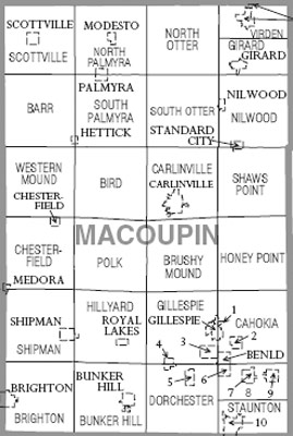
Macoupin County is divided into twenty-six smaller areas called townships.
- Barr
- Bird
- Brighton
- Brushy Mound
- Bunker Hill
- Cahokia
- Carlinville
- Chesterfield
- Dorchester
- Gillespie
- Girard
- Hillyard
- Honey Point
- Mount Olive
- Nilwood
- North Otter
- North Palmyra
- Polk
- Scottville
- Shaws Point
- Shipman
- South Otter
- South Palmyra
- Staunton
- Virden
- Western Mound
Schools in Macoupin County
- Bunker Hill Community Unit School District 8
- Carlinville Community Unit School District 1
- Gillespie Community Unit School District 7
- Mount Olive Community Unit School District 5
- North Mac Community Unit School District 34
- Northwestern Community Unit School District 2
- Southwestern Community Unit School District 9
- Staunton Community Unit School District 6
See also
 In Spanish: Condado de Macoupin para niños
 | Jessica Watkins |
 | Robert Henry Lawrence Jr. |
 | Mae Jemison |
 | Sian Proctor |
 | Guion Bluford |


