Scottville, Illinois facts for kids
Quick facts for kids
Scottville, Illinois
|
|
|---|---|

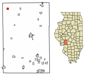
Location in Macoupin County, Illinois
|
|
| Country | United States |
| State | Illinois |
| County | Macoupin |
| Township | Scottville |
| Area | |
| • Total | 1.00 sq mi (2.58 km2) |
| • Land | 1.00 sq mi (2.58 km2) |
| • Water | 0.00 sq mi (0.00 km2) |
| Elevation | 651 ft (198 m) |
| Population
(2020)
|
|
| • Total | 93 |
| • Density | 93.28/sq mi (36.03/km2) |
| Time zone | UTC-6 (CST) |
| • Summer (DST) | UTC-5 (CDT) |
| ZIP codes |
62683 (Scottville)
62674 (Palmyra) |
| Area code(s) | 217 |
| FIPS code | 17-68406 |
Scottville is a small village in Illinois, United States. It is located in Macoupin County. In 2020, only 93 people lived there.
Contents
History of Scottville
It is believed that a man named Benjamin Stephenson planned the town in 1835. However, Scottville did not officially become a village until 1885. A post office opened in the village that same year. Today, Scottville no longer has its own post office.
Scottville High School and Education
Scottville had its own high school from the late 1800s until 1948. In 1948, Scottville joined with three other nearby towns. These towns were Palmyra, Modesto, and Hettick. They formed the Northwestern School District to combine their schools. Now, students from Scottville go to Northwestern Jr-Sr High School in Palmyra.
Population Changes Over Time
Scottville's population was highest in 1900, with 364 people. Since then, the number of people living in the village has gone down. By 2020, only 93 people lived there.
Geography of Scottville
Scottville is in the northwestern part of Macoupin County. Its exact location is 39°28′44″N 90°6′13″W / 39.47889°N 90.10361°W. It is about 8 miles (13 km) northwest of Palmyra. It is also about 24 miles (39 km) northwest of Carlinville, which is the main town of the county.
The U.S. Census Bureau says that Scottville covers about 1 square mile (2.58 square kilometers) of land. There is no water area within the village. Small streams, like the headwaters of Rock Branch, flow through Scottville. These streams eventually lead to Apple Creek, which flows into the Illinois River.
People of Scottville
| Historical population | |||
|---|---|---|---|
| Census | Pop. | %± | |
| 1880 | 284 | — | |
| 1890 | 363 | 27.8% | |
| 1900 | 364 | 0.3% | |
| 1910 | 301 | −17.3% | |
| 1920 | 285 | −5.3% | |
| 1930 | 198 | −30.5% | |
| 1940 | 277 | 39.9% | |
| 1950 | 200 | −27.8% | |
| 1960 | 186 | −7.0% | |
| 1970 | 196 | 5.4% | |
| 1980 | 214 | 9.2% | |
| 1990 | 165 | −22.9% | |
| 2000 | 140 | −15.2% | |
| 2010 | 116 | −17.1% | |
| 2020 | 93 | −19.8% | |
| U.S. Decennial Census | |||
In the year 2000, there were 140 people living in Scottville. These people lived in 57 homes, and 42 of these were families. The village had about 140 people for every square mile. There were 63 housing units in total. All the people living in the village were White.
Households and Families
Out of the 57 homes, almost 30% had children under 18 living there. More than half of the homes (56.1%) were married couples. About 10% of homes had a female head of household with no husband. About 26% of homes were not families.
Almost a quarter of all homes (22.8%) had only one person living in them. About 10% of homes had someone aged 65 or older living alone. On average, there were 2.46 people in each home. For families, the average size was 2.88 people.
Age and Income
The people in Scottville were spread out by age. About 25.7% were under 18 years old. About 4.3% were between 18 and 24. About 26.4% were between 25 and 44. About 24.3% were between 45 and 64. And 19.3% were 65 years or older. The average age in the village was 41 years.
The average income for a home in Scottville was $31,875 in 2000. For families, the average income was $30,833. Men earned more on average ($35,625) than women ($22,083). The average income per person in the village was $14,362. About 14.3% of families and 17.5% of all people lived below the poverty line. This included 25.7% of those under 18 and 20.0% of those over 64.
See also
 In Spanish: Scottville (Illinois) para niños
 | Jackie Robinson |
 | Jack Johnson |
 | Althea Gibson |
 | Arthur Ashe |
 | Muhammad Ali |


