
Mount Olive, Illinois facts for kids
Quick facts for kids
Mount Olive, Illinois
|
|
|---|---|

Location in Macoupin County, Illinois
|
|

Mount Olive, Illinois
Location in the United States
|
|
| Country | United States |
| State | Illinois |
| County | Macoupin |
| Township | Mount Olive |
| Area | |
| • Total | 1.156 sq mi (2.99 km2) |
| • Land | 1.153 sq mi (2.99 km2) |
| • Water | 0.003 sq mi (0.008 km2) |
| Elevation | 682 ft (208 m) |
| Population
(2020)
|
|
| • Total | 2,015 |
| • Density | 1,747.61/sq mi (674.49/km2) |
| Time zone | UTC−6 (CST) |
| • Summer (DST) | UTC−5 (CDT) |
| ZIP code |
62069
|
| Area code(s) | 217 |
| FIPS code | 17-51024 |
| GNIS feature ID | 2395123 |
Mount Olive is a city located in Macoupin County, Illinois, in the United States. In 2020, about 2,015 people lived there. The city is part of the Metro East area, which is near the larger St. Louis metropolitan area.
Contents
Exploring Mount Olive's Location

Mount Olive is found in the southeastern part of Macoupin County. Illinois Route 138 starts here and goes west for about 5 miles to Benld. The famous old U.S. Route 66 used to pass through the city. Now, Interstate 55 is about 1 mile west of town. You can get to Mount Olive from Exit 44 on I-55.
Old Route 66 can take you about 8 miles northeast to Litchfield or about 6 miles southwest to Staunton. If you take I-55, you can travel about 50 miles north to Springfield or about 45 miles southwest to St. Louis.
The city covers an area of about 1.16 square miles. Most of this is land, with a very small part being water. Water from Mount Olive flows into two main creeks: Cahokia Creek, which goes to the Mississippi River, and Silver Creek, which flows into the Kaskaskia River.
Mount Olive's Population Over Time
| Historical population | |||
|---|---|---|---|
| Census | Pop. | %± | |
| 1880 | 709 | — | |
| 1890 | 1,986 | 180.1% | |
| 1900 | 2,935 | 47.8% | |
| 1910 | 3,501 | 19.3% | |
| 1920 | 3,503 | 0.1% | |
| 1930 | 3,079 | −12.1% | |
| 1940 | 2,559 | −16.9% | |
| 1950 | 2,401 | −6.2% | |
| 1960 | 2,295 | −4.4% | |
| 1970 | 2,288 | −0.3% | |
| 1980 | 2,357 | 3.0% | |
| 1990 | 2,126 | −9.8% | |
| 2000 | 2,150 | 1.1% | |
| 2010 | 2,099 | −2.4% | |
| 2020 | 2,015 | −4.0% | |
| U.S. Decennial Census | |||
The population of Mount Olive has changed over many years. In 1880, there were 709 people. The population grew a lot by 1910, reaching 3,501. Since then, it has slowly decreased. In 2020, the city had 2,015 residents.
According to the 2000 census, there were 2,150 people living in Mount Olive. Most residents were White, making up about 96.79% of the population. A small number of people were Native American or Asian. About 3% of the population identified as Hispanic or Latino.
In 2000, there were 906 households in the city. About 30.7% of these households had children under 18 living there. The average age of people in Mount Olive was 39 years old.
Famous People from Mount Olive
Many interesting people have connections to Mount Olive:
- Frank Biscan: A baseball pitcher who played for the St Louis Browns.
- Jess Dobernic: Another baseball pitcher, playing for teams like the Chicago Cubs and Chicago White Sox.
- Elmer Droste: An Illinois state senator and a lawyer.
- Adolph Germer: He was an important leader for the Socialist Party of America and a national union organizer.
- Mary Harris Jones (also known as "Mother Jones"): A very famous labor organizer who fought for workers' rights. She is buried in Mount Olive.
- Mike Kreevich: A baseball player for several teams, including the Chicago Cubs and Chicago White Sox.
Places to Visit in Mount Olive
Mount Olive has some important historical sites:
- Union Miners Cemetery: This cemetery is a special place where miners who died in the Battle of Virden are buried. It is also the final resting place of Mary Harris "Mother" Jones, the well-known labor organizer.
- Soulsby Service Station: This is the oldest gas station still operating on the historic U.S. Route 66 in Illinois. It's a cool spot to see a piece of American road trip history. You can find it easily by taking Exit 44 on Interstate 55 and following the signs.
Images for kids
-
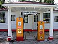
The historic Soulsby Service Station on old U.S. Route 66.
See also
 In Spanish: Mount Olive (Illinois) para niños
