Kaskaskia River facts for kids
Quick facts for kids Kaskaskia River |
|
|---|---|

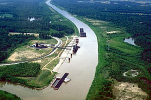
A coal loading facility on the Kaskaskia River near New Athens in St. Clair County, Illinois
|
|

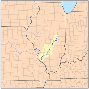
Kaskaskia River watershed map
|
|
| Country | United States |
| Physical characteristics | |
| Main source | Interstate 74 in Champaign County, Illinois west of Champaign, Illinois ~840 ft (260 m), (Yankee Ridge) 39°59′30″N 88°21′22″W / 39.991698°N 88.3561656°W |
| River mouth | Mississippi River 10 mi (16 km) northwest of Chester ~350 ft (110 m) 37°58′30″N 89°56′15″W / 37.974942°N 89.937372°W |
| Length | approximately 325 miles (523 km) |
| Basin features | |
| Basin size | approximately 5,746 sq mi (14,880 km2) |
| GNIS ID | 426395 |
The Kaskaskia River is a long river in Illinois, United States. It flows for about 325 miles (523 km) through the central and southern parts of the state. It is the second-biggest river system in Illinois. The Kaskaskia River eventually flows into the mighty Mississippi River.
The river flows through many farms and rolling hills. Its lower parts have thick hardwood forests. Some sections of the river have been made deeper and wider. This allows large barges to travel on it.
The name "Kaskaskia" comes from a group of Native Americans. These were the Illiniwek people. Early French explorers and settlers met them. Another old name for the river was "Okaw River." You can still see this name in places like Okawville. It is also used for a major river branch called the West Okaw River.
Contents
River's Journey: Source to Mouth
The Kaskaskia River starts in east-central Illinois. It begins as small farm ditches near Champaign. You can find its starting point just north of Interstate 74. A sign marks where the river begins its journey.
The river flows south through Champaign and Douglas counties. Then it turns southwest. It passes by towns like Vandalia. Finally, it joins the Mississippi River. This meeting point is about 10 miles (16 km) northwest of Chester. It is also about 40 miles (64 km) south of St. Louis, Missouri. The area drained by the Kaskaskia River is huge. It covers about 5,746 square miles (14,882 km²). This is about 10% of the entire state of Illinois.
Lakes Along the Kaskaskia
The Kaskaskia River has two large lakes built on it. These lakes help control floods and offer recreation.
- In Shelby County, the river is dammed to create Lake Shelbyville.
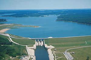
- Further downstream, in Clinton County, it forms Carlyle Lake. This lake is southwest of Vandalia.
How the River Changed Course
For most of the 1800s, the Kaskaskia River met the Mississippi River near Chester. But things changed. Many steamboats used the Mississippi River back then. To power these boats, people cut down many trees along the riverbanks. This made the banks weak. The Mississippi River became wider and shallower. This led to more serious floods.
After a very big flood in 1881, the Mississippi River changed its path. It moved east and started flowing through the last 10 miles (16 km) of the Kaskaskia River's channel. This moved the meeting point of the two rivers 10 miles (16 km) north.
Kaskaskia Island: A Piece of Illinois in Missouri
Because the Mississippi River changed course, a small part of Illinois was cut off. This area included the historic town of Kaskaskia. This town used to be the capital of Illinois. Now, it is on the west side of the Mississippi River. This means you can only reach Kaskaskia from the Missouri side. It's like a small island of Illinois surrounded by Missouri.
The Kaskaskia River State Fish & Wildlife Area is a protected natural area. It is located along the lower part of the river in southern Illinois. Near the river's mouth, in Randolph County, was the historic Fort Kaskaskia.
See also
 In Spanish: Río Kaskaskia para niños
 | Kyle Baker |
 | Joseph Yoakum |
 | Laura Wheeler Waring |
 | Henry Ossawa Tanner |


