
Shelby County, Illinois facts for kids
Quick facts for kids
Shelby County
|
|
|---|---|

Shelby County Courthouse
|
|

Location within the U.S. state of Illinois
|
|
 Illinois's location within the U.S. |
|
| Country | |
| State | |
| Founded | 1827 |
| Named for | Isaac Shelby |
| Seat | Shelbyville |
| Largest city | Shelbyville |
| Area | |
| • Total | 768 sq mi (1,990 km2) |
| • Land | 759 sq mi (1,970 km2) |
| • Water | 9.5 sq mi (25 km2) 1.2% |
| Population
(2020)
|
|
| • Total | 20,990 |
| • Estimate
(2023)
|
20,568 |
| • Density | 27.331/sq mi (10.552/km2) |
| Time zone | UTC−6 (Central) |
| • Summer (DST) | UTC−5 (CDT) |
| Congressional district | 15th |
Shelby County is a county located in the state of Illinois in the United States. In 2020, about 20,990 people lived here. The main town and government center is Shelbyville.
Contents
History of Shelby County
Shelby County was created in 1827. It was formed from a part of Fayette County. The county was named after Isaac Shelby. He was a governor of Kentucky. He also fought in the American Revolutionary War.
-
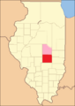
Shelby County when it was first created in 1827. It included a large area that wasn't fully organized yet.
-
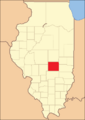
Shelby County between 1829 and 1839.
-
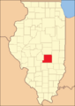
Shelby County between 1839 and 1843.
-
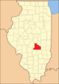
Shelby County in 1843, showing its current borders.


Geography of Shelby County
Shelby County covers a total area of about 768 square miles. Most of this area, about 759 square miles, is land. The remaining 9.5 square miles (or 1.2%) is water.
Climate and Weather in Shelby County
| Weather chart for Shelbyville, Illinois | |||||||||||||||||||||||||||||||||||||||||||||||
|---|---|---|---|---|---|---|---|---|---|---|---|---|---|---|---|---|---|---|---|---|---|---|---|---|---|---|---|---|---|---|---|---|---|---|---|---|---|---|---|---|---|---|---|---|---|---|---|
| J | F | M | A | M | J | J | A | S | O | N | D | ||||||||||||||||||||||||||||||||||||
|
2
34
19
|
1.9
41
24
|
3.3
52
33
|
3.7
65
43
|
4
75
53
|
4.1
83
62
|
4
87
66
|
3.3
85
63
|
3.1
80
56
|
3.1
68
45
|
3.9
52
35
|
3
39
24
|
||||||||||||||||||||||||||||||||||||
| temperatures in °F precipitation totals in inches source: The Weather Channel |
|||||||||||||||||||||||||||||||||||||||||||||||
|
Metric conversion
|
|||||||||||||||||||||||||||||||||||||||||||||||
In Shelbyville, the county seat, temperatures change a lot. In January, the average low is 19°F. In July, the average high is 87°F. The coldest temperature ever recorded was -26°F in January 1915. The hottest was 111°F in July 1936. Rain and snow also vary. February usually gets about 1.89 inches of precipitation. June gets the most, with about 4.05 inches.
Major Roads in Shelby County
Several important roads pass through Shelby County:
 Interstate 57
 U.S. Highway 45
 U.S. Highway 51
 Illinois Route 16
 Illinois Route 32
 Illinois Route 128
Counties Next to Shelby County
Shelby County shares its borders with several other counties:
- Macon County (north)
- Moultrie County (northeast)
- Coles County (east)
- Cumberland County (east)
- Effingham County (south)
- Fayette County (south)
- Montgomery County (southwest)
- Christian County (west)
Population of Shelby County
| Historical population | |||
|---|---|---|---|
| Census | Pop. | %± | |
| 1830 | 2,972 | — | |
| 1840 | 6,659 | 124.1% | |
| 1850 | 7,807 | 17.2% | |
| 1860 | 14,613 | 87.2% | |
| 1870 | 25,476 | 74.3% | |
| 1880 | 30,270 | 18.8% | |
| 1890 | 31,191 | 3.0% | |
| 1900 | 32,126 | 3.0% | |
| 1910 | 31,693 | −1.3% | |
| 1920 | 29,601 | −6.6% | |
| 1930 | 25,471 | −14.0% | |
| 1940 | 26,290 | 3.2% | |
| 1950 | 24,434 | −7.1% | |
| 1960 | 23,404 | −4.2% | |
| 1970 | 22,589 | −3.5% | |
| 1980 | 23,923 | 5.9% | |
| 1990 | 22,261 | −6.9% | |
| 2000 | 22,893 | 2.8% | |
| 2010 | 22,363 | −2.3% | |
| 2020 | 20,990 | −6.1% | |
| 2023 (est.) | 20,568 | −8.0% | |
| U.S. Decennial Census 1790-1960 1900-1990 1990-2000 2010-2013 |
|||
In 2010, there were 22,363 people living in Shelby County. The population density was about 29.5 people per square mile. Most people (98.6%) were white. About 0.8% of the population was of Hispanic or Latino origin. The average age of people in the county was 43.5 years old.
Special Places in Shelby County
The Census Bureau has named one special place in Shelby County:
Towns and Villages in Shelby County
Cities
- Shelbyville (This is the main town and where the county government is.)
- Windsor
Town
Villages
Other Small Communities
- Clarksburg
- Henton
- Lakewood
- Mode
See also
 In Spanish: Condado de Shelby (Illinois) para niños
