
Montgomery County, Illinois facts for kids
Quick facts for kids
Montgomery County
|
|
|---|---|

Montgomery County Courthouse, Hillsboro
|
|

Location within the U.S. state of Illinois
|
|
 Illinois's location within the U.S. |
|
| Country | |
| State | |
| Founded | 1821 |
| Named for | Richard Montgomery |
| Seat | Hillsboro |
| Largest city | Litchfield |
| Area | |
| • Total | 710 sq mi (1,800 km2) |
| • Land | 704 sq mi (1,820 km2) |
| • Water | 6.0 sq mi (16 km2) 0.8% |
| Population
(2020)
|
|
| • Total | 28,288 |
| • Density | 39.84/sq mi (15.38/km2) |
| Time zone | UTC−6 (Central) |
| • Summer (DST) | UTC−5 (CDT) |
| Congressional district | 15th |
Montgomery County is a special area in Illinois, a state in the United States. It's called a county. In 2020, about 28,288 people lived here. The main town, or county seat, where the county government is located, is Hillsboro.
Contents
History of Montgomery County
Montgomery County was created in 1821. It was formed from parts of two other counties: Bond County and Madison County.
The county was named after Richard Montgomery. He was a brave general during the American Revolutionary War. Sadly, he was killed in 1775 while trying to capture Quebec City, which is in Canada. An old book from 1882, called History of Montgomery County, says the county was named for him. However, some people aren't completely sure about where the name came from.
-
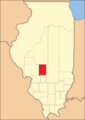
Montgomery County looked like this from when it was created until 1827.
-
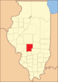
This map shows Montgomery County between 1827 and 1839.
-
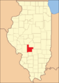
By 1839, Montgomery County had its current shape and size.


Geography and Nature
The U.S. Census Bureau says that Montgomery County covers a total area of about 710 square miles. Most of this area, about 704 square miles, is land. The rest, about 6.0 square miles, is water. This means about 0.8% of the county is covered by water.
Weather and Climate
| Weather chart for Hillsboro, Illinois | |||||||||||||||||||||||||||||||||||||||||||||||
|---|---|---|---|---|---|---|---|---|---|---|---|---|---|---|---|---|---|---|---|---|---|---|---|---|---|---|---|---|---|---|---|---|---|---|---|---|---|---|---|---|---|---|---|---|---|---|---|
| J | F | M | A | M | J | J | A | S | O | N | D | ||||||||||||||||||||||||||||||||||||
|
2.2
37
21
|
2
44
26
|
3.6
56
35
|
4.2
68
45
|
4.3
78
55
|
4.1
87
64
|
3.5
91
68
|
3.5
89
66
|
3.2
82
58
|
2.9
71
47
|
3.8
55
37
|
3
42
26
|
||||||||||||||||||||||||||||||||||||
| temperatures in °F precipitation totals in inches source: The Weather Channel |
|||||||||||||||||||||||||||||||||||||||||||||||
|
Metric conversion
|
|||||||||||||||||||||||||||||||||||||||||||||||
The weather in Hillsboro, the county seat, changes a lot throughout the year. In January, the average low temperature is about 21 degrees Fahrenheit. In July, the average high temperature can reach 91 degrees Fahrenheit.
However, temperatures can be extreme! The coldest temperature ever recorded was -22 degrees Fahrenheit in February 1905. The hottest was 114 degrees Fahrenheit in July 1954.
The amount of rain and snow also varies. February usually has the least amount of precipitation, about 2.00 inches. May often gets the most, with about 4.31 inches.
Neighboring Counties
Montgomery County shares its borders with several other counties:
- Sangamon County to the north
- Christian County to the northeast
- Shelby County to the east
- Fayette County to the southeast
- Bond County to the south
- Madison County to the southwest
- Macoupin County to the west
Getting Around: Transportation
Main Roads
Several important highways pass through Montgomery County, making it easy to travel. These include:
 Interstate 55
 Illinois Route 16
 Illinois Route 48
 Illinois Route 108
 Illinois Route 127
 Illinois Route 185
Airports
If you need to fly, the Litchfield Municipal Airport is located in Montgomery County. It's just a short distance southwest of the main part of Litchfield, Illinois.
People and Population
| Historical population | |||
|---|---|---|---|
| Census | Pop. | %± | |
| 1830 | 2,953 | — | |
| 1840 | 4,490 | 52.0% | |
| 1850 | 6,277 | 39.8% | |
| 1860 | 13,979 | 122.7% | |
| 1870 | 25,314 | 81.1% | |
| 1880 | 28,078 | 10.9% | |
| 1890 | 30,003 | 6.9% | |
| 1900 | 30,836 | 2.8% | |
| 1910 | 35,311 | 14.5% | |
| 1920 | 41,403 | 17.3% | |
| 1930 | 35,278 | −14.8% | |
| 1940 | 34,499 | −2.2% | |
| 1950 | 32,460 | −5.9% | |
| 1960 | 31,244 | −3.7% | |
| 1970 | 30,260 | −3.1% | |
| 1980 | 31,686 | 4.7% | |
| 1990 | 30,728 | −3.0% | |
| 2000 | 30,652 | −0.2% | |
| 2010 | 30,104 | −1.8% | |
| 2020 | 28,288 | −6.0% | |
| 2023 (est.) | 27,663 | −8.1% | |
| U.S. Decennial Census 1790-1960 1900-1990 1990-2000 2010 |
|||
In 2010, there were 30,104 people living in Montgomery County. These people lived in 11,652 homes, and 7,806 of those were families. On average, there were about 43 people per square mile.
Most of the people in the county were white (95.1%). A smaller number were black or African American (3.2%), Asian (0.4%), or American Indian (0.2%). About 1.5% of the population was of Hispanic or Latino background. Many families in the county have German (27.8%), Irish (11.2%), or English (10.1%) roots.
About 29.8% of homes had children under 18 living there. More than half of the homes (51.7%) were married couples. The average age of people in the county was 41.9 years old.
The average income for a household in the county was about $40,864 per year. For families, the average income was higher, around $56,945 per year. About 14.0% of all people in the county lived below the poverty line, which means they had a very low income. This included 22.7% of kids under 18.
Towns and Villages
Montgomery County has several towns and villages where people live.
Cities
Villages
Unincorporated Communities
These are smaller communities that are not officially part of a city or village.
Townships
Counties in Illinois are divided into smaller areas called townships.
- Audubon Township
- Bois D'Arc Township
- Butler Grove Township
- East Fork Township
- Fillmore Township
- Grisham Township
- Harvel Township
- Hillsboro Township
- Irving Township
- Nokomis Township
- North Litchfield Township
- Pitman Township
- Raymond Township
- Rountree Township
- South Litchfield Township
- Walshville Township
- Witt Township
- Zanesville Township
Former Townships
- South Fillmore Township
Famous People from Montgomery County
Many interesting people have come from Montgomery County:
- Donald T. Barry, a nurse, businessman, and politician
- Avery Bourne, a member of the Illinois House of Representatives
- Buddy Cole, a jazz musician and composer
- Mortimer A. Cullen, a politician from New York
- Harry Forrester, a coach for basketball and baseball
- Otto Funk (1868–1934), a talented violinist
- John A. Graham, a member of the Illinois Senate
- Betsy Hannig, a member of the Illinois House of Representatives
- Mary Hartline, an actress
- Glen Hobbie, a baseball player
- Matt Hughes, a famous UFC fighter
- Calvin Hultman, a member of the Iowa House of Representatives
- Harold Osborn, a track and field athlete
- Ray Richmond, a baseball pitcher
- Red Ruffing, a baseball player
- Walter Short, a military officer
See also
 In Spanish: Condado de Montgomery (Illinois) para niños
