Raymond, Illinois facts for kids
Quick facts for kids
Raymond, Illinois
|
|
|---|---|

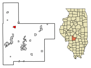
Location in Montgomery County, Illinois
|
|
| Country | United States |
| State | Illinois |
| County | Montgomery |
| Township | Raymond |
| Area | |
| • Total | 1.26 sq mi (3.26 km2) |
| • Land | 1.26 sq mi (3.26 km2) |
| • Water | 0.00 sq mi (0.00 km2) |
| Elevation | 646 ft (197 m) |
| Population
(2020)
|
|
| • Total | 949 |
| • Density | 754.97/sq mi (291.41/km2) |
| Time zone | UTC-6 (CST) |
| • Summer (DST) | UTC-5 (CDT) |
| ZIP code |
62560
|
| Area code(s) | 217 |
| FIPS code | 17-62965 |
| GNIS feature ID | 2399049 |
| Wikimedia Commons | Raymond, Illinois |
Raymond is a small village located in Montgomery County, Illinois, in the United States. In 2020, about 949 people lived there. It's a quiet community with a friendly atmosphere.
Where is Raymond Located?
Raymond is in the northwestern part of Montgomery County. You can find it at these coordinates: 39°19′15″N 89°34′28″W / 39.32083°N 89.57444°W.
Two main roads pass through or near the village. Illinois Route 48 goes through Raymond as O'Bannon Street. It can take you west about 3 miles (5 km) to Interstate 55 or northeast about 22 miles (35 km) to Taylorville. Illinois Route 127 runs along the west side of the village. It also goes west with IL 48 to Interstate 55 but heads south about 12 miles (19 km) to Hillsboro, which is the main town of Montgomery County.
The U.S. Census Bureau says that Raymond covers a total area of 1.26 square miles (3.26 square kilometers), and all of it is land. The West Fork of Shoal Creek flows along the western edge of the village. This creek eventually joins the larger Kaskaskia River.
How Many People Live in Raymond?
| Historical population | |||
|---|---|---|---|
| Census | Pop. | %± | |
| 1880 | 543 | — | |
| 1890 | 841 | 54.9% | |
| 1900 | 906 | 7.7% | |
| 1910 | 881 | −2.8% | |
| 1920 | 868 | −1.5% | |
| 1930 | 726 | −16.4% | |
| 1940 | 818 | 12.7% | |
| 1950 | 779 | −4.8% | |
| 1960 | 871 | 11.8% | |
| 1970 | 890 | 2.2% | |
| 1980 | 957 | 7.5% | |
| 1990 | 820 | −14.3% | |
| 2000 | 927 | 13.0% | |
| 2010 | 1,006 | 8.5% | |
| 2020 | 949 | −5.7% | |
| U.S. Decennial Census | |||
According to the 2000 census, there were 927 people living in Raymond. These people made up 393 households, and 273 of these were families. The village had about 738.6 people per square mile (285.2 per square kilometer).
Most people in Raymond were White (99.68%). A very small number were African American (0.11%) or Native American (0.22%). About 0.22% of the people were of Hispanic or Latino background.
In 2000, about 29% of households had children under 18 living with them. Most households (59.3%) were married couples. About 26.5% of households were single people living alone, and 16.5% of those were people aged 65 or older. The average household had 2.36 people, and the average family had 2.85 people.
The age of people in Raymond varied. About 23.8% were under 18, and 22.2% were 65 or older. The average age was 40 years old. For every 100 females, there were about 90.3 males.
The average income for a household in Raymond was $37,500 per year. For families, the average income was $45,341. About 8.4% of all people in Raymond lived below the poverty line, which means they had a very low income. This included 8.8% of children under 18 and 11.1% of people aged 65 or older.
Schools in Raymond
Raymond is home to the Panhandle School District, also known as Panhandle CUSD #2. The main offices for the school district are on Broad Street.
The district's only high school, Lincolnwood Sr. High School, is located on the east end of Prairie Street. This building is also shared with Lincolnwood Jr. High School.
Raymond also has its own grade school, which is also on Prairie Street. This school teaches students from Pre-Kindergarten up to sixth grade. Other nearby communities like Farmersville, Waggoner, and Harvel are also part of the Panhandle School District.
See also

- In Spanish: Raymond (Illinois) para niños
 | Aaron Henry |
 | T. R. M. Howard |
 | Jesse Jackson |


