
Macon County, Illinois facts for kids
Quick facts for kids
Macon County
|
||
|---|---|---|

|
||
|
||

Location within the U.S. state of Illinois
|
||
 Illinois's location within the U.S. |
||
| Country | ||
| State | ||
| Founded | January 19, 1829 | |
| Named for | Nathaniel Macon | |
| Seat | Decatur | |
| Largest city | Decatur | |
| Area | ||
| • Total | 586 sq mi (1,520 km2) | |
| • Land | 581 sq mi (1,500 km2) | |
| • Water | 5.2 sq mi (13 km2) 0.9% | |
| Population
(2020)
|
||
| • Total | 103,998 | |
| • Density | 177.47/sq mi (68.52/km2) | |
| Time zone | UTC−6 (Central) | |
| • Summer (DST) | UTC−5 (CDT) | |
| Congressional districts | 13th, 15th | |

Macon County is a county located in the state of Illinois. It's a part of the United States. In 2020, about 103,998 people lived there. The main city and county seat is Decatur.
Macon County is also part of the Decatur, Illinois, metropolitan area. This means it's a busy area with many towns and cities close together.
Contents
History of Macon County
Macon County was officially created on January 19, 1829. It was formed from a part of Shelby County.
The county was named after Nathaniel Macon. He was an important person who fought in the Revolutionary War. Later, he became a senator for North Carolina.
A very famous person, Abraham Lincoln, lived in Macon County. In 1830, he and his family moved here. Lincoln later became a US President!
-
Macon County when it was first formed in 1829.
-

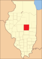
Macon County from 1829 to 1841.
-
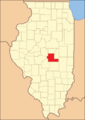
Macon County from 1841 to 1843.
-
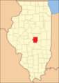
Macon County as it looks today.


Geography and Landscape

Macon County covers about 586 square miles. Most of this area, 581 square miles, is land. The rest, about 5.2 square miles, is water.
The land in Macon County is mostly flat. This is true for much of Illinois and the areas around it. This flat land was formed a long, long time ago by giant sheets of ice called glaciers. During the Ice Age, a huge glacier covered about 85% of Illinois, including Macon County. When the ice melted and moved away, it left behind the flat land we see today.
Because it's right in the middle of Illinois, Macon County is sometimes called "The Heart of Illinois."
Weather and Climate
| Weather chart for Decatur, Illinois | |||||||||||||||||||||||||||||||||||||||||||||||
|---|---|---|---|---|---|---|---|---|---|---|---|---|---|---|---|---|---|---|---|---|---|---|---|---|---|---|---|---|---|---|---|---|---|---|---|---|---|---|---|---|---|---|---|---|---|---|---|
| J | F | M | A | M | J | J | A | S | O | N | D | ||||||||||||||||||||||||||||||||||||
|
2.1
35
17
|
2
41
22
|
3.2
53
32
|
3.6
65
42
|
4.5
76
52
|
3.9
85
61
|
4.5
88
65
|
4.1
86
63
|
3
80
55
|
2.7
68
44
|
3.3
52
34
|
2.9
39
23
|
||||||||||||||||||||||||||||||||||||
| temperatures in °F precipitation totals in inches source: The Weather Channel |
|||||||||||||||||||||||||||||||||||||||||||||||
|
Metric conversion
|
|||||||||||||||||||||||||||||||||||||||||||||||
The weather in Macon County changes with the seasons. In Decatur, the main city, winter temperatures in January can be as low as 17°F. Summer temperatures in July can reach highs of 88°F.
However, temperatures can be much more extreme. The coldest temperature ever recorded was -25°F in February 1905. The hottest was 113°F in July 1954.
The county gets rain and snow throughout the year. February is usually the driest month, with about 1.95 inches of precipitation. July is often the wettest, with about 4.54 inches.
Main Roads and Transportation
Macon County has several important roads that help people travel. These include major highways and local routes.
 Interstate 72
 U.S. Route 36
 U.S. Route 51
 Illinois Route 48
 Illinois Route 105
 Illinois Route 121
 Illinois Route 128
For public transportation, Macon County has the Decatur Public Transit System. There is also a service called SHOW Bus. You can also find stops for buses that travel between cities.
Neighboring Counties
Macon County shares its borders with several other counties. These are:
Population of Macon County
The number of people living in Macon County has changed over many years. Here's how the population has grown and changed since 1830:
| Historical population | |||
|---|---|---|---|
| Census | Pop. | %± | |
| 1830 | 1,122 | — | |
| 1840 | 3,039 | 170.9% | |
| 1850 | 3,988 | 31.2% | |
| 1860 | 13,738 | 244.5% | |
| 1870 | 26,481 | 92.8% | |
| 1880 | 30,665 | 15.8% | |
| 1890 | 38,083 | 24.2% | |
| 1900 | 44,003 | 15.5% | |
| 1910 | 54,186 | 23.1% | |
| 1920 | 65,175 | 20.3% | |
| 1930 | 81,731 | 25.4% | |
| 1940 | 84,693 | 3.6% | |
| 1950 | 98,853 | 16.7% | |
| 1960 | 118,257 | 19.6% | |
| 1970 | 125,010 | 5.7% | |
| 1980 | 131,375 | 5.1% | |
| 1990 | 117,206 | −10.8% | |
| 2000 | 114,706 | −2.1% | |
| 2010 | 110,768 | −3.4% | |
| 2020 | 103,998 | −6.1% | |
| 2023 (est.) | 100,591 | −9.2% | |
| US Decennial Census 1790–1960 1900–1990 1990–2000 2010 |
|||
In 2010, there were 110,768 people living in the county. Most people in Macon County are white, and there is also a significant Black or African American population. People from many different backgrounds and cultures live here.
Towns and Villages
Macon County has several cities, towns, and smaller communities. The largest city is Decatur, which is also the county seat.
Cities
Villages

Census-Designated Place
- Boody (This is a community that is counted in the census but isn't an official city or village.)
Unincorporated Communities
These are smaller communities that don't have their own local government.
Ghost Town
- Whistleville (This is a place where a town used to be, but now it's mostly empty.)
Townships
Townships are smaller areas within the county that help manage local services.
- Austin
- Blue Mound
- Decatur
- Friends Creek
- Harristown
- Hickory Point
- Illini
- Long Creek
- Maroa
- Milam (This township no longer exists.)
- Mount Zion
- Niantic
- Oakley
- Pleasant View
- South Macon
- South Wheatland
- Whitmore
See also
 In Spanish: Condado de Macon (Illinois) para niños
