
Moultrie County, Illinois facts for kids
Quick facts for kids
Moultrie County
|
||
|---|---|---|

Moultrie County Courthouse in Sullivan
|
||
|
||

Location within the U.S. state of Illinois
|
||
 Illinois's location within the U.S. |
||
| Country | ||
| State | ||
| Founded | February 16, 1843 | |
| Named for | William Moultrie | |
| Seat | Sullivan | |
| Largest city | Sullivan | |
| Area | ||
| • Total | 344 sq mi (890 km2) | |
| • Land | 336 sq mi (870 km2) | |
| • Water | 8.5 sq mi (22 km2) 2.5% | |
| Population
(2020)
|
||
| • Total | 14,526 | |
| • Estimate
(2021)
|
14,510 | |
| • Density | 42.23/sq mi (16.304/km2) | |
| Time zone | UTC−6 (Central) | |
| • Summer (DST) | UTC−5 (CDT) | |
| Congressional district | 15th | |

Moultrie County is a county in the state of Illinois, USA. It's like a smaller region within the state. In 2020, about 14,526 people lived here. The main town, or county seat, is Sullivan. The name "Moultrie" is said like "mole tree." This is different from how its namesake, a hero from the American Revolutionary War named William Moultrie, said his name.
Contents
History of Moultrie County
Moultrie County was created in 1843. Land for the county was taken from Shelby and Macon counties. It was named after South Carolina General William Moultrie. General Moultrie was famous for defending Sullivan's Island, South Carolina, from a British attack in 1776. This place was later named Fort Moultrie. Another nearby county, Jasper County, was named for Sergeant William Jasper, who was also a hero at Sullivan's Island.
The official flag of Moultrie County is the Moultrie Flag. General Moultrie designed this flag. It flew over the new fort on Sullivan's Island during the battle. This flag became a symbol of freedom in the southern states.
When some people wanted to create this new county, they needed land from other counties. Macon County gave up some land that was thought to be "worthless swamp." Today, this land is very fertile and good for farming. Shelby and Coles counties didn't want to give up their land at first. But eventually, Shelby County gave some land, which created a zig-zag border with Moultrie County.
-
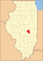
Moultrie County when it was first created in 1843
-
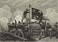
The Moultrie Flag being raised by Sergeant William Jasper


Geography of Moultrie County
Moultrie County covers a total area of 344 square miles. Most of this, 336 square miles, is land. The remaining 8.5 square miles, or 2.5%, is water.
Climate and Weather in Moultrie County
| Weather chart for Sullivan, Illinois | |||||||||||||||||||||||||||||||||||||||||||||||
|---|---|---|---|---|---|---|---|---|---|---|---|---|---|---|---|---|---|---|---|---|---|---|---|---|---|---|---|---|---|---|---|---|---|---|---|---|---|---|---|---|---|---|---|---|---|---|---|
| J | F | M | A | M | J | J | A | S | O | N | D | ||||||||||||||||||||||||||||||||||||
|
2
34
19
|
1.9
41
24
|
3.3
52
33
|
3.7
65
43
|
4
75
53
|
4.1
83
62
|
4
87
66
|
3.3
85
63
|
3.1
80
56
|
3.1
68
45
|
3.9
52
35
|
3
39
24
|
||||||||||||||||||||||||||||||||||||
| temperatures in °F precipitation totals in inches source: The Weather Channel |
|||||||||||||||||||||||||||||||||||||||||||||||
|
Metric conversion
|
|||||||||||||||||||||||||||||||||||||||||||||||
In Sullivan, the county seat, average temperatures change throughout the year. In January, the average low is 19°F. In July, the average high is 87°F. The coldest temperature ever recorded was -26°F in January 1915. The hottest was 111°F in July 1936. The amount of rain and snow also changes. February usually gets about 1.89 inches of precipitation. June gets the most, with about 4.05 inches.
Major Highways in Moultrie County
Several important roads pass through Moultrie County. These highways help people travel to and from different towns.
 U.S. Route 36
 Illinois Route 16
 Illinois Route 32
 Illinois Route 121
 Illinois Route 133
Counties Next to Moultrie County
Moultrie County shares borders with several other counties in Illinois.
- Piatt County to the north
- Douglas County to the east
- Coles County to the southeast
- Shelby County to the south
- Macon County to the northwest
Population and People in Moultrie County
| Historical population | |||
|---|---|---|---|
| Census | Pop. | %± | |
| 1850 | 3,234 | — | |
| 1860 | 6,385 | 97.4% | |
| 1870 | 10,385 | 62.6% | |
| 1880 | 13,699 | 31.9% | |
| 1890 | 14,481 | 5.7% | |
| 1900 | 15,224 | 5.1% | |
| 1910 | 14,630 | −3.9% | |
| 1920 | 14,839 | 1.4% | |
| 1930 | 13,247 | −10.7% | |
| 1940 | 13,477 | 1.7% | |
| 1950 | 13,171 | −2.3% | |
| 1960 | 13,635 | 3.5% | |
| 1970 | 13,263 | −2.7% | |
| 1980 | 14,546 | 9.7% | |
| 1990 | 13,930 | −4.2% | |
| 2000 | 14,287 | 2.6% | |
| 2010 | 14,846 | 3.9% | |
| 2020 | 14,526 | −2.2% | |
| 2023 (est.) | 14,342 | −3.4% | |
| US Decennial Census 1790-1960 1900-1990 1990-2000 2010-2013 2020 |
|||
In 2010, there were 14,846 people living in Moultrie County. Most people, about 98.5%, were white. Small percentages were Black, Asian, or American Indian. About 0.9% of the population was of Hispanic or Latino background. Many families in the county have German, Irish, American, or English roots.
About 31.8% of households had children under 18 living there. Most households, 57.6%, were married couples. The average age of people in the county was about 40 years old. The average income for a household was around $46,364.
Towns and Areas in Moultrie County

Moultrie County has one city, several villages, and some smaller, unincorporated communities. It is also divided into different townships.
City
- Sullivan is the main city and the county seat.
Villages
- Allenville
- Arthur (part of this village is in another county)
- Bethany
- Dalton City
- Gays
- Lovington
Unincorporated Communities
These are smaller places that don't have their own local government.
- Bruce
- Dunn
- Fuller
- Kirksville
- Lake City
Townships
Townships are smaller divisions of the county, often used for local services.
- Dora
- East Nelson
- Jonathan Creek
- Lovington
- Lowe
- Marrowbone
- Sullivan
- Whitley
Education in Moultrie County
Students in Moultrie County attend schools in three different school districts.
- Sullivan Community Unit School District 300
- Okaw Valley Community Unit School District 302
- Arthur-Lovington/Atwood-Hammond Community Unit School District 305
See also
 In Spanish: Condado de Moultrie para niños
