Westervelt, Illinois facts for kids
Quick facts for kids
Westervelt, Illinois
|
|
|---|---|

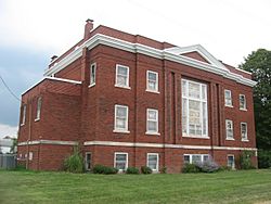
Westervelt Christian Church
|
|
| Country | |
| State | |
| County | Shelby |
| Township | Ridge |
| Area | |
| • Total | 0.09 sq mi (0.22 km2) |
| • Land | 0.09 sq mi (0.22 km2) |
| • Water | 0.00 sq mi (0.00 km2) |
| Elevation | 650 ft (200 m) |
| Population
(2020)
|
|
| • Total | 131 |
| • Density | 1,523.26/sq mi (591.04/km2) |
| Time zone | UTC-6 (Central (CST)) |
| • Summer (DST) | UTC-5 (CDT) |
| ZIP Code |
62565
|
| Area code(s) | 217 |
| GNIS feature ID | 2628563 |
Westervelt is a small community located in Shelby County, Illinois, United States. It is known as a census-designated place, which means it's a specific area identified by the U.S. Census Bureau for statistical purposes. In 2020, about 131 people lived there.
Contents
Discovering Westervelt's Past
Westervelt started in 1904. It began as a train station along the new Chicago and Eastern Illinois Railroad line. This new train stop attracted people and businesses from a nearby town called Brunswick. Because of this, Westervelt quickly grew into a lively community.
A Notable Landmark
The Westervelt Christian Church is a very important building in the area. It is so special that it is listed on the National Register of Historic Places. This means it's recognized for its historical importance.
Facing a Challenge
In 1917, a powerful tornado struck Westervelt. This natural event caused significant damage to the community. It affected many buildings and residents.
Who Lives in Westervelt?
Understanding the population of a place helps us learn about its growth. The U.S. Census Bureau counts how many people live in different areas every ten years.
Population Changes Over Time
Here's how Westervelt's population has changed:
- 2000: 130 people
- 2010: 128 people
- 2020: 131 people
As you can see, the number of people living in Westervelt has stayed quite steady over the years.
See also

- In Spanish: Westervelt (Illinois) para niños
 | Kyle Baker |
 | Joseph Yoakum |
 | Laura Wheeler Waring |
 | Henry Ossawa Tanner |


