
Greene County, Illinois facts for kids
Quick facts for kids
Greene County
|
|
|---|---|

Greene County Courthouse
|
|

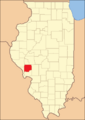
Location within the U.S. state of Illinois
|
|
 Illinois's location within the U.S. |
|
| Country | |
| State | |
| Founded | 1821 |
| Named for | Nathanael Greene |
| Seat | Carrollton |
| Largest city | Carrollton |
| Area | |
| • Total | 546 sq mi (1,410 km2) |
| • Land | 543 sq mi (1,410 km2) |
| • Water | 3.3 sq mi (9 km2) 0.6% |
| Population
(2020)
|
|
| • Total | 11,843 |
| • Density | 21.690/sq mi (8.375/km2) |
| Time zone | UTC−6 (Central) |
| • Summer (DST) | UTC−5 (CDT) |
| Congressional district | 15th |
| Website | https:// |
Greene County is a county in the state of Illinois, USA. In 2020, about 11,843 people lived here. Its main town, or county seat, is Carrollton.
An important archaeological spot called the Koster Site is in Greene County. It shows that people lived here for over 7,000 years! You can see old items from this site at the Center for American Archeology in Kampsville, Illinois.
Contents
History of Greene County
Greene County is named after General Nathanael Greene. He was a hero in the American Revolutionary War. The county was created in 1821. This was just three years after Illinois became a state.
Greene County was first made from parts of Madison and St. Clair counties. Over the next 18 years, four new counties were formed from its land. These were Scott, Morgan, Macoupin, and Jersey counties. This left Greene County with its current size of about 546 square miles. It is located in west-central Illinois, near the Illinois River. The river was very important for travel and shipping goods.
Many of the first settlers came from southern states like North and South Carolina. Others came from Virginia, Kentucky, and Tennessee. By 1860, the population of Greene County had grown to 16,093 people. Many people who lived there had roots in the South.
-
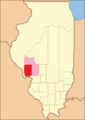
Greene County from 1821 to 1823, including extra land.
-
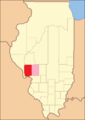
Greene County between 1823 and 1825.
-
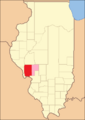
Greene County between 1825 and 1829.
-
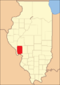
Greene County between 1829 and 1839.
-
Greene County in 1839, after Jersey County was created.


Geography of Greene County
Greene County covers about 546 square miles in total. Most of this area, about 543 square miles, is land. The rest, about 3.3 square miles, is water.
Climate and Weather in Greene County
| Weather chart for Carrollton, Illinois | |||||||||||||||||||||||||||||||||||||||||||||||
|---|---|---|---|---|---|---|---|---|---|---|---|---|---|---|---|---|---|---|---|---|---|---|---|---|---|---|---|---|---|---|---|---|---|---|---|---|---|---|---|---|---|---|---|---|---|---|---|
| J | F | M | A | M | J | J | A | S | O | N | D | ||||||||||||||||||||||||||||||||||||
|
1.6
34
16
|
1.8
40
20
|
3.3
52
30
|
3.6
64
42
|
4.3
74
52
|
3.6
83
61
|
3.4
87
65
|
2.8
85
63
|
3
78
54
|
2.6
67
43
|
3.3
52
32
|
2.6
39
21
|
||||||||||||||||||||||||||||||||||||
| temperatures in °F precipitation totals in inches source: The Weather Channel |
|||||||||||||||||||||||||||||||||||||||||||||||
|
Metric conversion
|
|||||||||||||||||||||||||||||||||||||||||||||||
In Carrollton, the county seat, temperatures change throughout the year. In January, the average low is 16°F. In July, the average high is 87°F. The coldest temperature ever recorded was -26°F in January 1912. The hottest was 113°F in July 1934.
The amount of rain and snow also changes. January usually gets about 1.60 inches of precipitation. May gets the most, with about 4.34 inches.
Main Roads in Greene County
 U.S. Highway 67
 Illinois Route 16
 Illinois Route 100
 Illinois Route 106
 Illinois Route 108
 Illinois Route 267
Neighboring Counties
- Scott County - north
- Morgan County - north
- Macoupin County - east
- Jersey County - south
- Calhoun County - southwest
- Pike County - northwest
Protected Natural Areas
Part of the Two Rivers National Wildlife Refuge is in Greene County. This area helps protect wildlife.
Population of Greene County
| Historical population | |||
|---|---|---|---|
| Census | Pop. | %± | |
| 1830 | 7,674 | — | |
| 1840 | 11,951 | 55.7% | |
| 1850 | 12,429 | 4.0% | |
| 1860 | 16,093 | 29.5% | |
| 1870 | 20,277 | 26.0% | |
| 1880 | 23,010 | 13.5% | |
| 1890 | 23,791 | 3.4% | |
| 1900 | 23,402 | −1.6% | |
| 1910 | 22,363 | −4.4% | |
| 1920 | 22,883 | 2.3% | |
| 1930 | 20,417 | −10.8% | |
| 1940 | 20,292 | −0.6% | |
| 1950 | 18,852 | −7.1% | |
| 1960 | 17,460 | −7.4% | |
| 1970 | 17,014 | −2.6% | |
| 1980 | 16,661 | −2.1% | |
| 1990 | 15,317 | −8.1% | |
| 2000 | 14,761 | −3.6% | |
| 2010 | 13,886 | −5.9% | |
| 2020 | 11,985 | −13.7% | |
| 2023 (est.) | 11,543 | −16.9% | |
| US Decennial Census 1790–1960 1900–1990 1990–2000 2010–2013 |
|||

In 2010, there were 13,886 people living in Greene County. The population density was about 25.6 people per square mile. Most people, about 97.9%, were white. About 0.9% were black or African American.
The average age in the county was 41.6 years old. The average income for a family was about $52,049 per year.
Towns and Villages in Greene County
Cities
Villages
Other Communities
Townships
- Athensville
- Bluffdale
- Carrollton
- Kane
- Linder
- Patterson
- Rockbridge
- Roodhouse
- Rubicon
- Walkerville
- White Hall
- Woodville
- Wrights
Population Ranking of Towns
This table shows how many people lived in each town in Greene County in 2020.
† county seat
| Rank | Place | Type of Town | Population (2020 Census) |
|---|---|---|---|
| 1 | † Carrollton | City | 2,485 |
| 2 | White Hall | City | 2,295 |
| 3 | Roodhouse | City | 1,578 |
| 4 | Greenfield | City | 1,059 |
| 5 | Kane | Village | 296 |
| 6 | Rockbridge | Village | 175 |
| 7 | Eldred | Village | 149 |
| 8 | Hillview | Village | 94 |
| 9 | Wilmington (Patterson) | Village | 91 |
See also
 In Spanish: Condado de Greene (Illinois) para niños
