Kampsville, Illinois facts for kids
Quick facts for kids
Kampsville
|
|
|---|---|

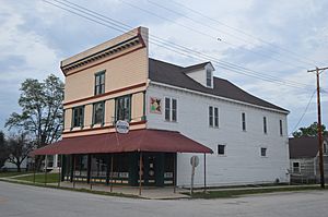
The Kamp Store, a historic site in the village
|
|

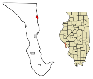
Location of Kampsville in Calhoun County, Illinois.
|
|

Location of Illinois in the United States
|
|
| Country | United States |
| State | Illinois |
| County | Calhoun |
| Area | |
| • Total | 1.24 sq mi (3.21 km2) |
| • Land | 1.02 sq mi (2.64 km2) |
| • Water | 0.22 sq mi (0.57 km2) |
| Elevation | 446 ft (136 m) |
| Population
(2020)
|
|
| • Total | 310 |
| • Density | 250/sq mi (96.6/km2) |
| Time zone | UTC-6 (CST) |
| • Summer (DST) | UTC-5 (CDT) |
| ZIP Code(s) |
62053
|
| Area code(s) | 618 |
| FIPS code | 17-38856 |
| GNIS feature ID | 23983235 |
| Wikimedia Commons | Kampsville, Illinois |
Kampsville is a small village in Calhoun County, Illinois, USA. It's located right on the west bank of the Illinois River. In 2022, about 310 people lived there.
Contents
The Story Behind Kampsville's Name
Kampsville has had a few different names over the years! It was first called Beeman's Landing. This name came from James L. Beeman, who operated a ferry across the Illinois River.
Later, Stephen Farrow bought the ferry, and the village's name changed to Farrowtown. When a post office opened in 1857, the name Vedder was used.
Finally, on March 6, 1872, the name Kampsville became official. It was named after Michael A. Kamp. He was important to the village, serving as president of the village board and also as a postmaster nearby.
What Makes Kampsville Special?
The Kampsville Ferry
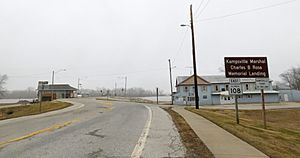
One cool thing about Kampsville is its free ferry! The Kampsville ferry crosses the Illinois River. It connects a part of Illinois Route 108 in Kampsville to the rest of the road in Greene County.
This ferry runs 24 hours a day, seven days a week, and it doesn't cost anything to use! It's one of only two ferries in Illinois that run all the time, operated by the Illinois Department of Transportation.
Exploring Ancient History: The Center for American Archeology
Kampsville is also home to the Center for American Archeology. This is a special place for learning and research. They focus on understanding the history of Native Americans and early European settlers in the area.
The center has amazing exhibits. You can see evidence of people living here for 7,000 years! Many of these discoveries came from the Koster Site, an important archeological dig in nearby Greene County.
Kampsville's Location and Roads
Where is Kampsville?
Kampsville covers about 1.24 square miles (3.21 square kilometers). Most of this area, about 1.02 square miles (2.64 square kilometers), is land. The rest, about 0.22 square miles (0.57 square kilometers), is water.
Highways in the Village
Three main highways pass through Kampsville. These are Route 100, Route 96, and a small part of Route 108. Route 108 is the one that leads directly to the Kampsville ferry.
Who Lives in Kampsville?
| Historical population | |||
|---|---|---|---|
| Census | Pop. | %± | |
| 1880 | 79 | — | |
| 1890 | 172 | 117.7% | |
| 1900 | 330 | 91.9% | |
| 1910 | 506 | 53.3% | |
| 1920 | 428 | −15.4% | |
| 1930 | 388 | −9.3% | |
| 1940 | 432 | 11.3% | |
| 1950 | 437 | 1.2% | |
| 1960 | 453 | 3.7% | |
| 1970 | 439 | −3.1% | |
| 1980 | 423 | −3.6% | |
| 1990 | 399 | −5.7% | |
| 2000 | 302 | −24.3% | |
| 2010 | 328 | 8.6% | |
| 2020 | 310 | −5.5% | |
| U.S. Decennial Census | |||
Population Numbers
According to the 2020 census, 310 people lived in Kampsville. There were 132 households, which means 132 different homes or groups of people living together. Out of these, 96 were families.
The village had about 250 people per square mile (96.5 per square kilometer). There were also 175 housing units, like houses or apartments.
Diversity in Kampsville
Most people in Kampsville were White (91.29%). About 1.29% were Native American, and 7.42% were from two or more races. A small number, 2.58%, were Hispanic or Latino.
Households and Families
In 28.8% of households, there were children under 18 living there. More than half (55.30%) were married couples living together. About 15.15% of households had a female head of the house with no husband present.
The average household had about 2.76 people. The average family had about 2.30 people.
Age Groups
The population in Kampsville includes people of all ages. About 29.3% of the people were under 18 years old. About 23.7% were 65 years old or older. The average age in the village was 39.1 years.
Income Information
The average income for a household in Kampsville was $49,583 per year. For families, the average income was $57,500 per year.
About 26.0% of families and 31.3% of all people in Kampsville lived below the poverty line. This included 56.4% of children under 18 and 15.8% of people aged 65 or older.
Education in Kampsville
Students in Kampsville attend schools within the Calhoun Community Unit School District 40.
See also
 In Spanish: Kampsville para niños
 | Kyle Baker |
 | Joseph Yoakum |
 | Laura Wheeler Waring |
 | Henry Ossawa Tanner |


