Calhoun County, Illinois facts for kids
Quick facts for kids
Calhoun County
|
|
|---|---|

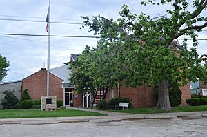
Calhoun County Courthouse in Hardin
|
|

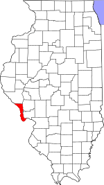
Location within the U.S. state of Illinois
|
|
 Illinois's location within the U.S. |
|
| Country | |
| State | |
| Founded | 1825 |
| Named for | John C. Calhoun |
| Seat | Hardin |
| Largest village | Hardin |
| Area | |
| • Total | 284 sq mi (740 km2) |
| • Land | 254 sq mi (660 km2) |
| • Water | 30 sq mi (80 km2) 10.5% |
| Population
(2020)
|
|
| • Total | 4,437 |
| • Density | 15.623/sq mi (6.032/km2) |
| Time zone | UTC−6 (Central) |
| • Summer (DST) | UTC−5 (CDT) |
| Congressional district | 15th |
Calhoun County is a county in the state of Illinois, USA. In 2020, about 4,437 people lived there. This makes it the third least populated county in Illinois.
The main town and biggest community is Hardin. It has about 801 residents. The smallest town is Hamburg, with only 99 people. Calhoun County is like a long arm of land. It is almost completely surrounded by the Mississippi and Illinois rivers. These two big rivers meet nearby. The county does not have many people. It only has five small towns, all called villages.
Calhoun County is also part of the larger St. Louis area. This area spreads across parts of Missouri and Illinois.
Contents
History of Calhoun County
This area was first home to Native American people. They lived in the rich river valleys for thousands of years. Their old settlements have taught us a lot about early American history. In fact, we know that people lived here for over 10,000 years!
European Americans started settling in Calhoun County in the 1800s. The county was officially created in 1825. It was named after John C. Calhoun, who was a Vice President.
The southern part of the county was covered in thick forests. It stayed mostly untouched until the late 1840s. That's when many German immigrants arrived. They cleared the land for farming. They also cut down trees to sell lumber. These German farmers built large log barns, often about 200 square feet (19 m2) in size. These barns became a sign of successful German farms.
Marquette and Joliet's Journey
There is a statue in Grafton, Illinois, which is south of Calhoun County. It marks where explorers Marquette and Joliet are thought to have landed. This famous exploration happened a long time ago. Historians believe this spot is correct because of Marquette's diary. He wrote that they entered the Illinois River early in the morning. This means they must have camped nearby the night before. The land around Grafton is high and good for camping. The land on the Missouri side is low and swampy.
However, some local historians in Calhoun County have a different idea. They believe the explorers stopped at a place called "Perrin's Ledge." This spot is several miles north of Kampsville, Illinois. Their claims seem to fit Marquette's diary better. He wrote, "We entered the mouth of the Illinois River very early in the morning." He also said, "We spent the night with some friendly Indians."
The explorers usually traveled about 25 miles a day up the Mississippi River. They might have traveled faster on the Illinois River because the current was weaker. If they entered the river early and traveled well, they would have reached the Kampsville area by evening. At Perrin's Ledge, there are several large Indian mounds. Early settlers found signs of a small Native American village there. The bluff at the ledge is very close to the water. The rocks stick out in a way that looks like castle walls from far away. It is very likely that Marquette and Joliet stopped here for the night.
Geography of Calhoun County
Calhoun County covers about 284 square miles (740 km2). About 254 square miles (660 km2) is land, and 30 square miles (78 km2) (10.5%) is water.
It is a long, narrow piece of land, about 37-mile (60 km) long. It sits between the Mississippi River and the Illinois River. The land here has rolling hills. These hills were not flattened by glaciers long ago.
To travel around the county, people use ferries. Two free ferries cross the Illinois River. These are the Brussels Ferry in the south and the Kampsville Ferry in the north. There is also a private ferry called The Golden Eagle. It charges a fee and crosses the Mississippi River to St. Charles County, Missouri. A bridge also crosses the Illinois River at Hardin. You can also travel north by land to Pike County.
In the past, when most travel was by river, the county had many successful farms and orchards. Today, it still grows a lot of Illinois's peach crop. Farmers also grow corn and other foods. The hotel in Brussels was built in 1847. It used to be a stop for stagecoaches.
Many tourists visit Calhoun County. They enjoy the beautiful nature of the Illinois River valley. The county is also near the Great River Road. Part of the Two Rivers National Wildlife Refuge is here. This refuge attracts thousands of birds during their migration seasons. It is part of the Mississippi Flyway, a major bird migration route. The county also has several historic areas and buildings. These are listed on the National Register of Historic Places.
In 2003, Calhoun County became part of the St. Louis Metropolitan Statistical Area. This means it is counted as part of the larger St. Louis city area.
The Center for American Archeology is in Kampsville. This center studies the history of prehistoric Native American cultures in the area. They offer learning programs for kids and adults. You can even join their archaeological digs!
Neighboring Counties
- Greene County – northeast
- Jersey County – east
- St. Charles County, Missouri – south
- Lincoln County, Missouri – west
- Pike County, Illinois – north
- Pike County, Missouri – northwest
Protected Natural Area
- Two Rivers National Wildlife Refuge (part of it)
Main Roads
Climate and Weather
| Weather chart for Hardin, Illinois | |||||||||||||||||||||||||||||||||||||||||||||||
|---|---|---|---|---|---|---|---|---|---|---|---|---|---|---|---|---|---|---|---|---|---|---|---|---|---|---|---|---|---|---|---|---|---|---|---|---|---|---|---|---|---|---|---|---|---|---|---|
| J | F | M | A | M | J | J | A | S | O | N | D | ||||||||||||||||||||||||||||||||||||
|
2
39
19
|
2
46
24
|
3.5
58
33
|
3.8
70
43
|
4.1
78
52
|
3.5
86
61
|
3.4
90
66
|
3.2
88
63
|
3.3
81
55
|
2.8
70
44
|
3.5
56
35
|
3
43
24
|
||||||||||||||||||||||||||||||||||||
| temperatures in °F precipitation totals in inches source: The Weather Channel |
|||||||||||||||||||||||||||||||||||||||||||||||
|
Metric conversion
|
|||||||||||||||||||||||||||||||||||||||||||||||
The weather in Hardin, the county seat, changes a lot. In January, the average low temperature is about 19 °F (−7 °C). In July, the average high is about 90 °F (32 °C). The coldest temperature ever recorded was −24 °F (−31 °C) in January 1979. The hottest was 116 °F (47 °C) in July 1954.
The county gets rain throughout the year. On average, it rains least in January, about 2.01 inches (51 mm). May is usually the wettest month, with about 4.10 inches (104 mm) of rain.
Population Information
| Historical population | |||
|---|---|---|---|
| Census | Pop. | %± | |
| 1830 | 1,090 | — | |
| 1840 | 1,740 | 59.6% | |
| 1850 | 3,231 | 85.7% | |
| 1860 | 5,144 | 59.2% | |
| 1870 | 6,562 | 27.6% | |
| 1880 | 7,467 | 13.8% | |
| 1890 | 7,652 | 2.5% | |
| 1900 | 8,917 | 16.5% | |
| 1910 | 8,610 | −3.4% | |
| 1920 | 8,245 | −4.2% | |
| 1930 | 8,034 | −2.6% | |
| 1940 | 8,207 | 2.2% | |
| 1950 | 6,898 | −15.9% | |
| 1960 | 5,933 | −14.0% | |
| 1970 | 5,675 | −4.3% | |
| 1980 | 5,867 | 3.4% | |
| 1990 | 5,322 | −9.3% | |
| 2000 | 5,084 | −4.5% | |
| 2010 | 5,089 | 0.1% | |
| 2020 | 4,437 | −12.8% | |
| 2023 (est.) | 4,317 | −15.2% | |
| U.S. Decennial Census 1790-1960 1900-1990 1990-2000 2010 |
|||
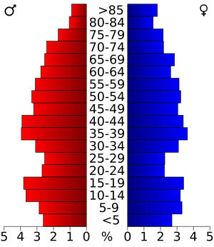
In 2010, there were 5,089 people living in Calhoun County. There were 2,085 households, which are groups of people living together. The population density was about 20 people per square mile.
Most people in the county are white (98.9%). A small number are Asian, American Indian, or Black. About 0.8% of the population is of Hispanic or Latino background. Many people have German roots (46.2%). Others have American, Irish, or English ancestry.
About 28% of households had children under 18 living with them. Most households (59.2%) were married couples. The average age of people in the county was 44.6 years old.
The average income for a household was about $44,891 per year. For families, it was about $57,627. About 11.7% of all people in the county lived below the poverty line. This included 12.3% of those under 18.
Communities in Calhoun County
Villages
Unincorporated Communities
Education
Several school districts serve Calhoun County:
- Brussels Community Unit School District 42
- Calhoun Community Unit School District 40
- Pikeland Community Unit School District 10
- Pleasant Hill Community Unit School District 3
See also
 In Spanish: Condado de Calhoun (Illinois) para niños
 | William Lucy |
 | Charles Hayes |
 | Cleveland Robinson |


