Eldred, Illinois facts for kids
Quick facts for kids
Eldred, Illinois
|
|
|---|---|

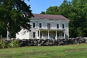
James John Eldred House north of Eldred
|
|

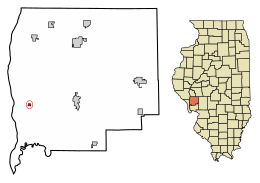
Location of Eldred in Greene County, Illinois.
|
|

Location of Illinois in the United States
|
|
| Country | United States |
| State | Illinois |
| County | Greene |
| Area | |
| • Total | 0.13 sq mi (0.35 km2) |
| • Land | 0.13 sq mi (0.35 km2) |
| • Water | 0.00 sq mi (0.00 km2) |
| Elevation | 446 ft (136 m) |
| Population
(2020)
|
|
| • Total | 149 |
| • Density | 1,111.94/sq mi (430.17/km2) |
| Time zone | UTC-6 (CST) |
| • Summer (DST) | UTC-5 (CDT) |
| ZIP Code(s) |
62027
|
| Area code(s) | 217 |
| GNIS ID | 2398797 |
| FIPS code | 17-23022 |
| Wikimedia Commons | Eldred, Illinois |
Eldred is a small village located in Greene County, Illinois, in the United States. In 2020, about 149 people lived there. It is known for its location near the Illinois River.
Contents
History of Eldred Village
Eldred was established because of its special location. It sits where the Illinois River meets tall bluffs. This made it a good spot for a town that used both the river and the higher land.
The village first appeared on river maps as "Farrow Town" in the 1830s. However, it was founded even earlier, before Illinois became a state in 1818. Some of the first people who settled there were from Scotch-Irish families. They came from the southern parts of the United States.
Geography and Location
Eldred is found in the southwestern part of Greene County. Its exact spot is 39°17′12″N 90°33′12″W / 39.28667°N 90.55333°W. Illinois Route 108 goes right through the village.
This road leads east about 8 miles (13 km) to Carrollton. Carrollton is the main town of Greene County. If you go west about 3 miles (5 km), you will reach the Illinois River. There, you can find the Kampsville ferry.
Land and Water Around Eldred
According to records from 2021, Eldred covers a total area of about 0.13 square miles (0.34 square kilometers). All of this area is land.
Eldred is in the lower Illinois River Valley. It is about 30 miles (48 km) north of where the Illinois River joins the Mississippi River at Grafton. The village is tucked between tall limestone cliffs and rich, flat land. This flat land follows the Illinois River in its southern part.
During the 1920s, the flat river lands were drained to create more farms. This change created a large area of farmland for the counties along the river.
People and Population Changes
| Historical population | |||
|---|---|---|---|
| Census | Pop. | %± | |
| 1910 | 241 | — | |
| 1920 | 298 | 23.7% | |
| 1930 | 282 | −5.4% | |
| 1940 | 340 | 20.6% | |
| 1950 | 298 | −12.4% | |
| 1960 | 302 | 1.3% | |
| 1970 | 292 | −3.3% | |
| 1980 | 286 | −2.1% | |
| 1990 | 254 | −11.2% | |
| 2000 | 211 | −16.9% | |
| 2010 | 201 | −4.7% | |
| 2020 | 149 | −25.9% | |
| U.S. Decennial Census | |||
The 2020 census showed that 149 people lived in Eldred. There were 113 households and 46 families in the village. The village has about 1,112 people per square mile (430 per square kilometer).
Most people in Eldred are White, making up about 94.63% of the population. A small number of people are from other racial backgrounds.
Households and Age in Eldred
Out of the 113 households, a small number (5.3%) had children under 18 living with them. About 30% of households were married couples. Many households (57.52%) had only one person living there. Almost half (46.90%) of these single-person households were people aged 65 or older.
The average age in Eldred was 56.5 years. About 7.4% of the population was under 18 years old. About 39.2% of the people were 65 years or older.
The average income for a household in Eldred was $41,875. For families, the average income was $92,750. About 9.8% of all people in Eldred lived below the poverty line. This included 13.8% of those aged 65 or older.
See also
 In Spanish: Eldred (Illinois) para niños
 | May Edward Chinn |
 | Rebecca Cole |
 | Alexa Canady |
 | Dorothy Lavinia Brown |

