Alhambra, Illinois facts for kids
Quick facts for kids
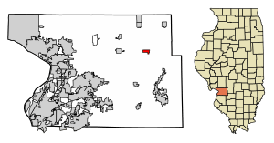
Alhambra, Illinois
|
|
|---|---|

Location in Madison County, Illinois
|
|
| Country | United States |
| State | Illinois |
| County | Madison |
| Township | Alhambra |
| Area | |
| • Total | 0.76 sq mi (1.98 km2) |
| • Land | 0.76 sq mi (1.96 km2) |
| • Water | 0.01 sq mi (0.02 km2) |
| Elevation | 558 ft (170 m) |
| Population
(2020)
|
|
| • Total | 622 |
| • Density | 822.75/sq mi (317.86/km2) |
| Time zone | UTC-6 (CST) |
| • Summer (DST) | UTC-5 (CDT) |
| ZIP code |
62001
|
| Area code(s) | 618 |
| FIPS code | 17-00737 |
| GNIS feature ID | 2397932 |
Alhambra is a small village located in Madison County, Illinois, in the United States. It's part of the Metro-East region, which is near St. Louis, Missouri. In 2020, about 622 people lived there.
History of Alhambra
Alhambra was first planned out in 1849. Its name comes from a famous book called Tales of the Alhambra by Washington Irving.
A very important event in the village's history happened in 1945. The Alhambra Grain & Feed Co. started making products from soybeans. This was the first time a group of farmers worked together to process soybeans in Illinois!
Alhambra's Geography
Alhambra is in the northeastern part of Madison County. You can find it at these coordinates: 38°53′19″N 89°43′57″W / 38.88861°N 89.73250°W.
Illinois Route 140 runs right through the village. It's called Main Street there. This road connects Alhambra to other towns. You can go west about 6 miles to Hamel. Or, you can go east about 17 miles to Greenville. The big city of St. Louis, Missouri is about 36 miles southwest.
The U.S. Census Bureau says Alhambra covers about 0.76 square miles. Most of this area is land, but a tiny bit (about 0.01 square miles) is water. The village's water flows southwest into Silver Creek. This creek then joins the Kaskaskia River.
Population Facts
| Historical population | |||
|---|---|---|---|
| Census | Pop. | %± | |
| 1870 | 101 | — | |
| 1880 | 168 | 66.3% | |
| 1900 | 368 | — | |
| 1910 | 433 | 17.7% | |
| 1920 | 354 | −18.2% | |
| 1930 | 355 | 0.3% | |
| 1940 | 375 | 5.6% | |
| 1950 | 476 | 26.9% | |
| 1960 | 537 | 12.8% | |
| 1970 | 594 | 10.6% | |
| 1980 | 643 | 8.2% | |
| 1990 | 709 | 10.3% | |
| 2000 | 630 | −11.1% | |
| 2010 | 681 | 8.1% | |
| 2020 | 622 | −8.7% | |
| U.S. Decennial Census | |||
In the year 2000, there were 630 people living in Alhambra. These people lived in 209 different homes, and 145 of these were families. The village had about 834 people per square mile.
Most of the people living in Alhambra in 2000 were White (98.73%). A small percentage (1.27%) were from two or more racial backgrounds.
Let's look at the age groups in the village in 2000:
- 17.1% of people were under 18 years old.
- 6.5% were between 18 and 24 years old.
- 22.9% were between 25 and 44 years old.
- 19.5% were between 45 and 64 years old.
- 34.0% were 65 years old or older.
The average age in Alhambra in 2000 was 48 years.
See also
 In Spanish: Alhambra (Illinois) para niños
 | Delilah Pierce |
 | Gordon Parks |
 | Augusta Savage |
 | Charles Ethan Porter |


