
Clay County, Illinois facts for kids
Quick facts for kids
Clay County
|
|
|---|---|

Clay County Courthouse in Louisville
|
|

Location within the U.S. state of Illinois
|
|
 Illinois's location within the U.S. |
|
| Country | |
| State | |
| Founded | December 23, 1824 (created) March 8, 1825 (organized) |
| Named for | Henry Clay |
| Seat | Louisville |
| Largest city | Flora |
| Area | |
| • Total | 469.59 sq mi (1,216.2 km2) |
| • Land | 468.32 sq mi (1,212.9 km2) |
| • Water | 1.28 sq mi (3.3 km2) 0.3% |
| Population
(2020)
|
|
| • Total | 13,288 |
| • Estimate
(2023)
|
12,999 |
| • Density | 28.2970/sq mi (10.9255/km2) |
| Time zone | UTC−6 (Central) |
| • Summer (DST) | UTC−5 (CDT) |
| Congressional district | 12th |
Clay County is a place in the southeastern part of Illinois, a state in the United States. In 2020, about 13,288 people lived here. The main town, called the county seat, is Louisville. It has been the county seat since 1842 and is located right in the middle of the county.
Contents
History of Clay County
For thousands of years, the land that is now Clay County was home to the Illiniwek people. You can still see the remains of one of their old villages west of Ingraham.
Later, explorers from Europe used a path that connected Saint Louis, Missouri, to Vincennes, Indiana. This path became a mail route in 1805. The first American settler from Kentucky built a cabin here in 1809. Other cabins were built, and the area was first called Habbardsville. The Illiniwek people moved from the area in 1828.
Clay County was officially created on December 23, 1824, by the state government. It was formed from parts of Wayne, Crawford, and Fayette counties. The county was named after Henry Clay, a famous American politician from Kentucky. He was a United States Senator and also served as the United States Secretary of State.
The first county leaders met on March 8, 1825, to set up the county government. Land was given for county buildings near Habbardsville. The leaders accepted the land and renamed the area Maysville. By the end of that year, a small courthouse was built. The county government stayed in Maysville until 1841. In 1842, it moved to Louisville, which was more central to the county.
The first railroad line, called the Ohio and Mississippi Line, was built through Clay County between 1850 and 1854. A few years later, the Illinois Central Railroad also built tracks across the northwest part of the county.
Geography of Clay County
-
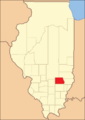
Clay County when it was first created in 1824.
-
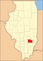
Clay County between 1831 and 1841.
-
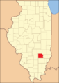
Clay County became its current size in 1841.


Clay County has gentle, rolling hills that are mostly used for farming. The areas around rivers and streams are still quite wooded. The Little Wabash River flows through the middle of the county towards the southeast. Muddy Creek drains the eastern part of the county.
The highest point in the county is about 646 feet (197 meters) above sea level. This spot is along the western border with Marion County. In the past, the county had excellent timber (wood) and some sandstone and limestone. The soil is light and good for farming.
The county covers about 470 square miles (1,217 square kilometers). Most of this area, about 468 square miles (1,212 square kilometers), is land. Only a small part, about 1.3 square miles (3.4 square kilometers), is water.
Neighboring Counties
- Effingham County - north
- Jasper County - northeast
- Richland County - east
- Wayne County - south
- Marion County - west
- Fayette County - northwest
Main Roads
 I-57
I-57 US 45
US 45 US 50
US 50 IL 37
IL 37
Protected Natural Areas
- Martin T Snyder Memorial Nature Preserve
Cities in Clay County
Villages in Clay County
- Clay City
- Iola
- Louisville (county seat)
- Sailor Springs
- Xenia
Unincorporated Communities
These are smaller communities that are not officially cities or villages.
Townships
Townships are smaller divisions within the county.
- Bible Grove
- Blair
- Clay City
- Harter
- Hoosier
- Larkinsburg
- Louisville
- Oskaloosa
- Pixley
- Songer
- Stanford
- Xenia
Climate and Weather
| Weather chart for Louisville, Illinois | |||||||||||||||||||||||||||||||||||||||||||||||
|---|---|---|---|---|---|---|---|---|---|---|---|---|---|---|---|---|---|---|---|---|---|---|---|---|---|---|---|---|---|---|---|---|---|---|---|---|---|---|---|---|---|---|---|---|---|---|---|
| J | F | M | A | M | J | J | A | S | O | N | D | ||||||||||||||||||||||||||||||||||||
|
2.7
38
21
|
2.5
44
25
|
4
55
34
|
4.1
67
43
|
4.3
76
53
|
4.3
85
62
|
3.9
89
65
|
3.3
87
63
|
3.2
80
56
|
3
69
45
|
4.1
55
35
|
3.4
43
25
|
||||||||||||||||||||||||||||||||||||
| temperatures in °F precipitation totals in inches source: The Weather Channel |
|||||||||||||||||||||||||||||||||||||||||||||||
|
Metric conversion
|
|||||||||||||||||||||||||||||||||||||||||||||||
In Louisville, the county seat, the average temperatures usually range from about 21°F (about -6°C) in January to 89°F (about 32°C) in July. The coldest temperature ever recorded was -25°F (-32°C) in January 1904. The hottest was 111°F (44°C) in July 1936.
The amount of rain and snow (precipitation) changes throughout the year. On average, February is the driest month with about 2.49 inches (63 mm) of precipitation. June is usually the wettest, with about 4.34 inches (110 mm).
People of Clay County (Demographics)
| Historical population | |||
|---|---|---|---|
| Census | Pop. | %± | |
| 1830 | 755 | — | |
| 1840 | 3,228 | 327.5% | |
| 1850 | 4,289 | 32.9% | |
| 1860 | 9,336 | 117.7% | |
| 1870 | 15,875 | 70.0% | |
| 1880 | 16,192 | 2.0% | |
| 1890 | 16,772 | 3.6% | |
| 1900 | 19,553 | 16.6% | |
| 1910 | 18,661 | −4.6% | |
| 1920 | 17,684 | −5.2% | |
| 1930 | 16,155 | −8.6% | |
| 1940 | 18,947 | 17.3% | |
| 1950 | 17,445 | −7.9% | |
| 1960 | 15,815 | −9.3% | |
| 1970 | 14,735 | −6.8% | |
| 1980 | 15,283 | 3.7% | |
| 1990 | 14,460 | −5.4% | |
| 2000 | 14,560 | 0.7% | |
| 2010 | 13,815 | −5.1% | |
| 2020 | 13,288 | −3.8% | |
| 2023 (est.) | 12,999 | −5.9% | |
| US Decennial Census 1790-1960 1900-1990 1990-2000 2010 |
|||

A census is a count of the population. In the 2010 census, there were 13,815 people living in Clay County. There were 5,697 households (groups of people living together) and 3,790 families. The county had about 29.5 people per square mile.
Most people in the county (97.7%) were white. About 0.5% were Asian, and 0.3% were black or African American. About 1.1% of the population was of Hispanic or Latino background. Many people in Clay County have German (21.7%), American (14.6%), Irish (12.6%), or English (8.6%) family backgrounds.
About 29.5% of households had children under 18 living with them. The average age of people in the county was 42.2 years old.
The average yearly income for a household in the county was $38,016. For families, it was $48,659. About 16.3% of all people in the county lived below the poverty line. This included 21.4% of those under 18 and 14.7% of those aged 65 or older.
Education
Clay County has several school districts that serve its communities.
- Clay City Community Unit District 10
- Dieterich Community Unit School District 30
- Effingham Community Unit School District 40
- Flora Community Unit School District 35
- Jasper County Community Unit School District 1
- North Clay Community Unit School District 25
- North Clay High School
- South Central Community Unit School District 401
See also
 In Spanish: Condado de Clay (Illinois) para niños
