Xenia, Illinois facts for kids
Quick facts for kids
Xenia, Illinois
|
|
|---|---|

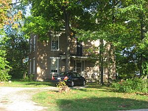
The Paine House, a historic site
|
|

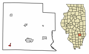
Location of Xenia in Clay County, Illinois.
|
|

Location of Illinois in the United States
|
|
| Country | United States |
| State | Illinois |
| County | Clay |
| Township | Xenia |
| Area | |
| • Total | 0.49 sq mi (1.28 km2) |
| • Land | 0.49 sq mi (1.28 km2) |
| • Water | 0.00 sq mi (0.00 km2) |
| Elevation | 538 ft (164 m) |
| Population
(2020)
|
|
| • Total | 380 |
| • Density | 770.79/sq mi (297.52/km2) |
| Time zone | UTC-6 (CST) |
| • Summer (DST) | UTC-5 (CDT) |
| Zip code |
62899
|
| Area code(s) | 618 |
| FIPS code | 17-83739 |
Xenia (pronounced ZEE-nee-uh) is a small village located in Clay County, Illinois, in the United States. In 2020, about 380 people lived there.
Contents
About Xenia, Illinois
Where is Xenia?
Xenia is in the southwestern part of Clay County. It's located at coordinates 38°38′15″N 88°38′15″W.
A major road, U.S. Route 50, runs just north of the village. If you travel east on this road, you'll reach Flora in about 9 miles. If you go west, you'll get to Salem in about 17 miles.
The village covers a total area of about 0.49 square miles (1.28 square kilometers), and all of it is land.
A Brief History of Xenia
Long ago, this area was home to hunting camps. Two hunters, Kiffcart and Retherford, had their camps in the southwest part of what is now Section 4. A wide buffalo trail also passed through this area.
In 1830, a man named Lewis sold his land to Dr. Davenport. A post office was then set up at the Davenport home with the help of John Pierce and John Gowdy. This is how the town of Xenia officially began.
The town grew a lot when the railroad was built in 1854. By 1870, Xenia's population had grown to 1,000 people. In 1984, the town celebrated its 150th anniversary!
People of Xenia
Population Changes Over Time
The number of people living in Xenia has changed quite a bit over the years. Here's a look at how the population has grown and shrunk:
| Historical population | |||
|---|---|---|---|
| Census | Pop. | %± | |
| 1860 | 472 | — | |
| 1870 | 916 | 94.1% | |
| 1880 | 898 | −2.0% | |
| 1890 | 878 | −2.2% | |
| 1900 | 800 | −8.9% | |
| 1910 | 634 | −20.7% | |
| 1920 | 640 | 0.9% | |
| 1930 | 559 | −12.7% | |
| 1940 | 662 | 18.4% | |
| 1950 | 643 | −2.9% | |
| 1960 | 491 | −23.6% | |
| 1970 | 464 | −5.5% | |
| 1980 | 475 | 2.4% | |
| 1990 | 424 | −10.7% | |
| 2000 | 407 | −4.0% | |
| 2010 | 391 | −3.9% | |
| 2020 | 380 | −2.8% | |
| U.S. Decennial Census | |||
Who Lives in Xenia Today?
According to the 2020 census, there were 380 people living in Xenia. These people made up 156 households, and 85 of those were families.
Most residents, about 91.58%, identified as White. There were also small percentages of Native American, Asian, and people from two or more races. About 3.68% of the population identified as Hispanic or Latino.
Many households (28.8%) had children under 18 living with them. About 42.95% were married couples. The average household had about 3.32 people, and the average family had 2.34 people.
Age and Income
The people in Xenia are of various ages:
- 29.6% were under 18 years old.
- 8.5% were between 18 and 24.
- 21.4% were between 25 and 44.
- 21.1% were between 45 and 64.
- 19.5% were 65 years or older.
The average age in the village was 35.5 years.
The median income for a household in Xenia was $44,167. For families, the median income was $68,750. The average income per person in the village was $21,818. About 14.2% of the population lived below the poverty line.
Notable People from Xenia
- Darren Bailey: He is an Illinois state senator. He also ran for governor of Illinois in 2022.
- Albert Paine: (1861-1937) He was a famous author and wrote biographies.
See also
 In Spanish: Xenia (Illinois) para niños
 | Janet Taylor Pickett |
 | Synthia Saint James |
 | Howardena Pindell |
 | Faith Ringgold |

