
Sullivan County, Indiana facts for kids
Quick facts for kids
Sullivan County
|
|
|---|---|

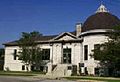
Sullivan County Courthouse
|
|

Location within the U.S. state of Indiana
|
|
 Indiana's location within the U.S. |
|
| Country | |
| State | |
| Founded | January 15, 1817 (created) February 1817 (organized) |
| Named for | General Daniel Sullivan |
| Seat | Sullivan |
| Largest city | Sullivan |
| Area | |
| • Total | 454.12 sq mi (1,176.2 km2) |
| • Land | 447.14 sq mi (1,158.1 km2) |
| • Water | 6.97 sq mi (18.1 km2) 1.53%% |
| Population
(2020)
|
|
| • Total | 20,817 |
| • Estimate
(2023)
|
20,757 |
| • Density | 45.8403/sq mi (17.6990/km2) |
| Time zone | UTC−5 (Eastern) |
| • Summer (DST) | UTC−4 (EDT) |
| Congressional district | 8th |
| Indiana county number 77 | |
Sullivan County is a county located in the state of Indiana, in the United States. In 1940, the US Census Bureau found that the exact middle point of the U.S. population was in Sullivan County. This means that if you gathered all Americans, their average location would have been here!
As of 2023, about 20,757 people live in Sullivan County. The main town and county seat (the place where the county government is) is Sullivan. Sullivan County is also part of the larger Terre Haute metropolitan area.
Contents
Exploring Sullivan County's Past
Sullivan County has a rich history with many interesting events.
Early Days and Important Battles
In 1779, a brave American soldier named Colonel George Rogers Clark captured Fort Sackville from the British. This fort was in Vincennes, not far from Sullivan County. A few days later, Captain Leonard Helm and 50 volunteers captured seven British boats on the Wabash River. This victory helped the Americans take control of the Wabash Valley.
First Settlers: The Shakers
The first group to settle in Sullivan County was a religious community called the Shakers. Between 1808 and 1812, about 400 Shakers lived on 1300 acres of land. They lived a simple, shared life.
General Harrison's Camp
In 1811, General William Henry Harrison and his army camped in Sullivan County at a place called Big Springs. This was a good spot because it had fresh spring water for his 1000 soldiers. Harrison was on his way to build Fort Harrison and then fight in the famous Battle of Tippecanoe.
War of 1812 Ambush
During the War of 1812, a small group of American soldiers faced danger in Sullivan County. In 1812, Sergeant Nathan Fairbanks and about a dozen soldiers were ambushed by Native Americans while carrying supplies. Most of the soldiers were killed.
How Sullivan County Was Formed
Sullivan County was officially created in 1817. It was named after General Daniel Sullivan. Some stories say he was a general in the American Revolutionary War who was killed by Native Americans.
Early County Seats
From 1819 to 1842, a log courthouse in Merom served as the first county seat. Merom was a busy river port and a stop on an old travel route. Later, in 1853, Sullivan became the new county seat.
A Pioneer of Surgery
Sullivan County is also where Jane Todd, a pioneer in abdominal surgery, is buried. In 1809, she traveled 60 miles to have a large tumor removed. Dr. Ephraim McDowell performed this surgery, which had never been done before. Jane Todd recovered completely and lived many more years.
Union Christian College
Union Christian College opened in Merom in 1862. It was a school and college until 1924. Today, it is called Merom Institute and serves as a camp and retreat center.
Chautauqua Events
Merom hosted special 10-day events called Chautauqua. These events brought culture to rural areas with concerts, debates, plays, and lectures. Famous people like Carrie Nation and William Jennings Bryan spoke there.
Sullivan County Park and Lake
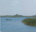
In 1968, the Sullivan County Park and Lake was created. It has a 468-acre reservoir where people can swim, boat, and fish. The lake is home to fish like crappie, bass, and channel catfish. There's also a large area for camping and a 9-hole golf course.
Where is Sullivan County?
Sullivan County covers about 454 square miles. Most of this area, about 447 square miles, is land, and about 7 square miles is water.
Towns and Cities in Sullivan County
Smaller Communities and Neighborhoods
|
|
|
Nearby Counties
Sullivan County shares borders with several other counties:
- Vigo County (to the north)
- Clay County (to the northeast)
- Greene County (to the east)
- Knox County (to the south)
- Crawford County, Illinois (to the west)
- Clark County, Illinois (to the northwest)
Getting Around Sullivan County
Main Roads
 U.S. Route 41
 U.S. Route 150
 State Road 48
 State Road 54
 State Road 58
 State Road 63
 State Road 154
 State Road 159
Airport
Sullivan County has its own airport, the Sullivan County Airport (SIV), located in Sullivan.
What Drives the Economy?
One of the biggest parts of the economy in Sullivan County is coal mining. The Bear Run mine, run by Peabody Energy Corporation, is one of the largest surface coal mines in the eastern U.S. It used to produce a lot of coal and employed many people. However, as the demand for coal has changed, its production has decreased.
Learning in Sullivan County
Sullivan County has two main school systems: the Southwest School Corporation and the Northeast School Corporation.
- Southwest School Corporation's high school is Sullivan High School in Sullivan.
- Northeast School Corporation has two high schools: North Central High School in Farmersburg and Union High School in Dugger.
Weather in Sullivan County
| Weather chart for Sullivan, Indiana | |||||||||||||||||||||||||||||||||||||||||||||||
|---|---|---|---|---|---|---|---|---|---|---|---|---|---|---|---|---|---|---|---|---|---|---|---|---|---|---|---|---|---|---|---|---|---|---|---|---|---|---|---|---|---|---|---|---|---|---|---|
| J | F | M | A | M | J | J | A | S | O | N | D | ||||||||||||||||||||||||||||||||||||
|
2.8
36
18
|
2.6
42
22
|
3.2
52
31
|
4.2
64
42
|
4.1
73
52
|
3.5
82
61
|
4.7
85
65
|
3.8
84
63
|
3.7
78
56
|
3
67
44
|
4.1
53
34
|
3
40
23
|
||||||||||||||||||||||||||||||||||||
| temperatures in °F precipitation totals in inches source: The Weather Channel |
|||||||||||||||||||||||||||||||||||||||||||||||
|
Metric conversion
|
|||||||||||||||||||||||||||||||||||||||||||||||
The weather in Sullivan County changes throughout the year. In January, the average low temperature is about 18°F, and in July, the average high is about 85°F. However, temperatures can be much colder or hotter. The record low was -33°F in January 1994, and the record high was 98°F in July 1999.
The amount of rain and snow also varies. February usually has the least precipitation, while July often has the most.
Population Over Time
| Historical population | |||
|---|---|---|---|
| Census | Pop. | %± | |
| 1820 | 3,498 | — | |
| 1830 | 4,630 | 32.4% | |
| 1840 | 8,315 | 79.6% | |
| 1850 | 10,141 | 22.0% | |
| 1860 | 15,064 | 48.5% | |
| 1870 | 18,453 | 22.5% | |
| 1880 | 20,336 | 10.2% | |
| 1890 | 21,877 | 7.6% | |
| 1900 | 26,005 | 18.9% | |
| 1910 | 32,439 | 24.7% | |
| 1920 | 31,630 | −2.5% | |
| 1930 | 28,133 | −11.1% | |
| 1940 | 27,014 | −4.0% | |
| 1950 | 23,667 | −12.4% | |
| 1960 | 21,721 | −8.2% | |
| 1970 | 19,889 | −8.4% | |
| 1980 | 21,107 | 6.1% | |
| 1990 | 18,993 | −10.0% | |
| 2000 | 21,751 | 14.5% | |
| 2010 | 21,475 | −1.3% | |
| 2020 | 20,817 | −3.1% | |
| 2023 (est.) | 20,757 | −3.3% | |
| US Decennial Census 1790-1960 1900-1990 1990-2000 2010-2021 |
|||
Who Lives in Sullivan County?
Based on the 2010 census, there were 21,475 people living in Sullivan County. Most residents (93.7%) were white. About 4.5% were black or African American. People of Hispanic or Latino origin made up 1.4% of the population.
The average household had about 2.45 people. Many households (53.4%) were married couples living together. The average age of people in the county was about 39.8 years old.
Images for kids
-
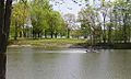
Turtle Creek Reservoir
-
Boating on Sullivan County Park & Lake
-
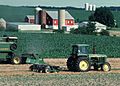
A farm in Sullivan County
-
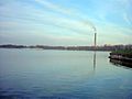
Merom Power Station
-
Sullivan Public Library
.png)
.jpg)

.jpg)

See also
 In Spanish: Condado de Sullivan (Indiana) para niños
