Clay County, Indiana facts for kids
Quick facts for kids
Clay County
|
|
|---|---|

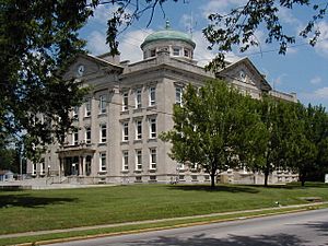
Clay County Courthouse, Brazil
|
|

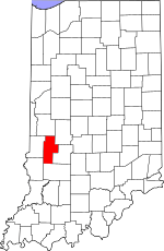
Location within the U.S. state of Indiana
|
|
 Indiana's location within the U.S. |
|
| Country | |
| State | |
| Founded | February 12, 1825 |
| Named for | Henry Clay |
| Seat | Brazil |
| Largest city | Brazil |
| Area | |
| • Total | 360.32 sq mi (933.2 km2) |
| • Land | 357.54 sq mi (926.0 km2) |
| • Water | 2.78 sq mi (7.2 km2) 0.77%% |
| Population
(2020)
|
|
| • Total | 26,466 |
| • Estimate
(2023)
|
26,460 |
| • Density | 73.4514/sq mi (28.3597/km2) |
| Time zone | UTC−5 (Eastern) |
| • Summer (DST) | UTC−4 (EDT) |
| Congressional district | 8th |
| Indiana county number 11 | |
Clay County is a county in the state of Indiana, USA. A county is like a smaller region within a state. In 2020, about 26,466 people lived here. The main town, or county seat, where the county government is located, is Brazil. Clay County is part of the larger Terre Haute area.
Contents
History of Clay County
How Clay County Started
Clay County was officially created by the Indiana Legislature on February 12, 1825. Its land came from parts of other nearby counties: Owen, Putnam, Sullivan, and Vigo. The county was named after Henry Clay, who was a very important American statesman and politician from that time.
Early Courthouses
The first building for the county government, called a courthouse, was built in 1828 in the town of Bowling Green. It was a simple two-story building made of logs. As the county grew, this courthouse became too small. So, a second, larger courthouse was built nearby. This one was made of brick and had two stories, but it was sadly destroyed by fire in 1851.
Moving the County Seat to Brazil
By the 1860s, towns like Harmony, Knightsville, and Brazil were growing very fast. This was partly because they were located along the National Road, an important old highway. Also, many coal mining companies were starting up in the area. People began to think it would be better to move the county government to a more central and growing location.
In 1871, two brothers, Robert and John Stewart, gave land in Brazil for a new courthouse. Citizens also raised $5,300 to help convince the county leaders to move the county seat from Bowling Green to Brazil. This amount was about what the old courthouse was worth. After some legal challenges, the move was finally approved in 1876.
The Current Courthouse
The current Clay County Courthouse was built between 1913 and 1914. It was designed by a well-known architect named John W. Gaddis. The building has a grand style called Classical Revival architecture. It is a very important building in Brazil and Clay County. It is the only building where all the county government offices and records are kept. This building is the fifth courthouse in Clay County's history.
Geography and Communities
Land and Water
Clay County covers about 360 square miles. Most of this area, about 357.5 square miles, is land. The rest, about 2.78 square miles, is water.
Cities and Towns
The main city in Clay County is:
There are also several towns:
Smaller Communities
Clay County also has one census-designated place:
And many smaller, unincorporated communities:
- Art
- Anquilla
- Asheboro
- Asherville
- Barrick Corner
- Benwood
- Billtown
- Billville
- Bogle Corner
- Bowling Green
- Brunswick
- Calcutta
- Cardonia
- Cherryvale
- Cloverland
- Cory
- Cottage Hill
- Donaldsonville (now part of Brazil)
- Eel River
- Hickory Island
- Hirt Corner (partial)
- Hoosierville
- Howesville
- Lena (partial - known as Marysville)
- Mechanicsburg
- New Brunswick
- Perth
- Poland
- Pontiac
- Prairie City
- Purdy Hill
- Saline City
- Stearleyville
- Turner
- Twin Beach
- Wickville
- Whitehall
Neighboring Counties
Clay County shares borders with these other counties:
- Parke County – to the north
- Putnam County – to the northeast
- Owen County – to the southeast
- Greene County – to the south
- Sullivan County – to the southwest
- Vigo County – to the west
Education in Clay County
Clay County has two high schools for older students:
- Northview High School (grades 9–12)
- Clay City High School (grades 7–12)
There are also seven elementary schools for younger students:
- Van Buren Elementary
- Jackson Township Elementary
- Staunton Elementary
- Meridian Street Elementary
- Forest Park Elementary
- East Side Elementary
- Clay City Elementary
The main school district for the county is the Clay Community School Corporation, located in Brazil.
Transportation
Major Roads
Several important highways pass through Clay County, helping people travel around the area and to other parts of Indiana:
 Interstate 70
 U.S. Route 40
 State Road 42
 State Road 46
 State Road 48
 State Road 59
 State Road 157
 State Road 159
 State Road 246
 State Road 340
Airport
Clay County has one public airport called Brazil Clay County Airport (0I2). It serves the town of Brazil and the surrounding area.
Climate and Weather
| Weather chart for Brazil, Indiana | |||||||||||||||||||||||||||||||||||||||||||||||
|---|---|---|---|---|---|---|---|---|---|---|---|---|---|---|---|---|---|---|---|---|---|---|---|---|---|---|---|---|---|---|---|---|---|---|---|---|---|---|---|---|---|---|---|---|---|---|---|
| J | F | M | A | M | J | J | A | S | O | N | D | ||||||||||||||||||||||||||||||||||||
|
2.5
36
19
|
2.3
42
24
|
3.7
54
33
|
4.1
66
43
|
4.8
76
52
|
4.3
84
61
|
4.9
87
65
|
4.5
85
63
|
3.1
79
56
|
3.1
68
45
|
4.3
53
36
|
3.5
40
25
|
||||||||||||||||||||||||||||||||||||
| temperatures in °F precipitation totals in inches source: The Weather Channel |
|||||||||||||||||||||||||||||||||||||||||||||||
|
Metric conversion
|
|||||||||||||||||||||||||||||||||||||||||||||||
The weather in Brazil, Indiana, changes throughout the year. In January, the average low temperature is about 19°F (around -7°C). In July, the average high temperature is about 87°F (around 31°C). The county gets the most rain in July, with about 4.89 inches on average. February is usually the driest month.
Population Information
| Historical population | |||
|---|---|---|---|
| Census | Pop. | %± | |
| 1830 | 1,616 | — | |
| 1840 | 5,567 | 244.5% | |
| 1850 | 7,944 | 42.7% | |
| 1860 | 12,161 | 53.1% | |
| 1870 | 19,084 | 56.9% | |
| 1880 | 25,854 | 35.5% | |
| 1890 | 30,536 | 18.1% | |
| 1900 | 34,285 | 12.3% | |
| 1910 | 32,535 | −5.1% | |
| 1920 | 29,447 | −9.5% | |
| 1930 | 26,479 | −10.1% | |
| 1940 | 25,365 | −4.2% | |
| 1950 | 23,918 | −5.7% | |
| 1960 | 24,207 | 1.2% | |
| 1970 | 23,933 | −1.1% | |
| 1980 | 24,862 | 3.9% | |
| 1990 | 24,705 | −0.6% | |
| 2000 | 26,556 | 7.5% | |
| 2010 | 26,890 | 1.3% | |
| 2020 | 26,466 | −1.6% | |
| 2023 (est.) | 26,460 | −1.6% | |
| US Decennial Census 1790-1960 1900-1990 1990-2000 2010 |
|||
In 2010, there were 26,890 people living in Clay County. There were 10,447 households, which are groups of people living together, and 7,454 families. Most people in the county were white (97.8%). About 1.1% of the population was of Hispanic or Latino background. The average age of people in Clay County was about 39.9 years old.
The median income for a household in the county was $47,697. This means that half of the households earned more than this amount, and half earned less. For families, the median income was $52,907. About 12.5% of all people in the county lived below the poverty line. This included about 21.9% of children under 18.
2020 Census Information
The 2020 census showed the following racial makeup for Clay County:
| Race | Number | Percentage |
|---|---|---|
| White (Non-Hispanic) | 24,880 | 94% |
| Black or African American (Non-Hispanic) | 129 | 0.5% |
| Native American (Non-Hispanic) | 43 | 0.2% |
| Asian (Non-Hispanic) | 91 | 0.3% |
| Pacific Islander (Non-Hispanic) | 6 | 0.02% |
| Other/Mixed (Non-Hispanic) | 857 | 3.2% |
| Hispanic or Latino | 460 | 1.73% |
See also
 In Spanish: Condado de Clay (Indiana) para niños
 | Roy Wilkins |
 | John Lewis |
 | Linda Carol Brown |

