Carbon, Indiana facts for kids
Quick facts for kids
Carbon, Indiana
|
|
|---|---|

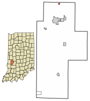
Location of Carbon in Clay County, Indiana.
|
|
| Country | United States |
| State | Indiana |
| County | Clay |
| Township | Van Buren |
| Area | |
| • Total | 0.15 sq mi (0.39 km2) |
| • Land | 0.15 sq mi (0.39 km2) |
| • Water | 0.00 sq mi (0.00 km2) |
| Elevation | 689 ft (210 m) |
| Population
(2020)
|
|
| • Total | 263 |
| • Density | 1,765.10/sq mi (682.31/km2) |
| Time zone | UTC-5 (EST) |
| • Summer (DST) | UTC-5 (EST) |
| ZIP code |
47837
|
| Area code(s) | 812 |
| FIPS code | 18-10198 |
| GNIS feature ID | 0432123 |
Carbon is a small town in Clay County, Indiana, United States. It is located in Van Buren Township. In 2010, about 397 people lived there. Carbon is part of the larger Terre Haute metropolitan area.
Contents
History of Carbon
Carbon began when a railroad was built through the area. A post office opened in Carbon in 1870. The town got its name from the Carbon Coal Company. This company was important in the early days of the town.
Geography of Carbon
Carbon is located in Indiana. Its exact location is 39.598974 degrees North and 87.107510 degrees West. According to the 2010 census, the town covers a total area of about 0.16 square miles (0.41 square kilometers). All of this area is land.
There was once a smaller settlement nearby. It was called South Carbon or Pontiac on old maps. This settlement was on the south edge of Carbon. It was near what is now Poplar Street and County Road 1400 North.
Population in Carbon
| Historical population | |||
|---|---|---|---|
| Census | Pop. | %± | |
| 1880 | 600 | — | |
| 1890 | 521 | −13.2% | |
| 1900 | 951 | 82.5% | |
| 1910 | 493 | −48.2% | |
| 1920 | 572 | 16.0% | |
| 1930 | 476 | −16.8% | |
| 1940 | 510 | 7.1% | |
| 1950 | 480 | −5.9% | |
| 1960 | 409 | −14.8% | |
| 1970 | 344 | −15.9% | |
| 1980 | 307 | −10.8% | |
| 1990 | 350 | 14.0% | |
| 2000 | 334 | −4.6% | |
| 2010 | 397 | 18.9% | |
| 2020 | 263 | −33.8% | |
| U.S. Decennial Census | |||
Carbon's 2010 Census Details
In 2010, the town of Carbon had 397 residents. There were 138 households in total. A household is a group of people living together. Out of these, 98 were families.
The population density was about 2,481 people per square mile. This means many people lived in a small area. There were 165 housing units available.
Most of the people living in Carbon were White, about 96.7%. A small number were from other backgrounds. About 3% of the population identified as Hispanic or Latino.
Many households had children under 18 living with them, about 41.3%. More than half, 55.8%, were married couples. Some households had a single parent. About 29% of households were not families.
The average age in Carbon was 35.6 years old. About 30.7% of residents were under 18. People aged 65 or older made up 9.1% of the population. The town had a nearly equal number of males and females.
See also
 In Spanish: Carbon (Indiana) para niños
 | Kyle Baker |
 | Joseph Yoakum |
 | Laura Wheeler Waring |
 | Henry Ossawa Tanner |

