Cloverland, Indiana facts for kids
Quick facts for kids
Cloverland
|
|
|---|---|

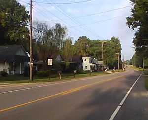
Cloverland, Indiana, along State Road 340
|
|
| Country | United States |
| State | Indiana |
| County | Clay |
| Township | Posey |
| Elevation | 607 ft (185 m) |
| ZIP code |
47834
|
| FIPS code | 18-13888 |
| GNIS feature ID | 432691 |
Cloverland is a small, unincorporated community in Posey Township, Clay County, Indiana. This means it's a group of homes and businesses that isn't officially a town or city with its own government. It is part of the larger Terre Haute area.
Where is Cloverland?
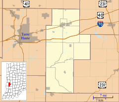
Cloverland is located at 39°30′05″N 87°13′53″W / 39.50139°N 87.23139°W. It's about six miles west of Brazil, which is the main town in Clay County. It's also less than a mile east of the border between Vigo and Clay counties. The land around Cloverland is gently rolling, with small hills and a little stream. The climate here is called a humid continental climate. This means it has warm, humid summers and cold winters.
The Story of Cloverland
Cloverland was first planned in 1834 by a doctor named Charles Modesitt from Terre Haute. He hoped it would grow into a busy town. The community did grow steadily for a while. It had several general stores, a carpentry shop, and other businesses.
However, when the railroad was built, business activity shifted to nearby Brazil. Because of this, Cloverland's population slowly became smaller. A post office was opened in Cloverland in 1850. It stayed open for many years until it closed in 1920. Today, you can still find a church, a commercial building, and a group of houses that remain in Cloverland.
 | Ernest Everett Just |
 | Mary Jackson |
 | Emmett Chappelle |
 | Marie Maynard Daly |


