Saline City, Indiana facts for kids
Quick facts for kids
Saline City
|
|
|---|---|
 |
|
| Country | United States |
| State | Indiana |
| County | Clay |
| Township | Sugar Ridge |
| Elevation | 571 ft (174 m) |
| ZIP code |
47840
|
| FIPS code | 18-67518 |
| GNIS feature ID | 442932 |
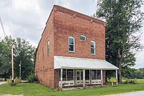
Saline City is a small place in Indiana, United States. It's called an unincorporated community. This means it's a group of homes and businesses that isn't officially a city or town with its own local government.
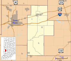
Saline City is located in Sugar Ridge Township, which is part of Clay County. It's also considered part of the larger Terre Haute metropolitan area, a region around the city of Terre Haute.
Contents
History of Saline City
Saline City began to grow because of the railroad. When train tracks were built through this area, it helped the community get started.
Early Services and Growth
A post office was opened in Saline City in 1872. This was an important service for people living there, allowing them to send and receive mail. The post office served the community for many years.
However, the post office eventually closed down in 1951. The name "Saline" likely comes from a "mineral lick." This is a place where animals go to lick salt and other important minerals from the ground.
Geography of Saline City
Saline City is located in the western part of Indiana. Its exact location can be described using geographic coordinates.
Understanding Location Coordinates
The coordinates for Saline City are 39°21′55″N 87°07′56″W / 39.36528°N 87.13222°W. This means it is at 39 degrees, 21 minutes, 55 seconds North latitude and 87 degrees, 7 minutes, 56 seconds West longitude. These numbers help pinpoint its spot on a map of the world.
 | Kyle Baker |
 | Joseph Yoakum |
 | Laura Wheeler Waring |
 | Henry Ossawa Tanner |


