Perth, Indiana facts for kids
Quick facts for kids
Perth
|
|
|---|---|
| Country | United States |
| State | Indiana |
| County | Clay |
| Township | Dick Johnson |
| Elevation | 630 ft (190 m) |
| ZIP code |
47837
|
| FIPS code | 18-59310 |
| GNIS feature ID | 441045 |
Perth is a small, unincorporated community located in Clay County, Indiana, in the United States. An unincorporated community means it's a place where people live, but it doesn't have its own local government like a city or town. Instead, it's usually managed by the county. Perth is also part of the larger Terre Haute metropolitan area, which is a region that includes the city of Terre Haute and its surrounding communities.
Where is Perth Located?
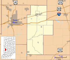
Perth is found in Dick Johnson Township, within Clay County. You can find its exact spot on a map using these coordinates: 39°35′35″N 87°09′43″W / 39.59306°N 87.16194°W. This location is about 630 feet (192 meters) above sea level.
A Look Back: Perth's History
Perth began to grow around the year 1870. This was when a new railroad line was built through the area. Railroads were very important back then for travel and moving goods. They often led to new communities forming along their routes.
The community was given its name after Perth, Scotland. It's interesting to note that it was named for the city in Scotland, not the one in Western Australia.
A post office was opened in Perth in 1880. Post offices were vital for people to send and receive letters and packages. This post office served the community for many years until it closed down in 1929.
 | Kyle Baker |
 | Joseph Yoakum |
 | Laura Wheeler Waring |
 | Henry Ossawa Tanner |


