Owen County, Indiana facts for kids
Quick facts for kids
Owen County
|
|
|---|---|

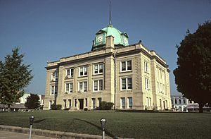
Owen County Courthouse in Spencer, Indiana
|
|

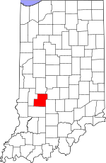
Location within the U.S. state of Indiana
|
|
 Indiana's location within the U.S. |
|
| Country | |
| State | |
| Founded | December 21, 1818 (authorized) 1819 (organized) |
| Named for | Abraham Owen |
| Seat | Spencer |
| Largest town | Spencer |
| Area | |
| • Total | 387.82 sq mi (1,004.4 km2) |
| • Land | 385.29 sq mi (997.9 km2) |
| • Water | 2.54 sq mi (6.6 km2) 0.65%% |
| Population
(2020)
|
|
| • Total | 21,321 |
| • Density | 54.9765/sq mi (21.2266/km2) |
| Time zone | UTC−5 (Eastern) |
| • Summer (DST) | UTC−4 (EDT) |
| Congressional district | 8th |
| Website | Owen County Official Website: http://owencounty.in.gov/ |
| Indiana county number 60 | |
Owen County is a place in the state of Indiana, USA. It's known as a county, which is like a smaller area within a state. In 1920, Owen County was even called the "center of population" for the whole United States! This means that if you imagined all the people in the country balancing on a map, Owen County would be the spot where it would balance.
As of 2020, about 21,321 people live there. The main town and county seat (where the county government is) is Spencer. Owen County is also part of the larger Bloomington area.
Contents
History of Owen County
How Owen County Was Formed
Back in 1787, the new United States created the Northwest Territory. This huge area included what is now Indiana. Later, in 1800, a part of it became the Indiana Territory. William Henry Harrison was chosen as its first governor.
Over time, the Indiana Territory became smaller. By December 1816, it officially became the state of Indiana. Before this, the land belonged to Native American tribes. The U.S. government bought much of this land through treaties in 1809 and 1818. This included the land that would become Owen County. White settlers started moving into the area around 1816.
Owen County was officially created on December 21, 1818. It was made from parts of other counties, Daviess and Sullivan. The county was named after Abraham Owen. He was a brave colonel in the U.S. Army who died in a battle in 1811.
Early Government and Growth
The county's government started in 1819. In 1820, the leaders chose Spencer as the county seat. Spencer was already the biggest settlement in the area.
In 1920, Owen County gained national attention. The U.S. Census Bureau announced that the "Center of Population" for the entire country was in Owen County. This spot was about 8 miles southeast of Spencer. It showed how the population was spreading across the United States.
Geography of Owen County
Land and Water Features
Owen County used to be completely covered in trees. Today, it still has many forests. But some areas have been cleared for farms and towns. The highest point in the county is about 934 feet above sea level. This spot is south of a town called Quincy.
The White River flows through the lower middle part of the county. It enters from Monroe County and then continues into Greene County.
Owen County covers about 387.82 square miles. Most of this (about 385.29 square miles) is land. The rest (about 2.54 square miles) is water.
Neighboring Counties
Owen County shares its borders with several other counties:
- Putnam County - to the north
- Morgan County - to the northeast
- Monroe County - to the southeast
- Greene County - to the south
- Clay County - to the west
Main Roads and Highways
Several important roads run through Owen County:
Parks and Forests
Owen County is home to some beautiful natural areas:
- Cataract Falls State Recreation Area
- McCormick's Creek State Park - This was Indiana's very first state park, opened in 1916!
- Owen-Putnam State Forest (part of it)
Towns in Owen County
Smaller Communities
There are many smaller, unincorporated communities in Owen County:
- Adel
- Alaska
- Arney
- Atkinsonville
- Beamer
- Braysville
- Carp
- Cataract
- Coal City
- Cuba
- Cunot
- Daggett
- Denmark
- Devore
- Farmers
- Freedom
- Freeman
- Hancock Corner
- Hickory Corner
- Highets Corner
- Hubbell
- Jordan
- Lewisville
- Marion Mills
- New Hope
- Patricksburg
- Pottersville
- Quincy
- Romona
- Silex
- Smithville
- Southport
- Stockton
- Vandalia
- Vilas
- Wallace Junction (a ghost town)
- Whitehall
County Townships
Owen County is divided into several townships:
- Clay
- Franklin
- Harrison
- Jackson
- Jefferson
- Jennings
- Lafayette
- Marion
- Montgomery
- Morgan
- Taylor
- Washington
- Wayne
Climate and Weather in Owen County
| Weather chart for Spencer, Indiana | |||||||||||||||||||||||||||||||||||||||||||||||
|---|---|---|---|---|---|---|---|---|---|---|---|---|---|---|---|---|---|---|---|---|---|---|---|---|---|---|---|---|---|---|---|---|---|---|---|---|---|---|---|---|---|---|---|---|---|---|---|
| J | F | M | A | M | J | J | A | S | O | N | D | ||||||||||||||||||||||||||||||||||||
|
2.6
34
15
|
2.6
40
19
|
3.7
51
28
|
4.5
62
37
|
5
72
47
|
4.7
81
57
|
4.6
84
61
|
4.5
82
59
|
3.3
76
50
|
3.2
65
38
|
4.1
52
30
|
3.3
40
21
|
||||||||||||||||||||||||||||||||||||
| temperatures in °F precipitation totals in inches source: The Weather Channel |
|||||||||||||||||||||||||||||||||||||||||||||||
|
Metric conversion
|
|||||||||||||||||||||||||||||||||||||||||||||||
The weather in Spencer, Owen County, changes with the seasons. In January, the average low temperature is about 15 degrees Fahrenheit. In July, the average high temperature is around 84 degrees Fahrenheit. The coldest temperature ever recorded was -33 degrees Fahrenheit in January 1994. The hottest was 107 degrees Fahrenheit in July 1954.
The county also gets rain throughout the year. May usually has the most rain, with about 4.97 inches. January typically has the least, with about 2.56 inches.
Population and People
| Historical population | |||
|---|---|---|---|
| Census | Pop. | %± | |
| 1820 | 838 | — | |
| 1830 | 4,017 | 379.4% | |
| 1840 | 8,359 | 108.1% | |
| 1850 | 12,106 | 44.8% | |
| 1860 | 14,376 | 18.8% | |
| 1870 | 16,137 | 12.2% | |
| 1880 | 15,901 | −1.5% | |
| 1890 | 15,040 | −5.4% | |
| 1900 | 15,149 | 0.7% | |
| 1910 | 14,053 | −7.2% | |
| 1920 | 12,760 | −9.2% | |
| 1930 | 11,351 | −11.0% | |
| 1940 | 12,090 | 6.5% | |
| 1950 | 11,763 | −2.7% | |
| 1960 | 11,400 | −3.1% | |
| 1970 | 12,163 | 6.7% | |
| 1980 | 15,841 | 30.2% | |
| 1990 | 17,281 | 9.1% | |
| 2000 | 21,786 | 26.1% | |
| 2010 | 21,575 | −1.0% | |
| 2020 | 21,321 | −1.2% | |
| 2023 (est.) | 21,532 | −0.2% | |
| US Decennial Census 1790-1960 1900-1990 1990-2000 2010 |
|||
Population in 2010
In 2010, there were 21,575 people living in Owen County. They lived in 8,486 homes. Most people in the county were white (97.9%). A small number of people were Asian, American Indian, or Black. About 0.9% of the population was of Hispanic or Latino background.
Many families lived in Owen County. About 31% of homes had children under 18. Most homes (56.1%) were married couples living together. The average age of people in the county was 42.4 years old.
See also
 In Spanish: Condado de Owen (Indiana) para niños
 | Misty Copeland |
 | Raven Wilkinson |
 | Debra Austin |
 | Aesha Ash |

