Morgan County, Indiana facts for kids
Quick facts for kids
Morgan County
|
|
|---|---|

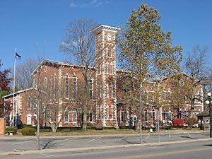
Morgan County courthouse in Martinsville
|
|

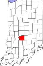
Location within the U.S. state of Indiana
|
|
 Indiana's location within the U.S. |
|
| Country | |
| State | |
| Founded | February 15, 1822 (authorized) December 1822 (organized) |
| Named for | Gen. Daniel Morgan |
| Seat | Martinsville |
| Largest city | Martinsville |
| Area | |
| • Total | 409.43 sq mi (1,060.4 km2) |
| • Land | 403.97 sq mi (1,046.3 km2) |
| • Water | 5.46 sq mi (14.1 km2) 1.33%% |
| Population
(2020)
|
|
| • Total | 71,780 |
| • Density | 180/sq mi (70/km2) |
| Time zone | UTC−5 (Eastern) |
| • Summer (DST) | UTC−4 (EDT) |
| Congressional districts | 4th, 9th |
| Website | http://www.morgancounty.in.gov/ |
| Indiana county number 55 | |
Morgan County is a county in the U.S. state of Indiana. In 2020, about 71,780 people lived there. The main city and county seat is Martinsville.
Morgan County is located between two larger cities: Indianapolis and Bloomington. It's part of the bigger Indianapolis area, which includes Carmel and Anderson. Two important roads, Interstate 69 and Indiana State Road 67, help many people travel to work each day. The county has 14 smaller areas called townships that provide local services.
Contents
History of Morgan County
The area that became Indiana was first set up by a law called the Northwest Ordinance in 1787. At that time, Native American tribes still lived there. In 1818, several agreements were made, which led to the Delaware tribe moving west by 1820. This opened the land for new settlers.
The area was then divided into new counties. Morgan County was officially created on February 15, 1822. It was named after General Daniel Morgan. He was a hero in the American Revolutionary War, known for winning the Battle of Cowpens.
The first settlers arrived in Morgan County in 1822. Many came from southern states. A group of Quakers settled near Mooresville because they were against slavery. A famous resident from Mooresville, Paul Hadley, designed the current Indiana flag. He was also a well-known artist in the early 1900s.
In the late 1800s and early 1900s, Martinsville became famous for its natural mineral springs. People visited spas there for their health. This is why the sports teams at Martinsville High School are called the "Artesians," named after underground water sources.
In the early 2000s, the county government made some big changes. They created new groups to help plan the county's future and boost its economy. They also started the county's first park and recreation board. Morgan County was also the first in the Indianapolis area to ban smoking in restaurants in 2004.
The Courthouse Building
The very first place where Morgan County courts met was in a pioneer's log cabin. In 1823, they started building the first real courthouse, which was a two-story log house. A brick courthouse replaced it in 1833.
The current Morgan County courthouse was designed by Isaac Hodgson. It was built between 1857 and 1859. The building cost $32,000, which was a lot of money back then! It looks very similar to another courthouse Hodgson designed in Jennings County. The Martinsville courthouse was updated in the 1970s. It's made of red brick with white stone and has tall, arched windows. It's one of the few courthouses left that were built before the American Civil War.
Geography and Nature
Morgan County is special because it's where the huge sheets of ice, called glaciers, stopped during the last ice age. This means the county has both flat areas and rolling hills. It even has some of the most varied soil types in the United States!
Most of the thick forests from the 1700s have been cleared in the flat areas. Now, these parts are used for farming or cities. However, the county still has many wooded valleys that lead to the White River, which flows southwest. The land in Morgan County ranges from about 604 feet to 1,010 feet above sea level.
The county covers about 409 square miles. Most of this (about 404 square miles) is land, and a small part (about 5.5 square miles) is water. The White River Valley cuts through Morgan County. People in the county are working to protect the river. They are creating parks and green spaces along it and hold a yearly river cleanup day.
Because of the river valley and the hills that weren't covered by glaciers, Morgan County has a unique landscape compared to the rest of the Indianapolis area. People who live here are proud of the beautiful scenery. They have created a county park system and plans for bike and walking trails to help everyone enjoy these natural spots. There's even a yearly 5-mile run to raise money for these trails.
Neighboring Counties
- Hendricks County (north)
- Marion County (northeast)
- Johnson County (east)
- Brown County (southeast)
- Monroe County (south)
- Owen County (southwest)
- Putnam County (northwest)
Main Roads
Towns and Communities
Cities and Towns
- Bethany
- Brooklyn
- Martinsville (city/county seat)
- Monrovia
- Mooresville
- Morgantown
- Paragon
Smaller Unincorporated Places
- Adams
- Alaska
- Allman
- Banta
- Beech Grove
- Bluffs
- Briarwood
- Brookmoor
- Bunker Hill
- Camby (part)
- Center Valley
- Centerton
- Champlin Meadows
- Chetwynd
- Cope
- Crestview Heights
- Crown Center
- Eminence
- Exchange
- Fields
- Five Points
- Gasburg
- Hall
- Hyndsdale
- Lake Hart
- Landersdale
- Lewisville
- Little Point
- Mahalasville
- Maxwell
- McDaniel
- Miller
- Mount Zion Corner
- Painted Hills (census-designated place)
- Plano
- Ridgewood
- Shelburne
- Stines Mill Corner
- Turkey Track
- Wakeland
- Waverly
- Waverly Woods
- Whitaker
- Wilbur
- Willowbrook Estates
- Wiser
- Woodcrest
- Wolff
- Young
Townships
- Adams
- Ashland
- Baker
- Brown
- Clay
- Green
- Gregg
- Harrison
- Jackson
- Jefferson
- Madison
- Monroe
- Ray
- Washington
Climate and Weather
| Weather chart for Martinsville, Indiana | |||||||||||||||||||||||||||||||||||||||||||||||
|---|---|---|---|---|---|---|---|---|---|---|---|---|---|---|---|---|---|---|---|---|---|---|---|---|---|---|---|---|---|---|---|---|---|---|---|---|---|---|---|---|---|---|---|---|---|---|---|
| J | F | M | A | M | J | J | A | S | O | N | D | ||||||||||||||||||||||||||||||||||||
|
3.1
36
21
|
2.4
41
24
|
3.7
52
33
|
4.3
64
43
|
4.8
74
54
|
5
82
63
|
4.4
86
66
|
3.2
84
65
|
3.1
78
57
|
3.2
66
46
|
3.5
53
35
|
2.9
40
26
|
||||||||||||||||||||||||||||||||||||
| temperatures in °F precipitation totals in inches source: The Weather Channel |
|||||||||||||||||||||||||||||||||||||||||||||||
|
Metric conversion
|
|||||||||||||||||||||||||||||||||||||||||||||||
In Martinsville, the average temperature in January is about 18°F (coldest). In July, it's about 85°F (warmest). The lowest temperature ever recorded was -35°F in January 1994, and the highest was 105°F in July 1954. The county usually gets the most rain in May and the least in February.
Population Information
| Historical population | |||
|---|---|---|---|
| Census | Pop. | %± | |
| 1830 | 5,593 | — | |
| 1840 | 10,741 | 92.0% | |
| 1850 | 14,576 | 35.7% | |
| 1860 | 16,110 | 10.5% | |
| 1870 | 17,528 | 8.8% | |
| 1880 | 18,900 | 7.8% | |
| 1890 | 18,643 | −1.4% | |
| 1900 | 20,457 | 9.7% | |
| 1910 | 21,182 | 3.5% | |
| 1920 | 20,010 | −5.5% | |
| 1930 | 19,424 | −2.9% | |
| 1940 | 19,801 | 1.9% | |
| 1950 | 23,726 | 19.8% | |
| 1960 | 33,875 | 42.8% | |
| 1970 | 44,176 | 30.4% | |
| 1980 | 51,999 | 17.7% | |
| 1990 | 55,920 | 7.5% | |
| 2000 | 66,689 | 19.3% | |
| 2010 | 68,894 | 3.3% | |
| 2020 | 71,780 | 4.2% | |
| 2023 (est.) | 73,227 | 6.3% | |
| US Decennial Census 1790-1960 1900-1990 1990-2000 2010 |
|||
What the 2010 Census Showed
In 2010, Morgan County had 68,894 people living in 25,765 households. Most people (97.7%) were white. Smaller groups included Asian (0.4%), American Indian (0.3%), and Black or African American (0.3%). About 1.2% of the population was of Hispanic or Latino background.
Many people in Morgan County have English roots (46%), German roots (22.1%), or Irish roots (10.3%).
About 35.8% of households had children under 18. Most households (59.8%) were married couples. The average age in the county was 39.9 years old.
The average income for a household in the county was about $47,697. For families, it was about $62,507. About 10.1% of all people in the county lived below the poverty line. This included 14.9% of those under 18 and 6.8% of those aged 65 or older.
Education
Morgan County has a public library system with six different branches for people to use.
See also
 In Spanish: Condado de Morgan (Indiana) para niños
 | William M. Jackson |
 | Juan E. Gilbert |
 | Neil deGrasse Tyson |


