Hendricks County, Indiana facts for kids
Quick facts for kids
Hendricks County
|
|
|---|---|

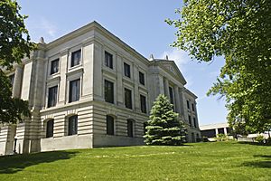
Hendricks County courthouse in Danville
|
|

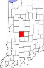
Location within the U.S. state of Indiana
|
|
 Indiana's location within the U.S. |
|
| Country | |
| State | |
| Founded | December 20, 1823 (created) Summer 1824 (organized) |
| Named for | William Hendricks |
| Seat | Danville |
| Largest town | Plainfield |
| Area | |
| • Total | 408.78 sq mi (1,058.7 km2) |
| • Land | 406.91 sq mi (1,053.9 km2) |
| • Water | 1.87 sq mi (4.8 km2) 0.46%% |
| Population
(2020)
|
|
| • Total | 174,788 |
| • Density | 427.585/sq mi (165.0913/km2) |
| Time zone | UTC−5 (Eastern) |
| • Summer (DST) | UTC−4 (EDT) |
| Congressional district | 4th |
| Indiana county number 32 | |
Hendricks County is a county in the U.S. state of Indiana. In 2020, about 174,788 people lived here. The main town and county seat is Danville.
Hendricks County is the third largest county in the Indianapolis area. It is also one of the fastest-growing counties in Indiana.
Contents
History of Hendricks County
After the American Revolutionary War, the United States gained control of the land that is now Indiana. In 1787, this area became part of the Northwest Territory. Later, in 1800, it was named the Indiana Territory.
Indiana became a state in December 1816. However, some land was still claimed by Native American tribes. The land where Hendricks County is located became part of the United States in 1818. This was after a special agreement called the Treaty of St. Mary's. People called this new land the "New Purchase."
How Hendricks County Was Formed
In December 1823, Indiana's government met in Corydon. They decided to create three new counties. Hendricks County was one of them. It became the 51st county in Indiana.
The law to create Hendricks County was signed on December 20, 1823. It was signed by Indiana Governor William Hendricks. The county was named in his honor. Before the county government was set up, nearby counties helped manage the area.
Early Settlers and Danville
After the 1818 treaty, the government surveyed the land. This meant they measured and mapped it. Settlers began moving into the area around 1820. By 1823, enough people lived there to form a county.
In July 1824, officials chose Danville as the county seat. A county seat is the main town where the county government is located. The town's plan was officially recorded in October 1824. A courthouse was built in Danville and was ready by 1826.
Geography of Hendricks County
Hendricks County has gently rolling hills. Most of the land is used for farming or towns. Two creeks, the West Fork and East Fork of White Lick Creek, flow through the county. They meet near the southern border. The highest point in the county is about 1,030 feet (314 meters) above sea level. It is located west of Danville.
The county covers about 408.78 square miles (1,058.7 square kilometers). Most of this area, about 406.91 square miles (1,053.9 square kilometers), is land. Only a small part, about 1.87 square miles (4.8 square kilometers), is water.
Neighboring Counties
- Boone County - north
- Marion County - east
- Morgan County - south
- Putnam County - west
- Montgomery County - northwest
Towns in Hendricks County
- Amo
- Avon
- Brownsburg
- Clayton
- Coatesville
- Danville - county seat
- Lizton
- North Salem
- Pittsboro
- Plainfield
- Stilesville
Unincorporated Communities
These are smaller communities that are not officially towns.
- Belleville
- Camby - part
- Cartersburg
- Clermont Heights
- Friendswood
- Gale
- Hadley
- Hazelwood
- Joppa
- Maplewood
- Montclair
- New Winchester
- Pecksburg
- Raintown
- Reno
- Six Points
- Springtown
- Summit
- Tilden
- Center Valley
Townships
Counties in Indiana are divided into smaller areas called townships.
- Brown
- Center
- Clay
- Eel River
- Franklin
- Guilford
- Liberty
- Lincoln
- Marion
- Middle
- Union
- Washington
Climate in Hendricks County
| Weather chart for Danville, Indiana | |||||||||||||||||||||||||||||||||||||||||||||||
|---|---|---|---|---|---|---|---|---|---|---|---|---|---|---|---|---|---|---|---|---|---|---|---|---|---|---|---|---|---|---|---|---|---|---|---|---|---|---|---|---|---|---|---|---|---|---|---|
| J | F | M | A | M | J | J | A | S | O | N | D | ||||||||||||||||||||||||||||||||||||
|
2.5
34
18
|
2.4
40
23
|
3.4
51
32
|
3.6
63
41
|
4.4
74
52
|
4.1
82
61
|
4.4
86
65
|
3.8
84
63
|
2.9
77
55
|
2.8
66
44
|
3.6
52
34
|
3
39
24
|
||||||||||||||||||||||||||||||||||||
| temperatures in °F precipitation totals in inches source: The Weather Channel |
|||||||||||||||||||||||||||||||||||||||||||||||
|
Metric conversion
|
|||||||||||||||||||||||||||||||||||||||||||||||
In Danville, the average temperature in January is about 18°F (minus 8°C). In July, the average high is about 86°F (30°C). The lowest temperature ever recorded was minus 27°F (minus 33°C) in January 1994. The highest was 106°F (41°C) in July 1936.
The amount of rain and snow changes throughout the year. February usually gets about 2.41 inches (6.1 cm) of precipitation. July gets the most, with about 4.42 inches (11.2 cm).
Transportation
Airport
- 2R2 - Hendricks County Airport
Major Highways
Many important roads pass through Hendricks County.
 I-65
I-65 I-70
I-70 I-74
I-74 US 36
US 36 US 40
US 40 US 136
 SR 39
SR 39 SR 67
SR 67 SR 75
SR 75 SR 234
 SR 236
 SR 267
Public Transit
- Central Indiana Regional Transportation Authority
Population and People
| Historical population | |||
|---|---|---|---|
| Census | Pop. | %± | |
| 1830 | 3,975 | — | |
| 1840 | 11,264 | 183.4% | |
| 1850 | 14,083 | 25.0% | |
| 1860 | 16,953 | 20.4% | |
| 1870 | 20,277 | 19.6% | |
| 1880 | 22,981 | 13.3% | |
| 1890 | 21,498 | −6.5% | |
| 1900 | 21,292 | −1.0% | |
| 1910 | 20,840 | −2.1% | |
| 1920 | 20,291 | −2.6% | |
| 1930 | 19,725 | −2.8% | |
| 1940 | 20,151 | 2.2% | |
| 1950 | 24,594 | 22.0% | |
| 1960 | 40,896 | 66.3% | |
| 1970 | 53,974 | 32.0% | |
| 1980 | 69,804 | 29.3% | |
| 1990 | 75,717 | 8.5% | |
| 2000 | 104,093 | 37.5% | |
| 2010 | 145,448 | 39.7% | |
| 2020 | 174,788 | 20.2% | |
| 2023 (est.) | 186,387 | 28.1% | |
| US Decennial Census 1790-1960 1900-1990 1990-2000 2010 |
|||
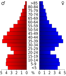
In 2010, there were 145,448 people living in Hendricks County. There were 52,368 households, which are groups of people living together. The average number of people in a household was 2.71.
Most people in the county were white (90.1%). Other groups included Black or African American (4.9%) and Asian (2.1%). About 3.0% of the population was of Hispanic or Latino origin.
The average age of people in the county was 36.7 years old. About 40.3% of households had children under 18 living with them. The median income for a household was $47,697. This means half of the households earned more and half earned less than this amount.
See also
 In Spanish: Condado de Hendricks para niños
 | Toni Morrison |
 | Barack Obama |
 | Martin Luther King Jr. |
 | Ralph Bunche |


