Putnam County, Indiana facts for kids
Quick facts for kids
Putnam County
|
|
|---|---|

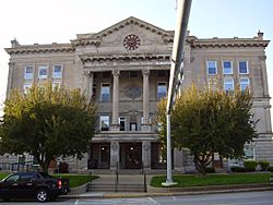
Putnam County Courthouse in Greencastle
|
|

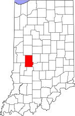
Location within the U.S. state of Indiana
|
|
 Indiana's location within the U.S. |
|
| Country | |
| State | |
| Founded | December 31, 1821 (created) April 1822 (organized) |
| Named for | Israel Putnam |
| Seat | Greencastle |
| Largest city | Greencastle |
| Area | |
| • Total | 482.69 sq mi (1,250.2 km2) |
| • Land | 480.53 sq mi (1,244.6 km2) |
| • Water | 2.16 sq mi (5.6 km2) 0.45%% |
| Population
(2020)
|
|
| • Total | 36,726 |
| • Density | 76.0861/sq mi (29.3770/km2) |
| Time zone | UTC−5 (Eastern) |
| • Summer (DST) | UTC−4 (EDT) |
| Congressional district | 4th |
| Indiana county number 67 | |
Putnam County is a place called a county in the state of Indiana. In 2020, about 36,726 people lived here. The main town, or county seat, is Greencastle.
The county got its name from Israel Putnam. He was a brave soldier in the French and Indian War. He also became a general in the American Revolutionary War. Putnam County was officially started in 1821 and began operating in April 1822.
Contents
History of Putnam County
After the American Revolutionary War, the United States gained control of the land that is now Indiana. In 1787, this area became part of the Northwest Territory. Later, in 1800, the Indiana Territory was formed. William Henry Harrison was chosen as its first governor.
Indiana became a state in 1816. However, some land was still claimed by Native American tribes. The land where Putnam County is today became part of the United States in 1818. This happened through a special agreement called the Treaty of St. Mary's.
How Putnam County Was Formed
The first county in this area was Knox County, created in 1790. Over time, as more people moved in, smaller counties were made. In 1821, the Indiana government decided to create a new county. This new county would be Putnam County.
Five people were chosen to pick a main town for the county. They met in a log cabin in 1822. This cabin belonged to James Athey. Even though they met, they didn't choose a county seat that year.
In 1823, a new group of people was chosen. They successfully picked Greencastle as the county seat. It was right in the middle of the county. A family named Dukes even gave 70 acres of land for the new town. The county's borders changed a little in 1825 when Clay County was created. Since then, Putnam County's shape has stayed the same.
Geography and Nature
The northern part of Putnam County is mostly flat. As you go south, you'll see more rolling hills. Long ago, the county was completely covered in trees. Now, the flat areas are used for farming. The areas near rivers and streams are still wooded.
Walnut Creek flows through the eastern part of the county. Big Walnut Creek flows through the upper part. It eventually reaches Cecil M. Harden Lake. The highest point in the county is about 980 feet above sea level. It's near Bainbridge.
People started digging for limestone here in the 1800s. A large amount of iron ore was also found near Cloverdale in the 1860s.
Putnam County covers about 482.69 square miles. Most of this (about 480.53 square miles) is land. The rest (about 2.16 square miles) is water.
Neighboring Counties
- Montgomery County – north
- Hendricks County – east
- Morgan County – southeast
- Owen County – south
- Clay County – southwest
- Parke County – west
Lakes in Putnam County
- Cagles Mill Lake (part)
- Glenn Flint Lake
- Heritage Lake
Protected Natural Areas
- DePauw University Nature Park
- Fern Cliff Nature Preserve
- Lieber State Recreation Area
Cities and Towns
- Greencastle (the county seat)
Other Communities
- Heritage Lake
- Van Bibber Lake
- Barnard
- Belle Union
- Blakesburg
- Brick Chapel
- Broad Park
- Brunerstown
- Cagle Mill
- Carpentersville
- Cary
- Clinton Falls
- Cradick Corner
- Edgewood Lake
- Fincastle
- Fox Ridge
- Groveland
- Hirt Corner
- Jenkinsville
- Keytsville
- Limedale
- Manhattan
- Morton
- Mount Meridian
- New Maysville
- Pleasant Gardens
- Portland Mills
- Putnamville
- Raab Crossroads
- Raccoon
- Reelsville
- Vivalia
- Westland
Townships in Putnam County
- Clinton
- Cloverdale
- Floyd
- Franklin
- Greencastle
- Jackson
- Jefferson
- Madison
- Marion
- Monroe
- Russell
- Warren
- Washington
Main Roads and Highways
 Interstate 70
 U.S. Route 36
 U.S. Route 40
 U.S. Route 231
 Indiana State Road 42
 Indiana State Road 75
 Indiana State Road 236
 Indiana State Road 240
 Indiana State Road 243
Climate and Weather
| Weather chart for Greencastle, Indiana | |||||||||||||||||||||||||||||||||||||||||||||||
|---|---|---|---|---|---|---|---|---|---|---|---|---|---|---|---|---|---|---|---|---|---|---|---|---|---|---|---|---|---|---|---|---|---|---|---|---|---|---|---|---|---|---|---|---|---|---|---|
| J | F | M | A | M | J | J | A | S | O | N | D | ||||||||||||||||||||||||||||||||||||
|
2.4
34
18
|
2.5
40
22
|
3.6
51
32
|
3.8
63
42
|
4.8
74
52
|
4.3
82
61
|
5.1
86
65
|
4.2
84
63
|
3.3
78
56
|
3.1
66
44
|
4
52
34
|
3.1
39
23
|
||||||||||||||||||||||||||||||||||||
| temperatures in °F precipitation totals in inches source: The Weather Channel |
|||||||||||||||||||||||||||||||||||||||||||||||
|
Metric conversion
|
|||||||||||||||||||||||||||||||||||||||||||||||
In Greencastle, the average temperature in January is about 18°F. In July, it's around 86°F. The coldest temperature ever recorded was -23°F in January 1985. The hottest was 107°F in July 1954.
The amount of rain and snow changes throughout the year. January usually gets about 2.40 inches of precipitation. July gets the most, with about 5.14 inches.
Population and People
| Historical population | |||
|---|---|---|---|
| Census | Pop. | %± | |
| 1830 | 8,262 | — | |
| 1840 | 16,843 | 103.9% | |
| 1850 | 18,615 | 10.5% | |
| 1860 | 20,681 | 11.1% | |
| 1870 | 21,514 | 4.0% | |
| 1880 | 22,501 | 4.6% | |
| 1890 | 22,335 | −0.7% | |
| 1900 | 21,478 | −3.8% | |
| 1910 | 20,520 | −4.5% | |
| 1920 | 19,880 | −3.1% | |
| 1930 | 20,448 | 2.9% | |
| 1940 | 20,839 | 1.9% | |
| 1950 | 22,950 | 10.1% | |
| 1960 | 24,927 | 8.6% | |
| 1970 | 26,932 | 8.0% | |
| 1980 | 29,163 | 8.3% | |
| 1990 | 30,315 | 4.0% | |
| 2000 | 36,019 | 18.8% | |
| 2010 | 37,963 | 5.4% | |
| 2020 | 36,726 | −3.3% | |
| 2023 (est.) | 37,567 | −1.0% | |
| US Decennial Census 1790-1960 1900-1990 1990-2000 2010 |
|||
In 2010, there were 37,963 people living in Putnam County. These people lived in 12,917 homes. About 9,256 of these were families. Most people (93.4%) were white. About 4.0% were black or African American.
About 32.9% of homes had children under 18 living there. The average age of people in the county was 37.9 years old.
Fun Places to Visit
Big Walnut Sports Park
Big Walnut Sports Park is a large park in Greencastle. It started with volunteers in 1988. In 2014, the park became part of the city. It has fields for baseball, softball, and soccer. You can also find a walking trail, picnic tables, and a Frisbee golf course. There's even a new dog park!
Cagles Mill Lake
Cagles Mill Lake was built in 1952. It was Indiana's first lake made to control floods. It helps protect the Eel and White rivers. The lake is 1,400 acres big. You can find Cataract Falls here, which is fed by Mill Creek. Long ago, Native American tribes like the Miami and Shawnee lived in this area.
DePauw University Nature Park
The DePauw Nature Park is a great place for hiking. It has a 9-mile loop trail. You can see a lake, wildlife, and many birds. The trails are open all year. This area used to be a limestone quarry from 1917 to 1977. Later, the company gave 280 acres of land to DePauw University. They also leased more land for a very low price. Now, the park is 520 acres big and open to everyone.
Fern Cliff Nature Preserve
Fern Cliff is known for its beautiful sandstone cliffs. It has deep, wooded areas and many ferns. It's a popular spot for hiking, taking pictures, and watching birds. The trails can be a bit challenging.
Glenn Flint Lake
Glenn Flint Lake is north of Greencastle. It's a 371-acre lake with many fish. In 1995, they worked to improve the lake. Now, fish like bluegills and crappies are doing very well. The state's Division of Fish and Wildlife helps manage the fishing here.
Greencastle People Pathways
People Pathways is a group that plans walking and biking trails. These paths connect different public places in Greencastle. You can use them to get to schools, parks, and libraries. The paths are being built in different stages.
Lincoln Park Speedway
Lincoln Park Speedway is in Putnamville. It's a place where you can watch exciting car races. They have different types of race cars, like Sprint Cars and Modifieds. Races happen on Saturday nights.
Putnam Park Road Course
The Putnam Park Road Course is a special track for racing cars. It's 1.78 miles long and has 10 turns. It opened in 1992. The track is used for car clubs and professional teams to test their vehicles.
Putnam County Playhouse
The Putnam County Playhouse started in 1961. Its goal is to let people in the area enjoy live theater. For many years, plays were performed in different places. In 1983, they turned an old barn into a theater. This barn was built in 1918. The new theater, called the Hazel Day Longden Barn Theatre, opened on June 4, 1983.
Over the years, the theater has been improved. They added a new workshop and costume area. They also added a cooling system and replaced the seats. Now, the theater has 198 seats. The Playhouse performs two musicals and two plays each year from June to September. Every other year, they also put on a play for children.
Education
Putnam County has several school districts:
- Cloverdale Community Schools
- Greencastle Community School Corporation
- North Putnam Community Schools
- South Putnam Community Schools
Greencastle High School is part of the Greencastle district.
Covered Bridges
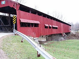
Putnam County is home to several beautiful covered bridges.
- The Dick Huffman or Webster Covered Bridge is the furthest south.
- Houck Covered Bridge is south of Greencastle. The Oakala Covered Bridge is also nearby.
- Edna Collins Covered Bridge is said to be haunted!
- Dunbar Covered Bridge is closest to Greencastle. You can reach it from US 231 north.
- Baker's Camp Covered Bridge is east of Bainbridge on old US 36.
- Rolling Stone Covered Bridge is north of US 36.
- Rolling Stone #2 is another covered bridge, further north on gravel roads.
- Pine Bluff Covered Bridge is also on a gravel road.
- Cornstalk Covered Bridge is the furthest north. It's east of Raccoon near US 231.
Athletics
Putnam County has many sports teams and activities:
- Indiana Smoke Softball (based in Coatesville)
- Indiana Smoke Baseball
- Putnam County Swim Team (based in Greencastle)
- Sports at the Big Walnut Sports Park in east Greencastle.
See also
 In Spanish: Condado de Putnam (Indiana) para niños
 | Selma Burke |
 | Pauline Powell Burns |
 | Frederick J. Brown |
 | Robert Blackburn |


