Cloverdale, Indiana facts for kids
Quick facts for kids
Cloverdale, Indiana
|
|
|---|---|
 |
|

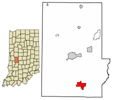
Location of Cloverdale in Putnam County, Indiana.
|
|
| Country | United States |
| State | Indiana |
| County | Putnam |
| Township | Cloverdale, Warren |
| Area | |
| • Total | 3.55 sq mi (9.20 km2) |
| • Land | 3.49 sq mi (9.03 km2) |
| • Water | 0.06 sq mi (0.17 km2) |
| Elevation | 787 ft (240 m) |
| Population
(2020)
|
|
| • Total | 2,060 |
| • Density | 590.60/sq mi (228.03/km2) |
| Time zone | UTC-5 (EST) |
| • Summer (DST) | UTC-4 (EDT) |
| ZIP code |
46120
|
| Area code(s) | 765 |
| FIPS code | 18-13852 |
| GNIS feature ID | 2396656 |
| Website | https://www.cloverdalein.com/home.html |
Cloverdale is a town in Putnam County, in the U.S. state of Indiana. It is part of Cloverdale and Warren townships. In 2020, about 2,060 people lived there.
Contents
History of Cloverdale
Cloverdale was officially started in 1839. The town got its name because there were many clover plants and small valleys, called dales, nearby. A post office has been open in Cloverdale since 1836. This means people could send and receive mail there even before the town was formally planned.
Geography of Cloverdale
Cloverdale covers a total area of about 3.52 square miles (9.12 square kilometers). Most of this area, about 3.46 square miles (8.96 square kilometers), is land. The rest, about 0.06 square miles (0.16 square kilometers), is water. This means the town is mostly land with a small amount of water, like ponds or small streams.
Population and People
The number of people living in Cloverdale has changed over the years. This information comes from the U.S. Decennial Census, which counts everyone in the country every ten years.
| Historical population | |||
|---|---|---|---|
| Census | Pop. | %± | |
| 1850 | 148 | — | |
| 1860 | 318 | 114.9% | |
| 1870 | 317 | −0.3% | |
| 1880 | 477 | 50.5% | |
| 1890 | 437 | −8.4% | |
| 1900 | 445 | 1.8% | |
| 1910 | 624 | 40.2% | |
| 1920 | 678 | 8.7% | |
| 1930 | 627 | −7.5% | |
| 1940 | 657 | 4.8% | |
| 1950 | 649 | −1.2% | |
| 1960 | 741 | 14.2% | |
| 1970 | 870 | 17.4% | |
| 1980 | 1,357 | 56.0% | |
| 1990 | 1,681 | 23.9% | |
| 2000 | 2,243 | 33.4% | |
| 2010 | 2,172 | −3.2% | |
| 2020 | 2,060 | −5.2% | |
| U.S. Decennial Census | |||
2010 Census Details
In 2010, the census showed that 2,172 people lived in Cloverdale. There were 885 households, which means 885 different homes or groups of people living together. Out of these, 608 were families.
The town had about 628 people per square mile (242 people per square kilometer). Most of the people living in Cloverdale were White (97.4%). A small number were African American (0.6%), Native American (0.3%), or Asian (0.3%). Some people were from other backgrounds or more than one race. About 0.9% of the population was Hispanic or Latino.
Many households (32.1%) had children under 18 living with them. About half (50.5%) were married couples. Some households had a single parent, either a mother (12.5%) or a father (5.6%). About 27.5% of homes had just one person living there.
The average age of people in Cloverdale was 42.2 years old. About 22.8% of residents were under 18. About 16.5% were 65 years old or older. The town had slightly more females (51.7%) than males (48.3%).
Town Services
Cloverdale has its own local communication company called Endeavor Communications. This company used to be known as Clay County Rural Telephone Cooperative. It provides phone and internet services to over 10,000 customers. Another local company, PDS Wireless, also offers internet service in Cloverdale and nearby areas.
See also
 In Spanish: Cloverdale (Indiana) para niños
 | Jessica Watkins |
 | Robert Henry Lawrence Jr. |
 | Mae Jemison |
 | Sian Proctor |
 | Guion Bluford |


