Danville, Indiana facts for kids
Quick facts for kids
Danville, Indiana
|
|||
|---|---|---|---|
|
Town
|
|||

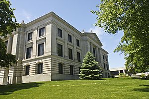
Hendricks County Courthouse in Danville
|
|||
|
|||
| Motto(s):
"A Great Place to Spend an Hour or a Lifetime"
|
|||

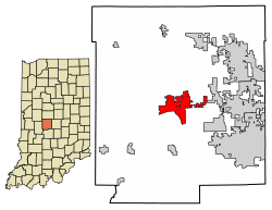
Location of Danville in Hendricks County, Indiana
|
|||
| Country | United States | ||
| State | Indiana | ||
| County | Hendricks | ||
| Township | Center | ||
| Area | |||
| • Total | 8.80 sq mi (22.80 km2) | ||
| • Land | 8.75 sq mi (22.67 km2) | ||
| • Water | 0.05 sq mi (0.13 km2) | ||
| Elevation | 879 ft (268 m) | ||
| Population
(2020)
|
|||
| • Total | 10,559 | ||
| • Density | 1,206.47/sq mi (465.83/km2) | ||
| Time zone | UTC-5 (EST) | ||
| • Summer (DST) | UTC-4 (EDT) | ||
| ZIP code |
46122
|
||
| Area code(s) | 317 | ||
| FIPS code | 18-16804 | ||
| GNIS feature ID | 2396678 | ||
Danville is a town located in Hendricks County, Indiana, United States. It is the main town, also known as the county seat, of Hendricks County. In 2020, about 10,559 people lived there.
Contents
History of Danville
Danville was started in 1824. Just one year later, it got its own post office. The town officially became an incorporated town in 1835.
Several buildings and areas in Danville are very old and important. They are listed on the National Register of Historic Places. This means they are special places that are protected because of their history. Some of these include:
- The Ora Adams House
- The Leander Campbell House
- The Danville Courthouse Square Historic District
- The Danville Main Street Historic District
- The Dr. Jeremiah and Ann Jane DePew House
- The Hendricks County Jail and Sheriff's Residence
- The Twin Bridges
- The Wilson-Courtney House
Geography of Danville
Danville is right in the middle of Hendricks County. A main road called U.S. Route 36 runs through the town. This road is also known as Main Street. If you go east on U.S. Route 36, you'll reach Indianapolis. Going west leads to Decatur, Illinois.
Another important road, Indiana State Road 39, also passes through Danville. It goes north to Lizton and Interstate 74. To the south, it leads to Center Valley and Interstate 70.
Danville covers about 8.8 square miles (22.8 square kilometers). Most of this area is land. A small part is water, like the West Fork of White Lick Creek. This creek flows through the eastern part of town. It eventually joins the White River.
Airport in Danville
- 2R2 – Hendricks County Airport is located near Danville.
People of Danville (Demographics)
| Historical population | |||
|---|---|---|---|
| Census | Pop. | %± | |
| 1850 | 386 | — | |
| 1860 | 895 | 131.9% | |
| 1870 | 1,040 | 16.2% | |
| 1880 | 1,598 | 53.7% | |
| 1890 | 1,569 | −1.8% | |
| 1900 | 1,802 | 14.9% | |
| 1910 | 1,640 | −9.0% | |
| 1920 | 1,729 | 5.4% | |
| 1930 | 1,930 | 11.6% | |
| 1940 | 2,093 | 8.4% | |
| 1950 | 2,802 | 33.9% | |
| 1960 | 3,287 | 17.3% | |
| 1970 | 3,771 | 14.7% | |
| 1980 | 4,220 | 11.9% | |
| 1990 | 4,345 | 3.0% | |
| 2000 | 6,418 | 47.7% | |
| 2010 | 9,001 | 40.2% | |
| 2020 | 10,559 | 17.3% | |
| U.S. Decennial Census | |||
In 2010, there were 9,001 people living in Danville. Most of the people were White (96.8%). A small number were African American, Native American, or Asian. About 1.8% of the population was Hispanic or Latino.
Many homes in Danville had families living in them. About 41% of households had children under 18. The average age of people in Danville was about 34 years old.
Arts and Culture in Danville
Museums and Interesting Places
The Hendricks County Historical Museum is a cool place to visit. It's in an old building that used to be the Sheriff's Residence and Jail. This building was built way back in 1866. It was used as the county jail until 1974.
The museum building is special because of its unique design. It's one of the few buildings in the county built in the Second Empire style. This style was popular after the American Civil War. It often features a central tower and a special type of roof called a mansard roof.
Inside the museum, you can see many items from Hendricks County's past. These include things about daily life, farming, military history, and education. There are also items from a college that used to be in Danville called Indiana Central Normal College.
Education in Danville
The schools in Danville are part of the Danville Community School Corporation. This school district runs several schools for students of all ages.
The main high school is Danville Community High School. It teaches students from 9th to 12th grade. The school's mascot is a Warrior, and their colors are crimson and gray.
Other schools in the district include:
- Danville Middle School
- South Elementary School
- North Elementary School
- Opportunity House
Danville also has a public library called the Danville-Center Township Public Library. It's a great place to borrow books and learn new things.
Famous People from Danville
Many interesting people have connections to Danville:
- Mike Clark – A racing car driver.
- John Cravens – He was a very important person at Indiana University for many years.
- James M. Ogden – He served as the 26th Indiana Attorney General.
- Bob Snyder – A talented musician who played many instruments like the saxophone and flute.
- Travis Steele – A basketball coach for the Miami RedHawks men's basketball team.
- Sam Thompson – A famous baseball player from the 1800s who is in the Major League Baseball Hall of Fame.
Neighboring Communities
 |
Pittsboro, Lizton | Brownsburg |  |
|
| Bainbridge | Avon, Indianapolis | |||
| Clayton | Plainfield |
See also
 In Spanish: Danville (Indiana) para niños
 | Jessica Watkins |
 | Robert Henry Lawrence Jr. |
 | Mae Jemison |
 | Sian Proctor |
 | Guion Bluford |


