Brown County, Indiana facts for kids
Quick facts for kids
Brown County
|
|
|---|---|

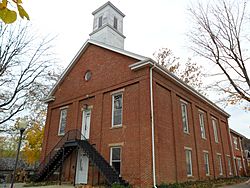
Brown County Courthouse in Nashville
|
|

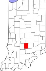
Location within the U.S. state of Indiana
|
|
 Indiana's location within the U.S. |
|
| Country | |
| State | |
| Founded | February 4, 1836 (created) August 1836 (organized) |
| Named for | Jacob Brown |
| Seat | Nashville |
| Largest city | Nashville |
| Area | |
| • Total | 316.22 sq mi (819.0 km2) |
| • Land | 311.58 sq mi (807.0 km2) |
| • Water | 4.65 sq mi (12.0 km2) 1.47%% |
| Population
(2020)
|
|
| • Total | 15,475 |
| • Estimate
(2023)
|
15,653 |
| • Density | 48.9374/sq mi (18.8949/km2) |
| Time zone | UTC−5 (Eastern) |
| • Summer (DST) | UTC−4 (EDT) |
| Congressional district | 9th |
| Website | http://browncounty-in.gov/Home.aspx |
|
|
Brown County is a special place in Indiana. In 2020, about 15,475 people lived here. The main town, and the only one with its own government, is Nashville. It's also the county seat, which means it's where the county government offices are.
History
Early Days

The land that is now Brown County was once home to Native Americans. The United States government gained this land through treaties in 1809 and 1818. No one was allowed to settle here until the government finished surveying the land in 1820.
The first known European person to arrive was Johann Schoonover, a German man. He lived by a creek (now named after him) around 1820 to trade with Native Americans. In the same year, William Elkins became the first pioneer to build a log cabin and clear land. The area where he settled later became known as Elkinsville.
Pioneers Arrive
The first pioneers came from states like Kentucky, Tennessee, Virginia, and the Carolinas. They traveled north on narrow Native American trails through thick forests. Many came to escape sickness from lowlands or because they preferred living in hilly areas.
By 1830, about 150 settlers had arrived. The population grew to 2,364 people by 1840.
Forming the County
By 1828, the land of future Brown County was split between Monroe, Jackson, and Bartholomew counties. In 1835, settlers asked the Indiana State Legislature for a new county. On February 4, 1836, a bill was passed to create Brown County.
The county was named after General Jacob Brown. He was a hero who won a battle against the British in the War of 1812. Brown County is about 16 miles (26 km) wide and 20 miles (32 km) long.
Building Nashville
In August 1836, the land was divided into five areas called townships. Nashville, which was then called Jacksonburg, was chosen as the county seat. A person named Banner C. Brummett was put in charge of planning Nashville. He sold lots of land at an auction to help pay for the new county government.
However, pioneers didn't have much money, so the lots sold slowly. For many years, the county struggled with money. In 1837, a log courthouse and jail were built. Nashville was just a small group of log cabins with about 75 people.
Life in the Wild
In 1836, the area was very wild. Bears, panthers, and wolves were common. There were so many wolves that the county paid $1 for every wolf skin brought to them! Settlers lived a tough pioneer life for many years. Their homes were tiny clearings in the huge forest that covered the hills and valleys.
Growth and Challenges
By 1872, when Nashville became an official town, there were many water-powered mills for grinding grain and cutting wood. Each small village had at least one general store, a blacksmith, a church, and a post office. Doctors lived in almost every village. By 1881, there were 20 doctors and 37 churches in the county.
Many immigrants came to Brown County, including people from England, Wales, and Germany. Some Presbyterian churches were made up entirely of people from Scotland who had moved to America from Ireland. They called themselves "Ulstermen" or "Irish Presbyterians."
Money was still hard to come by, so people often traded goods instead of using cash. The first schools were log cabins, but by 1872, there were many one-room schoolhouses. By 1900, there were 73 schools!
Forests and Poverty
People farmed, but they also relied on products from the forest to earn money. They cut down trees for lumber, railroad ties, and parts for barrels. Unfortunately, the trees were cut down too quickly. Since there wasn't enough farmland, people cleared trees from hillsides to plant crops. This caused a big problem: the soil washed away, making it impossible to grow crops.
By 1900, poverty was widespread, and many people left the county. Empty cabins were everywhere. In 1890, Brown County had 10,308 people. By 1930, only 5,168 remained. The population didn't reach the 1890 number again until 1980.
Connecting to the Outside World
In 1900, villages were still the main centers of life. Traveling was hard because roads were bumpy and rocky. Some people in remote areas never even visited Nashville in their whole lives! For many families, their only connection to the outside world was a salesman who visited weekly with his horse and wagon. Because of this, the pioneer way of life lasted longer in Brown County than in other places.
In 1905, a railroad line was built through the southwest part of Jackson Township. Helmsburg became the main station. Trains brought goods, mail, and people. Horse-drawn wagons then took mail and goods from the station to Nashville.
The first cars appeared in Nashville in 1913. At first, people didn't use them much because of the bad roads. Some people in Brown County even thought cars had a mind of their own and were harmful! As more cars arrived, county roads slowly got better. By 1934, State Road 135 was paved, and State Road 46 became one of the best gravel roads in the state before it was paved later.
Art and Nature
In 1907, artist T. C. Steele built a studio near Belmont. Another artist, Adolph Shulz, came to Nashville. This started the Brown County Art Colony. Many other artists moved to Nashville, and the Brown County Art Gallery opened in 1926. Today, Nashville is still a popular art center and tourist spot.
Brown County State Park opened in 1931. It offers a lodge, cabins, picnic areas, a swimming pool, and many trails. Other natural areas include Yellowwood State Forest, the Hoosier National Forest, Lake Monroe, and Lake Lemon.
Geography
Unlike many parts of Indiana, Brown County has rugged, hilly land. The valleys are filled with trees and plants. The highest point in the county is Weed Patch Hill, which is 1,058 feet (322 meters) above sea level. It's the third-highest point in Indiana.
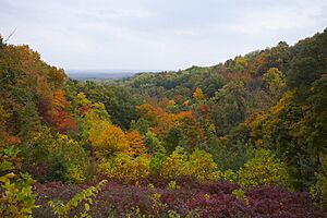
Brown County covers about 316.63 square miles (819.9 km²). Most of this (98.53%) is land, and a small part (1.47%) is water. Brown County has the most forested land of any county in Indiana, with almost 90% tree coverage. It also has very few large farms.
Adjacent counties
- Johnson County - northeast
- Bartholomew County - east
- Jackson County - south
- Monroe County - west
- Morgan County - northwest
Incorporated community
- Nashville (county seat)
Unincorporated communities
Former communities
- Oak Grove
- Dollsberry
- Beck
- Beveridge
- Buffalo
- Cleona
- Cooper
- Gent
- Kelp
- Lock
- Marble
- Marshall
- Ramelton
- Sherman
- Youno
Townships
- Hamblen
- Jackson
- Van Buren
- Washington
Census-designated place
Major highways
Protected areas
- Brown County State Park
- Cordry Sweetwater Conservancy District
- Hoosier National Forest (part)
- T. C. Steele State Historic Site
- Yellowwood State Forest
Lakes
- Lake Lemon
- Monroe Lake
Climate and weather
| Weather chart for Nashville, Indiana | |||||||||||||||||||||||||||||||||||||||||||||||
|---|---|---|---|---|---|---|---|---|---|---|---|---|---|---|---|---|---|---|---|---|---|---|---|---|---|---|---|---|---|---|---|---|---|---|---|---|---|---|---|---|---|---|---|---|---|---|---|
| J | F | M | A | M | J | J | A | S | O | N | D | ||||||||||||||||||||||||||||||||||||
|
2.7
36
19
|
2.7
42
23
|
3.7
52
32
|
4.3
64
41
|
5.1
74
52
|
4.1
82
61
|
4.3
86
65
|
4
84
62
|
3.6
78
55
|
3.1
67
44
|
4
54
35
|
3.4
41
24
|
||||||||||||||||||||||||||||||||||||
| temperatures in °F precipitation totals in inches source: The Weather Channel |
|||||||||||||||||||||||||||||||||||||||||||||||
|
Metric conversion
|
|||||||||||||||||||||||||||||||||||||||||||||||
In Nashville, the average temperature in January is about 19°F (-7°C). In July, it's around 86°F (30°C). The coldest temperature ever recorded was -21°F (-29°C) in January 1985. The hottest was 110°F (43°C) in July 1936.
The average rainfall changes throughout the year. January usually gets about 2.66 inches (6.8 cm) of rain, while May gets the most, with about 5.12 inches (13.0 cm).
Demographics
| Historical population | |||
|---|---|---|---|
| Census | Pop. | %± | |
| 1840 | 2,364 | — | |
| 1850 | 4,846 | 105.0% | |
| 1860 | 6,507 | 34.3% | |
| 1870 | 8,681 | 33.4% | |
| 1880 | 10,264 | 18.2% | |
| 1890 | 10,308 | 0.4% | |
| 1900 | 9,727 | −5.6% | |
| 1910 | 7,975 | −18.0% | |
| 1920 | 7,019 | −12.0% | |
| 1930 | 5,168 | −26.4% | |
| 1940 | 6,189 | 19.8% | |
| 1950 | 6,209 | 0.3% | |
| 1960 | 7,024 | 13.1% | |
| 1970 | 9,057 | 28.9% | |
| 1980 | 12,377 | 36.7% | |
| 1990 | 14,080 | 13.8% | |
| 2000 | 14,957 | 6.2% | |
| 2010 | 15,242 | 1.9% | |
| 2020 | 15,475 | 1.5% | |
| 2023 (est.) | 15,653 | 2.7% | |
| US Decennial Census 1790-1960 1900-1990 1990-2000 2010 |
|||
2010 Census
In 2010, Brown County had 15,242 people living in 6,199 households. About 4,444 of these were families. The county had about 48.9 people per square mile (18.9/km²). Most people (97.6%) were white. Small percentages were Asian, Native American, or Black. About 1.2% of the population was of Hispanic or Latino background.
Many people in Brown County have German (27.2%), Irish (13.1%), or English (11.6%) roots. Some people said their ancestry was "American." This often means their families have been in North America for a very long time, sometimes since the 1600s.
About 26.8% of households had children under 18. Most households (60.2%) were married couples. The average age of people in the county was 46.7 years old.
The average income for a household was $47,697. For families, it was $56,911. About 10.8% of the population lived below the poverty line. This included 17.2% of those under 18 and 6.5% of those 65 or older.
2020 Census
| Race | Num. | Perc. |
|---|---|---|
| White (NH) | 14,463 | 93.5% |
| Black or African American (NH) | 55 | 0.4% |
| Native American (NH) | 30 | 0.2% |
| Asian (NH) | 65 | 0.4% |
| Pacific Islander (NH) | 5 | 0.03% |
| Other/Mixed (NH) | 587 | 3.8% |
| Hispanic or Latino | 270 | 1.7% |
See also
 In Spanish: Condado de Brown (Indiana) para niños
 | Valerie Thomas |
 | Frederick McKinley Jones |
 | George Edward Alcorn Jr. |
 | Thomas Mensah |


