Bartholomew County, Indiana facts for kids
Quick facts for kids
Bartholomew County
|
|||
|---|---|---|---|

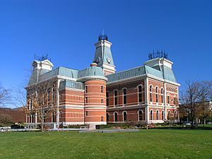
Bartholomew County courthouse in Columbus, Indiana
|
|||
|
|||

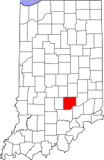
Location within the U.S. state of Indiana
|
|||
 Indiana's location within the U.S. |
|||
| Country | |||
| State | |||
| Founded | February 12, 1821 | ||
| Named for | Joseph Bartholomew | ||
| Seat | Columbus | ||
| Largest city | Columbus | ||
| Area | |||
| • Total | 409.52 sq mi (1,060.7 km2) | ||
| • Land | 406.91 sq mi (1,053.9 km2) | ||
| • Water | 2.62 sq mi (6.8 km2) 0.64%% | ||
| Population
(2020)
|
|||
| • Total | 82,208 | ||
| • Density | 189/sq mi (72.88/km2) | ||
| Time zone | UTC−5 (Eastern) | ||
| • Summer (DST) | UTC−4 (EDT) | ||
| Congressional district | 6th | ||
| Indiana county number 3 | |||
Bartholomew County is a special area, like a big district, located in the state of Indiana, USA. In 2020, about 82,208 people lived here. The main town, or "county seat," is Columbus. A long time ago, in 1900, the U.S. Census Bureau said that the very middle point of the U.S. population was in Bartholomew County!
Bartholomew County is part of the Columbus, Indiana Metropolitan Statistical Area. This means it's connected to a larger group of cities and towns, including the big Indianapolis area.
Contents
History of Bartholomew County
Bartholomew County was officially created on February 12, 1821. It was named after a brave soldier, Lt. Col. Joseph Bartholomew, who was hurt in a famous battle called the Battle of Tippecanoe. The place for the county's main town was picked on February 15, 1821. A group of leaders suggested calling it Tiptona, to honor John Tipton.
The Courthouse
The building where the county's government works, the Bartholomew County courthouse, was built between 1870 and 1874. It cost about $225,000 to build.
The courthouse was designed by an architect named Isaac Hodgson. He was born in Ireland in 1826 and moved to the United States in 1848. He designed six courthouses in Indiana, including the one in Henry County.
The courthouse is mostly made of brick. It has special sloped roofs called "mansard roofs," which were popular in a French style called Second Empire. The building has an unusual "L" shape, which lets it face two main streets in Columbus. You can see the names of the builders, the architect, and the date high up on the east side of the building.
Today, right next to the courthouse, there is a special memorial for veterans. It was designed by an American architect named Charles Rose.
Geography of Bartholomew County
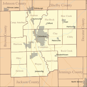
Bartholomew County covers a total area of about 409.52 square miles. Most of this area, about 406.91 square miles, is land. The rest, about 2.62 square miles, is water. A large military training area called Camp Atterbury is located in the northwest part of the county.
Neighboring Counties
- Johnson County (northwest)
- Shelby County (northeast)
- Decatur County (east)
- Jennings County (southeast)
- Jackson County (south)
- Brown County (west)
Main City
Towns in the County
Special Places (Census-designated)
Other Small Communities
- Azalia
- Bethany
- Burnsville
- Corn Brook
- Everroad Park
- Garden City
- Grammer
- Grandview Lake
- Jewell Village
- Mount Healthy
- Newbern
- North Ogilville
- Nortonburg
- Ogilville
- Old Saint Louis
- Petersville
- Rosstown
- Rugby
- Saint Louis Crossing
- Stony Lonesome
- Walesboro
- Waymansville
- Waynesville
Old Towns (No Longer Exist)
- Kansas
Townships (Smaller Divisions)
- Clay
- Clifty
- Columbus
- Flat Rock
- German
- Harrison
- Haw Creek
- Jackson
- Ohio
- Rock Creek
- Sand Creek
- Wayne
Transportation in the County
- ColumBUS (local bus service)
Main Roads
 Interstate 65
 U.S. Route 31
 State Road 7
 State Road 9
 State Road 11
 State Road 46
 State Road 58
Airport
- KBAK - Columbus Municipal Airport
Railroads
- Louisville and Indiana Railroad
Climate and Weather
| Weather chart for Columbus, Indiana | |||||||||||||||||||||||||||||||||||||||||||||||
|---|---|---|---|---|---|---|---|---|---|---|---|---|---|---|---|---|---|---|---|---|---|---|---|---|---|---|---|---|---|---|---|---|---|---|---|---|---|---|---|---|---|---|---|---|---|---|---|
| J | F | M | A | M | J | J | A | S | O | N | D | ||||||||||||||||||||||||||||||||||||
|
2.7
37
19
|
2.6
42
22
|
3.7
53
31
|
4.4
64
41
|
4.6
74
52
|
3.5
83
61
|
4
86
65
|
3.8
85
63
|
3.1
79
55
|
2.8
67
42
|
3.8
54
34
|
3.2
42
25
|
||||||||||||||||||||||||||||||||||||
| temperatures in °F precipitation totals in inches source: The Weather Channel |
|||||||||||||||||||||||||||||||||||||||||||||||
|
Metric conversion
|
|||||||||||||||||||||||||||||||||||||||||||||||
In recent years, the average temperatures in Columbus have changed quite a bit. In January, it's usually around 19°F (which is cold!). In July, it gets much warmer, around 86°F. The coldest temperature ever recorded was -27°F in January 1912. The hottest was 111°F in July 1934.
The amount of rain and snow (precipitation) also changes. On average, February gets about 2.63 inches of precipitation, while May gets the most, around 4.63 inches.
People of Bartholomew County (Demographics)
| Historical population | |||
|---|---|---|---|
| Census | Pop. | %± | |
| 1830 | 5,476 | — | |
| 1840 | 10,042 | 83.4% | |
| 1850 | 12,428 | 23.8% | |
| 1860 | 17,865 | 43.7% | |
| 1870 | 21,133 | 18.3% | |
| 1880 | 22,777 | 7.8% | |
| 1890 | 23,867 | 4.8% | |
| 1900 | 24,594 | 3.0% | |
| 1910 | 24,813 | 0.9% | |
| 1920 | 23,887 | −3.7% | |
| 1930 | 24,864 | 4.1% | |
| 1940 | 28,276 | 13.7% | |
| 1950 | 36,108 | 27.7% | |
| 1960 | 48,198 | 33.5% | |
| 1970 | 57,022 | 18.3% | |
| 1980 | 65,088 | 14.1% | |
| 1990 | 63,657 | −2.2% | |
| 2000 | 71,435 | 12.2% | |
| 2010 | 76,794 | 7.5% | |
| 2020 | 82,208 | 7.1% | |
| 2023 (est.) | 84,003 | 9.4% | |
| U.S. Decennial Census 1790-1960 1900-1990 1990-2000 2010-2013 |
|||
In 2020, there were 82,208 people living in Bartholomew County. There were also 31,452 households (groups of people living together). On average, there were about 188.7 people per square mile.
The people living in the county come from many different backgrounds. In 2020, about 80.0% of the people were white. About 6.6% were Asian, and 2.2% were Black or African American. About 0.4% were American Indian, and 0.1% were Pacific Islander. Another 4.7% were from other backgrounds, and 6.1% were from two or more backgrounds. People of Hispanic or Latino background made up 8.8% of the population.
Looking back at 2010, many people in the county had ancestors from Germany (28.5%), England (12.4%), Ireland (12.2%), and America (10.7%).
In 2010, about 34.6% of households had children under 18 living there. Most households (54.1%) were married couples living together. About 10.7% were households led by a woman without a husband present.
The average age of people in the county was 38.2 years old. In 2010, the average income for a household was $47,697 per year. For families, it was $64,024. About 10.4% of all people in the county lived below the poverty line. This included 15.8% of those under 18 and 5.3% of those 65 or older.
Education in Bartholomew County
The public schools in Bartholomew County are managed by two main groups: the Bartholomew Consolidated School Corporation and the Flat Rock-Hawcreek School Corporation.
A special public school, the International School of Columbus, opened in 2009–10. It was a middle school and high school that offered a special program called the International Baccalaureate Diploma Program.
For older students, Ivy Tech Community College Columbus is also located in Bartholomew County.
See also
 In Spanish: Condado de Bartholomew para niños
 | Kyle Baker |
 | Joseph Yoakum |
 | Laura Wheeler Waring |
 | Henry Ossawa Tanner |


