Corn Brook, Indiana facts for kids
Quick facts for kids
Corn Brook, Indiana
|
|
|---|---|

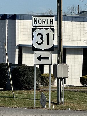
U.S. Route 31 sign in Corn Brook in 2023.
|
|

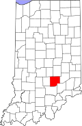
Bartholomew County's location in Indiana
|
|
| Country | United States |
| State | Indiana |
| County | Bartholomew |
| Township | Columbus |
| Elevation | 633 ft (193 m) |
| Time zone | UTC-5 (Eastern (EST)) |
| • Summer (DST) | UTC-4 (EDT) |
| ZIP code |
47203
|
| FIPS code | 18-15130 |
| GNIS feature ID | 432973 |
Corn Brook is a small place in Indiana, a state in the United States. It is known as an unincorporated community. This means it's a group of homes and businesses that don't have their own local government, like a city or town does. Instead, it's part of a larger area called a township.
Contents
What is Corn Brook?
Corn Brook is located in Bartholomew County. This county is in the central part of Indiana. The community is specifically within Columbus Township.
Where is Corn Brook located?
Corn Brook is found in the U.S. state of Indiana. Indiana is a state in the Midwest region of the United States. It is known for its farmlands and friendly communities.
Understanding Unincorporated Communities
An unincorporated community like Corn Brook does not have its own mayor or city council. Instead, services like roads and police are usually managed by the county government. This is different from a city, which has its own local rules and leaders.
Geography of Corn Brook
Corn Brook is situated at a specific point on the map. Its coordinates are 39 degrees North latitude and 85 degrees West longitude. This helps pinpoint its exact location in the world.
Elevation and Surroundings
The elevation of Corn Brook is about 633 feet (193 meters) above sea level. This means it's not very high up. The area around Corn Brook is typical of Indiana, with flat or gently rolling land.
How to Find Corn Brook
If you were looking for Corn Brook, you might see signs for U.S. Route 31. This is a major highway that passes near the community. Highways like this connect different towns and cities.
 | Selma Burke |
 | Pauline Powell Burns |
 | Frederick J. Brown |
 | Robert Blackburn |


